Mounted Print > Europe > United Kingdom > Northern Ireland > Maps
Mounted Print : Scotland, UK, satellite image


![]()
Mounted Prints from Science Photo Library
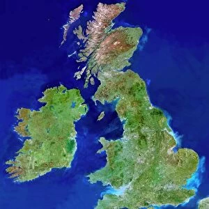
Scotland, UK, satellite image
Scotland, UK. North is at top. Natural colour satellite image showing Scotland in the United Kingdom, with the surrounding territories shaded out. The UK consists of the island of Great Britain and Northern Ireland - the north-eastern part of the island of Ireland (bottom left). Together these islands constitute the British Isles. Great Britain itself consists of Scotland (green), England (bottom right), and Wales (not seen). The Atlantic Ocean (blue, upper left), Irish Sea (blue, bottom centre), North Sea (blue, right) and Celtic Sea (not shown) surround the British Isles. Image compiled from data acquired by the LANDSAT 5 and 7 satellites, in 2000. Images highlighting all other regions of this country are available. For further information please
Science Photo Library features Science and Medical images including photos and illustrations
Media ID 9214449
© PLANETOBSERVER/SCIENCE PHOTO LIBRARY
2000 Atlantic Ocean Birds Eye View Border Borders Boundaries Boundary British Isles Cartography Coast Coastal Coastline Countries Country Earth Observation Environmental From Above From Space Frontier Frontiers Great Britain Highlands Ireland Irish Sea Island Islands Land Landsat 5 Landsat 7 Masked Mountain Mountains Nation Natural Colour Northern Ireland Relief Map Satellite Satellite Image Scotland Shore Shoreline State Topographic Topography Wales
10"x8" Mount with 8"x6" Print
Discover the breathtaking beauty of Scotland with our latest addition to the Media Storehouse Mounted Photos collection. This stunning, North-facing satellite image from Science Photo Library showcases the diverse landscapes of Scotland in the United Kingdom, with the surrounding territories tastefully shaded out. Bring a piece of the enchanting Scottish countryside into your home or office with this high-quality, mounted print. Perfect for adding a unique touch to any decor, or as a thoughtful gift for someone who cherishes the natural wonders of the UK.
Printed on 8"x6" paper and suitable for use in a 10"x8" frame (frame not included). Prints are mounted with card both front and back. Featuring a custom cut aperture to match chosen image. Professional 234gsm Fujifilm Crystal Archive DP II paper.
Photo prints supplied in custom cut card mount ready for framing
Estimated Image Size (if not cropped) is 14.4cm x 20.3cm (5.7" x 8")
Estimated Product Size is 20.3cm x 25.4cm (8" x 10")
These are individually made so all sizes are approximate
Artwork printed orientated as per the preview above, with portrait (vertical) orientation to match the source image.
FEATURES IN THESE COLLECTIONS
> Arts
> Artists
> O
> Oceanic Oceanic
> Arts
> Landscape paintings
> Coastal landscapes
> Nature-inspired artwork
> Arts
> Landscape paintings
> Coastal landscapes
> Ocean views
> Europe
> France
> Canton
> Landes
> Europe
> Republic of Ireland
> Maps
> Europe
> United Kingdom
> England
> Maps
> Europe
> United Kingdom
> Maps
> Europe
> United Kingdom
> Northern Ireland
> Maps
> Europe
> United Kingdom
> Northern Ireland
> Posters
> Europe
> United Kingdom
> Northern Ireland
> Related Images
EDITORS COMMENTS
This satellite image showcases the stunning landscape of Scotland, UK. The print captures the natural beauty of this European country, with its lush greenery and rugged mountains. From a bird's eye view, we can see Scotland (highlighted in vibrant green) as part of the United Kingdom, along with England (bottom right) and Wales (not visible). The surrounding territories have been shaded out to draw focus on Scotland's unique topography. The image also highlights the geographical features that define this region. The Atlantic Ocean dominates the upper left corner, while the Irish Sea is depicted in blue at the bottom center. To the right lies the North Sea, forming a natural boundary for these picturesque British Isles. Compiled from data acquired by LANDSAT 5 and 7 satellites in 2000, this high-resolution photograph offers an incredible glimpse into Scotland's diverse environment. Its coastline stretches along both sides of its mainland and numerous islands scattered throughout. With its majestic highlands and breathtaking mountain ranges, Scotland truly captivates nature enthusiasts worldwide. This satellite image provides a valuable tool for studying topography and understanding how landforms shape our planet.
MADE IN THE UK
Safe Shipping with 30 Day Money Back Guarantee
FREE PERSONALISATION*
We are proud to offer a range of customisation features including Personalised Captions, Color Filters and Picture Zoom Tools
SECURE PAYMENTS
We happily accept a wide range of payment options so you can pay for the things you need in the way that is most convenient for you
* Options may vary by product and licensing agreement. Zoomed Pictures can be adjusted in the Basket.