Fraud Blocker Skip to main content

Great Britain Collection

Great Britain, a land rich in history and natural beauty

Background imageGreat Britain Collection: Aurora Borealis over Sycamore Gap, Hadrians Wall, Northumberland, England

Aurora Borealis over Sycamore Gap, Hadrians Wall, Northumberland, England. February 2014

Background imageGreat Britain Collection: William Smith Geological Map

William Smith Geological Map

Background imageGreat Britain Collection: Scotland, Orkney Islands, Skara Brae Prehistoric Village

Scotland, Orkney Islands, Skara Brae Prehistoric Village. Skara Brae, a stone-built Neolithic settlement, located on the Bay of Skaill on the west coast of Mainland Orkney

Background imageGreat Britain Collection: Red squirrel (Sciurus vulgaris), two curled up asleep in drey inside nest box

Red squirrel (Sciurus vulgaris), two curled up asleep in drey inside nest box. Nest of lichen and Pine needles. Highlands, Scotland, UK. Medium repro only

Background imageGreat Britain Collection: Sycamore (Acer pseudoplatanus) in Sycamore Gap, Hadrians Wall

Sycamore (Acer pseudoplatanus) in Sycamore Gap, Hadrians Wall. The wall is constructed on The Whin Sill, a layer of hard intrusive, volcanic Dolerite

Background imageGreat Britain Collection: Circe Invidiosa, 1892. Artist: Waterhouse, John William (1849-1917)

Circe Invidiosa, 1892. Artist: Waterhouse, John William (1849-1917)
Circe Invidiosa, 1892. Found in the collection of the Art Gallery of South Australia

Background imageGreat Britain Collection: Marina, Findochty, Moray, Scotland, United Kingdom

Marina, Findochty, Moray, Scotland, United Kingdom

Background imageGreat Britain Collection: Gin Lane (Beer Street and Gin Lane 2), 1751. Artist: Hogarth, William (1697-1764)

Gin Lane (Beer Street and Gin Lane 2), 1751. Artist: Hogarth, William (1697-1764)
Gin Lane (Beer Street and Gin Lane 2), 1751. From a private collection

Background imageGreat Britain Collection: Antique map of Britain under the Anglo Saxons

Antique map of Britain under the Anglo Saxons

Background imageGreat Britain Collection: Reflections in Llyn Gwynant, Glaslyn valley looking north east, Snowdonia National Park

Reflections in Llyn Gwynant, Glaslyn valley looking north east, Snowdonia National Park, North Wales, UK, September

Background imageGreat Britain Collection: Bluebells (Hyacinthoides non-scripta) on Eype Down with Colmer's Hill in background, Bridport

Bluebells (Hyacinthoides non-scripta) on Eype Down with Colmer's Hill in background, Bridport, Dorset, England, UK. May 2014

Background imageGreat Britain Collection: Buzzard (Buteo buteo) in flight, portrait, Marlborough Downs, Wiltshire, UK. December

Buzzard (Buteo buteo) in flight, portrait, Marlborough Downs, Wiltshire, UK. December

Background imageGreat Britain Collection: Map of Anglo-Saxon Kingdoms and the Danelaw, 9th Century

Map of Anglo-Saxon Kingdoms and the Danelaw, 9th Century
Vintage engraving of a Map of Anglo-Saxon Kingdoms and the Danelaw, 9th Century

Background imageGreat Britain Collection: Flowering machair, South Uist, Outer Hebrides, Scotland, UK, July

Flowering machair, South Uist, Outer Hebrides, Scotland, UK, July

Background imageGreat Britain Collection: Leeds Castle, 12th

Leeds Castle, 12th c. Norman stronghold and royal residence, England

Background imageGreat Britain Collection: Map of England in 1066

Map of England in 1066
England at the time of the Norman conquest, 1066-1081. Color lithograph of a 19th-century illustration

Background imageGreat Britain Collection: Bayeaux Tapestry portraying the Norman Conquest

Bayeaux Tapestry portraying the Norman Conquest
Norman invasion of England in 1066 A.D. Color lithograph reproduction of part of the Bayeux tapestry

Background imageGreat Britain Collection: Common swifts (Apus apus) flying overhead, Wiltshire, UK, June. Digital composite image

Common swifts (Apus apus) flying overhead, Wiltshire, UK, June. Digital composite image

Background imageGreat Britain Collection: Oliver Cromwell at Edgehill, English Civil War

Oliver Cromwell at Edgehill, English Civil War
Cromwell in prayer before the Battle of Edgehill, English Civil War, 1642. Hand-colored woodcut reproduction of a 19th-century illustration

Background imageGreat Britain Collection: Map of England, 1800s

Map of England, 1800s
Map of England and Wales, 1870s. Color lithograph reproduction of a 19th-century illustration

Background imageGreat Britain Collection: Offas Dyke path leading to the summit of Moel Famau in the Clwydian Mountain Range

Offas Dyke path leading to the summit of Moel Famau in the Clwydian Mountain Range Clwyd, North Wales, UK, August

Background imageGreat Britain Collection: Cornwall map 1884

Cornwall map 1884
Encyclopedia Britannica 9th Edition New York Charles Scribners and Sons 1884 Vol VI

Background imageGreat Britain Collection: English suffragette, feminist newspaper, 1908

English suffragette, feminist newspaper, 1908. News seller, she is standing on the street not the pavement so as not to be arrested. The suffragettes published their own magazine / newspaper

Background imageGreat Britain Collection: Mary Anning (1799-1847)

Mary Anning (1799-1847)
Pioneer fossil collector of Lyme Regis, Dorset. Oil painting by an unknown artist, before 1842. Golden Cap is visible in the background. Held at the Natural History Museum, London

Background imageGreat Britain Collection: Scotland map, 1870s

Scotland map, 1870s
Map of Scotland, 1870s. Printed color lithograph

Background imageGreat Britain Collection: Map of Britain in 597 AD

Map of Britain in 597 AD
Map of territory controlled by Celts, Picts, Anglos, Saxons, and other tribes in Britain in 597 AD. Printed color lithograph of a 19th-century illustration

Background imageGreat Britain Collection: Trebarwith Strand at sunset and high water, Trebarwith, north Cornwall, UK. October 2017

Trebarwith Strand at sunset and high water, Trebarwith, north Cornwall, UK. October 2017

Background imageGreat Britain Collection: Starling murmuration, hundreds of thousands of starlings (Sturnus vulgaris)

Starling murmuration, hundreds of thousands of starlings (Sturnus vulgaris) gather in the skies near their night time roost. Gretna Green, Scotland, January

Background imageGreat Britain Collection: Shaugh Bridge in early spring, Shaugh Prior, near Plympton, Dartmoor National Park, Devon, UK

Shaugh Bridge in early spring, Shaugh Prior, near Plympton, Dartmoor National Park, Devon, UK. May 2018

Background imageGreat Britain Collection: The visit of the Queen of Sheba to King Solomon, 1890. Artist: Poynter, Edward John (1836-1919)

The visit of the Queen of Sheba to King Solomon, 1890. Artist: Poynter, Edward John (1836-1919)
The visit of the Queen of Sheba to King Solomon, 1890. Found in the collection of the Art Gallery of New South Wales

Background imageGreat Britain Collection: Mourne Mountains and Mt. Slieve Bearnagh, County Down, Northern Ireland, Ireland, Great Britain

Mourne Mountains and Mt. Slieve Bearnagh, County Down, Northern Ireland, Ireland, Great Britain, Europe

Background imageGreat Britain Collection: Miranda. The Tempest, 1916. Artist: Waterhouse, John William (1849-1917)

Miranda. The Tempest, 1916. Artist: Waterhouse, John William (1849-1917)
Miranda. The Tempest, 1916. Private Collection

Background imageGreat Britain Collection: Dickens Dream, 1875. Creator: Buss, Robert William (1804-1875)

Dickens Dream, 1875. Creator: Buss, Robert William (1804-1875)
Dickens Dream, 1875. Found in the collection of Charles Dickens Museum, London

Background imageGreat Britain Collection: Loch an Eilein with wooded edges in morning sun, Cairngorms National Park, Scotland

Loch an Eilein with wooded edges in morning sun, Cairngorms National Park, Scotland, UK, October 2015

Background imageGreat Britain Collection: Isle of Harris, part of the island Lewis and Harris in the Outer Hebrides of Scotland

Isle of Harris, part of the island Lewis and Harris in the Outer Hebrides of Scotland. Seilebost Beach on South Harris, in the background Sound of Transay and Luskentyre. Europe, Scotland, July

Background imageGreat Britain Collection: Ireland map, 1870s

Ireland map, 1870s
Map of Ireland, or Eire, 1870s. Printed color lithograph

Background imageGreat Britain Collection: The Scottish mountain Buachaille Etive Mor in Glen Etive near Glencoe in the Highlands of Scotland

The Scottish mountain Buachaille Etive Mor in Glen Etive near Glencoe in the Highlands of Scotland, UK, June 2017

Background imageGreat Britain Collection: Wigs for English lawyers, 1800s

Wigs for English lawyers, 1800s
Lawyer selecting the proper wig for appearance in court, London, 1800s. Hand-colored woodcut of a 19th-century illustration

Background imageGreat Britain Collection: William of Orange at the Battle of the Boyne, 1668

William of Orange at the Battle of the Boyne, 1668
William of Orange, later King William III of England, leading the Dutch army in Englands Glorious Revolution. Hand-colored engraving

Background imageGreat Britain Collection: Antique map, Liverpool and Birkenhead, England, 19th Century

Antique map, Liverpool and Birkenhead, England, 19th Century
Vintage engraving of a Antique map, Liverpool and Birkenhead, England, 19th Century

Background imageGreat Britain Collection: Holmes and Moriarty fighting over the Reichenbach Falls. Illustration for the short story The

Holmes and Moriarty fighting over the Reichenbach Falls. Illustration for the short story The Final Problem by Arthur Conan Do, 1896. From a private collection

Background imageGreat Britain Collection: View from the Top of Snowdon

View from the Top of Snowdon
View from the top of Snowdon looking down the Miners Track North Wales England. The Miners Track was built to serve the Britannia Copper Mine on Snowdon but it is not the route originally used to

Background imageGreat Britain Collection: Great Britain and Ireland map 1867

Great Britain and Ireland map 1867
Mitchell's Modern Atlas - Published by E.H. Butler and Co - Philadelphia 1867

Background imageGreat Britain Collection: Geological map of Britain and Ireland

Geological map of Britain and Ireland
Fig 9 from Britain Before Man (1978), a Geological Museum publication

Background imageGreat Britain Collection: England, Northumberland, Newbiggin by the sea

England, Northumberland, Newbiggin by the sea. Coal dust revealed by a retreating wave on the Newbiggin by the sea beach

Background imageGreat Britain Collection: GGBR2A-00076

GGBR2A-00076
Map of Scotland in the 1520s, showing territories of the Highland Clans. Printed color lithograph of a 19th century illustration

Background imageGreat Britain Collection: Childrens Political British Isles Map

Childrens Political British Isles Map
The British Isles Political map designed for school children was created using Universal Transverse Mercator projection. This political student map clearly marks the counties

Background imageGreat Britain Collection: Antique map, Scotland, Jura, Mull, Argyll, Islay 19th Century

Antique map, Scotland, Jura, Mull, Argyll, Islay 19th Century
Vintage engraving of a Antique map, Scotland, Jura, Mull, Argyll, Islay 19th Century


All Professionally Made to Order for Quick Shipping

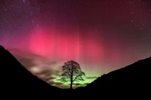
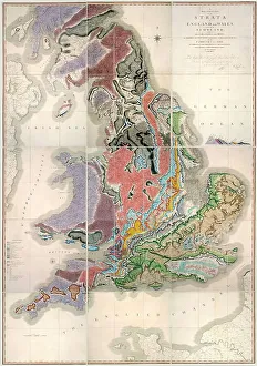
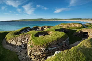
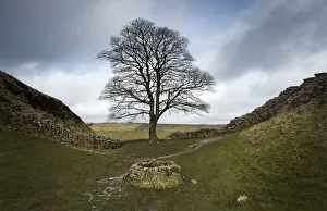
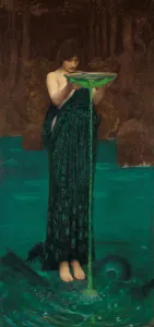
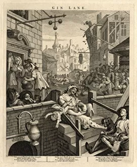
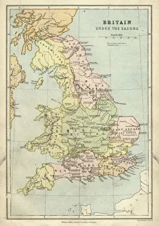
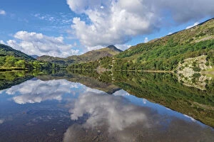
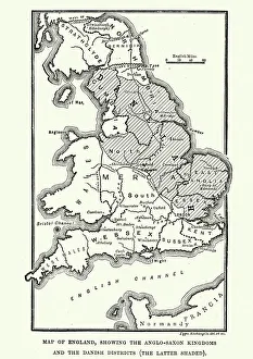
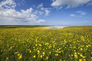
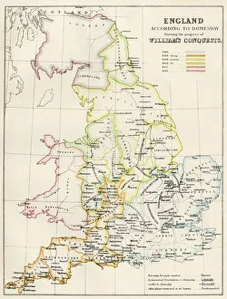
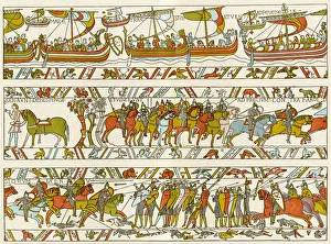
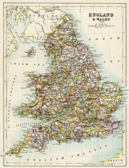
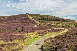
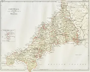
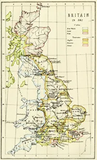
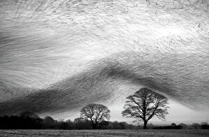
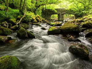
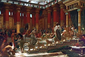
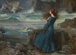
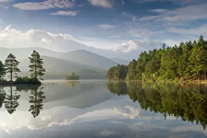
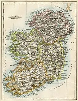
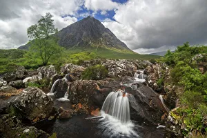
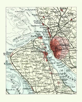
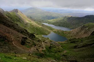
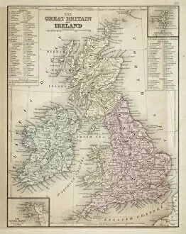
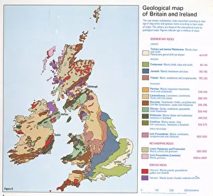
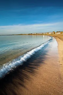
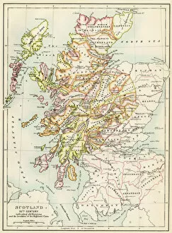
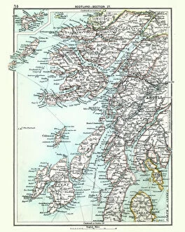
Great Britain, a land rich in history and natural beauty. From the intricate details of the William Smith Geological Map to the peaceful sight of two red squirrels curled up asleep in their lichen-covered nest box, this country is a treasure trove of wonders. Delve into the past with an antique map showcasing Britain under the rule of Anglo-Saxons or explore the kingdoms and Danelaw during the 9th century through another historical map. Look up to witness common swifts gracefully soaring overhead, creating a mesmerizing digital composite image against Wiltshire's sky in June. Venture towards Northern Ireland and be captivated by the majestic Mourne Mountains and Mt. Slieve Bearnagh standing tall amidst County Down's breathtaking landscapes. Marvel at Bayeux Tapestry as it portrays scenes from Norman Conquest, offering glimpses into Great Britain's dramatic history. Travel back even further with a Cornwall map from 1884 or immerse yourself in England's landscape during 1066 through yet another historical depiction. Experience tranquility at Loch an Eilein as its wooded edges bask in morning sun within Cairngorms National Park, Scotland. And finally, let your imagination wander to ancient tales depicted by Edward John Poynter's artwork "The visit of Queen Sheba to King Solomon" - a reminder that Great Britain has been inspiring artists for centuries. Don't forget to explore Isle of Harris within Scotland's Outer Hebrides; it offers stunning vistas that will leave you breathless. In essence, Great Britain is more than just a name on a map; it is an amalgamation of geological marvels, diverse wildlife, captivating history, and awe-inspiring landscapes that continue to enchant visitors from around the world.