Fine Art Print > Europe > United Kingdom > England > London > Art > Theatre
Fine Art Print : Map of South Africa, c1914, (c1920). Creator: John Bartholomew & Son
. Creator: John Bartholomew & Son")


![]()
Fine Art Prints from Heritage Images
Map of South Africa, c1914, (c1920). Creator: John Bartholomew & Son
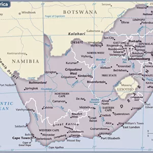
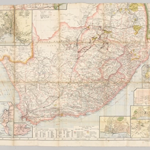
Map of South Africa, c1914, (c1920). Map of the southern tip of Africa at the start of the First World War, showing German South-West Africa (later Namibia), and various provinces of South Africa including the Bechuanaland Protectorate, Transvaal, Natal, Orange Free State, and Zululand. From " The Great World War - A History" Volume I, edited by Frank A Mumby. [The Gresham Publishing Company Ltd, London, c1920]
Heritage Images features heritage image collections
Media ID 19175045
© The Print Collector/Heritage Images
Bartholomew Bartholomew And Co Bartholomew Co Bartholomew John Son Frank Arthur Frank Arthur Mumby Gresham Publishing Co Ltd Gresham Publishing Company Jg Bartholomew John And Son John Bartholomew And Co John Bartholomew And Son John Bartholomew And Son Ltd John Bartholomew Co John Bartholomew Son John Bartholomew Son Ltd John Son Keystone Archives Mumby Mumby Frank Arthur Namibia Namibia Africa Natal Natal South Africa Orange Free State South Africa Territorial Territory The Great World War A History Theatre Of War Transvaal Transvaal South Africa Zululand Bechuanaland British Empire South West Africa Swaziland
A2 (42x59cm) Fine Art Print
Step back in time with our exquisite Fine Art Print of the Map of South Africa, circa 1914-1920, by renowned cartographers John Bartholomew & Son. This captivating vintage map offers a unique glimpse into history, depicting the southern tip of Africa at the onset of the First World War. The map showcases the intricate detail of the African continent during this era, including German South-West Africa, later known as Namibia. Add an air of nostalgia and historical charm to your home or office with this beautiful, museum-quality print.
Our Fine Art Prints are printed on 100% acid free, PH neutral paper with archival properties. This printing method is used by museums and art collections to exhibit photographs and art reproductions. Hahnemühle certified studio for digital fine art printing. Printed on 308gsm Photo Rag Paper.
Our fine art prints are high-quality prints made using a paper called Photo Rag. This 100% cotton rag fibre paper is known for its exceptional image sharpness, rich colors, and high level of detail, making it a popular choice for professional photographers and artists. Photo rag paper is our clear recommendation for a fine art paper print. If you can afford to spend more on a higher quality paper, then Photo Rag is our clear recommendation for a fine art paper print.
Estimated Image Size (if not cropped) is 55.9cm x 42cm (22" x 16.5")
Estimated Product Size is 59.4cm x 42cm (23.4" x 16.5")
These are individually made so all sizes are approximate
Artwork printed orientated as per the preview above, with landscape (horizontal) orientation to match the source image.
FEATURES IN THESE COLLECTIONS
> Africa
> Namibia
> Related Images
> Africa
> South Africa
> Maps
> Africa
> South Africa
> Related Images
> Africa
> Swaziland (Eswatini)
> Related Images
> Europe
> United Kingdom
> England
> London
> Art
> Theatre
> Historic
> World War I and II
> World War I
> Historic
> World War I and II
> Maps and Charts
> British Empire Maps
EDITORS COMMENTS
This print showcases a Map of South Africa, dating back to around 1914 but printed in the early 1920s. Created by John Bartholomew & Son, this historical artifact provides a glimpse into the southern tip of Africa at the onset of the First World War. The map depicts various provinces of South Africa, including Transvaal, Natal, Orange Free State, and Zululand. It also highlights German South-West Africa (later known as Namibia) and the Bechuanaland Protectorate. Taken from "The Great World War - A History". Volume I edited by Frank A Mumby and published by The Gresham Publishing Company Ltd in London during approximately 1920, this remarkable piece offers valuable insights into the territorial landscape during that tumultuous period. With its vibrant colors and intricate details, this map serves as a visual representation of not only geographical boundaries but also political affiliations within the British Empire. As an educational resource or decorative element for history enthusiasts or collectors alike, it holds immense value. Preserved by Heritage Images and credited to John Bartholomew & Son Ltd. , this print is a testament to their expertise in cartography. Its presence evokes curiosity about past events while reminding us of how our world has evolved over time.
MADE IN THE UK
Safe Shipping with 30 Day Money Back Guarantee
FREE PERSONALISATION*
We are proud to offer a range of customisation features including Personalised Captions, Color Filters and Picture Zoom Tools
SECURE PAYMENTS
We happily accept a wide range of payment options so you can pay for the things you need in the way that is most convenient for you
* Options may vary by product and licensing agreement. Zoomed Pictures can be adjusted in the Basket.