Fraud Blocker Skip to main content

John Bartholomew And Son Ltd Collection

"Exploring the World through John Bartholomew & Son Ltd

Background imageJohn Bartholomew And Son Ltd Collection: Map of the North Sea and the Baltic, c1914, (c1920). Creator: John Bartholomew & Son

Map of the North Sea and the Baltic, c1914, (c1920). Creator: John Bartholomew & Son
Map of the North Sea and the Baltic, c1914, (c1920). Northern Europe at the start of the First World War, including parts of Norway, Sweden, Finland, Russia, Germany, Denmark

Background imageJohn Bartholomew And Son Ltd Collection: The Baltic Sea and Its Approaches, First World War, c1915, (c1920)

The Baltic Sea and Its Approaches, First World War, c1915, (c1920). Map of part of northern Europe, showing sections of the coasts of Norway, Sweden, Russia, Germany and Denmark

Background imageJohn Bartholomew And Son Ltd Collection: Map of German South West Africa, First World War, (c1920). Creator: John Bartholomew & Son

Map of German South West Africa, First World War, (c1920). Creator: John Bartholomew & Son
Map of German South West Africa, First World War, (c1920). The German annexation of South West Africa took place in the 1880s

Background imageJohn Bartholomew And Son Ltd Collection: Austria-Hungary and Neighbouring Lands - Map, 1920. Creator: John Bartholomew & Son

Austria-Hungary and Neighbouring Lands - Map, 1920. Creator: John Bartholomew & Son
Austria-Hungary and Neighbouring Lands, c1914, (c1920). Map of the Austro-Hungarian Empire and surrounding countries at start of the First World War

Background imageJohn Bartholomew And Son Ltd Collection: Political Map of Africa, 1914, (1920). Creator: John Bartholomew & Son

Political Map of Africa, 1914, (1920). Creator: John Bartholomew & Son
Political Map of Africa, 1914, (1920). Colonial possessions in Africa at the start of the First World War. British colonies are pink, French - green, German - orange, Portuguese - purple

Background imageJohn Bartholomew And Son Ltd Collection: India and the Campaigns of the Middle East, First World War, 1914-1918, (c1920)

India and the Campaigns of the Middle East, First World War, 1914-1918, (c1920). Map showing British India coloured pink as part of the British Empire, Afghanistan, Persia, Asia Minor, Arabia

Background imageJohn Bartholomew And Son Ltd Collection: Map of the Austro-Italian frontier, First World War, (c1920). Creator: John Bartholomew & Son

Map of the Austro-Italian frontier, First World War, (c1920). Creator: John Bartholomew & Son
Map of the Austro-Italian frontier, First World War, (c1920). Mountainous area between Salzburg, Trieste and Cremona, showing the Tyrol

Background imageJohn Bartholomew And Son Ltd Collection: Asia Minor, the Caucasus Region and Mesopotamia, First World War, c1915, (c1920)

Asia Minor, the Caucasus Region and Mesopotamia, First World War, c1915, (c1920). Map of part of the Middle East, showing eastern Turkey, Cyprus, Syria, Lebanon, Palestine

Background imageJohn Bartholomew And Son Ltd Collection: Map of East Africa, First World War, (c1920). Creator: John Bartholomew & Son

Map of East Africa, First World War, (c1920). Creator: John Bartholomew & Son
Map of East Africa, First World War, (c1920). Map showing colonial possessions including the Belgian Congo, British East Africa, German East Africa, Northern Rhodesia and Portuguese East Africa

Background imageJohn Bartholomew And Son Ltd Collection: Black Sea: Bosphorus and Dardanelles, c1914, (c1920). Creator: John Bartholomew & Son

Black Sea: Bosphorus and Dardanelles, c1914, (c1920). Creator: John Bartholomew & Son
Black Sea: Bosphorus and Dardanelles, c1914, (c1920). Map of the Black Sea and parts of surrounding countries at the start of the First World War, showing Russia and the Crimea, Romania

Background imageJohn Bartholomew And Son Ltd Collection: Map of South Africa, c1914, (c1920). Creator: John Bartholomew & Son

Map of South Africa, c1914, (c1920). Creator: John Bartholomew & Son
Map of South Africa, c1914, (c1920). Map of the southern tip of Africa at the start of the First World War, showing German South-West Africa (later Namibia)

Background imageJohn Bartholomew And Son Ltd Collection: The Balkan States After the Wars of 1912-13, (c1920). Creator: John Bartholomew & Son

The Balkan States After the Wars of 1912-13, (c1920). Creator: John Bartholomew & Son
The Balkan States After the Wars of 1912-13, (c1920). Showing Acquisitions of Territory in Darker Tints. Map of the Balkans: Bosnia, Montenegro, Servia (Serbia), Albania, Roumania (Romania)

Background imageJohn Bartholomew And Son Ltd Collection: Poland and the Partitions of 1772, 1793 & 1795, (c1920). Creator: John Bartholomew & Son

Poland and the Partitions of 1772, 1793 & 1795, (c1920). Creator: John Bartholomew & Son
Poland and the Partitions of 1772, 1793 & 1795, (c1920). Map showing how territory in Europe was divided between the empires of Russia, Prussia and Austria in the 18th century

Background imageJohn Bartholomew And Son Ltd Collection: Map of Central Europe, c1914. Creator: John Bartholomew & Son

Map of Central Europe, c1914. Creator: John Bartholomew & Son
Map of Central Europe, c1914. Europe as it looked at the beginning of the First World War. From " The Great World War - A History" Volume I, edited by Frank A Mumby

Background imageJohn Bartholomew And Son Ltd Collection: Map of Belgium and Northern France, c1914, (c1920). Creator: John Bartholomew & Son

Map of Belgium and Northern France, c1914, (c1920). Creator: John Bartholomew & Son
Map of Belgium and Northern France, c1914, (c1920). How the area looked at the start of the First World War. From " The Great World War - A History" Volume I, edited by Frank A Mumby

Background imageJohn Bartholomew And Son Ltd Collection: Poland, 1815-1914, (c1920). Creator: John Bartholomew & Son

Poland, 1815-1914, (c1920). Creator: John Bartholomew & Son
Poland, 1815-1914, (c1920). Map showing Polish territory from the end of the 18th century until the First World War: Poland as constituted in 1815, and Poland before partition of 1772

Background imageJohn Bartholomew And Son Ltd Collection: East-European Theatre of War, 1914-1918, (c1920). Creator: John Bartholomew & Son

East-European Theatre of War, 1914-1918, (c1920). Creator: John Bartholomew & Son
East-European Theatre of War, 1914-1918, (c1920). Map of Eastern Europe during the First World War, showing parts of Germany, Russia and Austria-Hungary

Background imageJohn Bartholomew And Son Ltd Collection: Northern France Illustrating the Western Campaign, 1914, (c1920)

Northern France Illustrating the Western Campaign, 1914, (c1920). Map of northern France, Belgium and Luxembourg, at the start of the First World War


All Professionally Made to Order for Quick Shipping

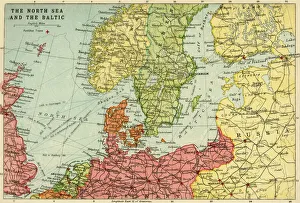
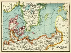
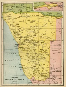
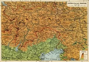
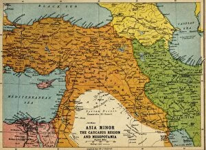
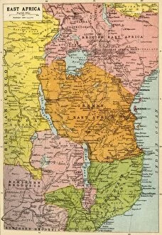
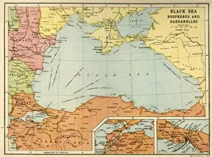
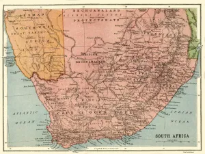
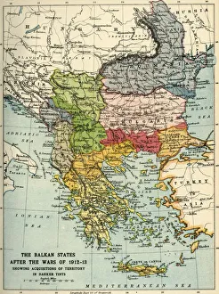
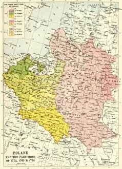
"Exploring the World through John Bartholomew & Son Ltd: A Cartographic Journey" Step into a world of intricate maps and historical significance with John Bartholomew & Son Ltd. This renowned cartography company, established in the early 20th century, has left an indelible mark on our understanding of global geography. Delve into their collection and discover treasures like "Map of the North Sea and the Baltic, c1914, " which provides a glimpse into maritime routes during that era. Feel the weight of history as you explore "The Baltic Sea and Its Approaches, First World War, " shedding light on naval strategies employed during this tumultuous period. Travel to distant lands with "Map of German South West Africa, First World War, " transporting yourself to a time when borders were shifting amidst conflict. Uncover the intricacies of Europe's political landscape with "Austria-Hungary and Neighbouring Lands - Map, 1920, " offering insight into post-war territorial changes. Venture further south with "Political Map of Africa, 1914, " capturing a continent on the brink of transformation. Witness how war shaped boundaries in "Map of the Austro-Italian frontier, First World War. " Immerse yourself in regions like Asia Minor and Mesopotamia through their map from c1915. Experience African landscapes come alive with "Map of East Africa, First World War. " Marvel at strategic waterways such as Bosphorus and Dardanelles in Black Sea's depiction from c1914. Traverse vast terrains through their detailed portrayal in "Map of South Africa. " Unravel complex histories within Balkan States after wars concluded by exploring " (c1920). " Lastly, journey back centuries ago to Poland's partitions via " (c1920)" map—truly showcasing John Bartholomew & Son Ltd. 's dedication to preserving historical narratives. With each meticulously crafted map, John Bartholomew & Son Ltd.