Premium Framed Print > Europe > Denmark > Maps
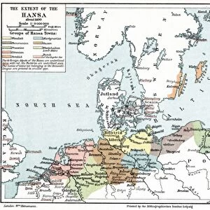
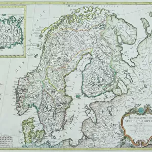
Premium Framed Print : Map of the North Sea and the Baltic, c1914, (c1920). Creator: John Bartholomew & Son
. Creator: John Bartholomew & Son")
. Creator: John Bartholomew & Son")


![]()
Framed Photos from Heritage Images
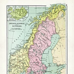
Map of the North Sea and the Baltic, c1914, (c1920). Creator: John Bartholomew & Son
Map of the North Sea and the Baltic, c1914, (c1920). Northern Europe at the start of the First World War, including parts of Norway, Sweden, Finland, Russia, Germany, Denmark, Great Britain and Holland. From " The Great World War - A History" Volume II, edited by Frank A Mumby. [The Gresham Publishing Company Ltd, London, c1920]
Heritage Images features heritage image collections
Media ID 19175121
© The Print Collector/Heritage Images
Baltic Sea Bartholomew Bartholomew And Co Bartholomew Co Bartholomew John Son Coastline Finland Frank Arthur Frank Arthur Mumby Great Britain Gresham Publishing Co Ltd Gresham Publishing Company Jg Bartholomew John And Son John Bartholomew And Co John Bartholomew And Son John Bartholomew And Son Ltd John Bartholomew Co John Bartholomew Son John Bartholomew Son Ltd John Son Keystone Archives Mumby Mumby Frank Arthur Nation North Sea Norway The Great World War A History Theatre Of War
23"x19" (58x48cm) Premium Frame
FSC real wood frame with double mounted 16x12 print. Double mounted with white conservation mountboard. Frame moulding comprises stained composite natural wood veneers (Finger Jointed Pine) 39mm wide by 21mm thick. Archival quality Fujifilm CA photo paper mounted onto 1mm card. Overall outside dimensions are 23x19 inches (584x482mm). Rear features Framing tape to cover staples, 50mm Hanger plate, cork bumpers. Glazed with durable thick 2mm Acrylic to provide a virtually unbreakable glass-like finish. Acrylic Glass is far safer, more flexible and much lighter than typical mineral glass. Moreover, its higher translucency makes it a perfect carrier for photo prints. Acrylic allows a little more light to penetrate the surface than conventional glass and absorbs UV rays so that the image and the picture quality doesn't suffer under direct sunlight even after many years. Easily cleaned with a damp cloth. Please note that, to prevent the paper falling through the mount window and to prevent cropping of the original artwork, the visible print may be slightly smaller to allow the paper to be securely attached to the mount without any white edging showing and to match the aspect ratio of the original artwork.
FSC Real Wood Frame and Double Mounted with White Conservation Mountboard - Professionally Made and Ready to Hang
Estimated Image Size (if not cropped) is 39.6cm x 26.8cm (15.6" x 10.6")
Estimated Product Size is 58.4cm x 48.2cm (23" x 19")
These are individually made so all sizes are approximate
Artwork printed orientated as per the preview above, with landscape (horizontal) orientation to match the source image.
FEATURES IN THESE COLLECTIONS
> Europe
> Denmark
> Related Images
> Europe
> Finland
> Related Images
> Europe
> Norway
> Related Images
EDITORS COMMENTS
This print showcases a meticulously detailed "Map of the North Sea and the Baltic" from around 1914, expertly created by John Bartholomew & Son. The map provides a fascinating glimpse into Northern Europe at the onset of the First World War, encompassing regions such as Norway, Sweden, Finland, Russia, Germany, Denmark, Great Britain, and Holland. The vibrant colors used in this print bring life to the coastal areas depicted along the North Sea and Baltic coastlines. It serves as a powerful reminder of how geography played a crucial role during this tumultuous period in history. As we explore this historical masterpiece further within its context in Frank A Mumby's book "The Great World War - A History". Volume II published by The Gresham Publishing Company Ltd in London around 1920; it becomes evident that this map was an essential tool for understanding the theater of war during World War I. John Bartholomew & Son's expertise shines through their intricate cartography skills showcased here. Their attention to detail allows us to visualize nations and geographical features with precision. This remarkable piece not only serves as an educational resource but also stands as a testament to their dedication and craftsmanship. With every glance at this extraordinary print from Heritage Images' collection curated by John Bartholomew & Son Ltd. , we are transported back in time to witness firsthand how borders shifted and alliances were formed amidst one of history's most significant conflicts.
MADE IN THE UK
Safe Shipping with 30 Day Money Back Guarantee
FREE PERSONALISATION*
We are proud to offer a range of customisation features including Personalised Captions, Color Filters and Picture Zoom Tools
SECURE PAYMENTS
We happily accept a wide range of payment options so you can pay for the things you need in the way that is most convenient for you
* Options may vary by product and licensing agreement. Zoomed Pictures can be adjusted in the Basket.