Home > Europe > Norway > Maps
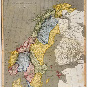
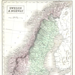
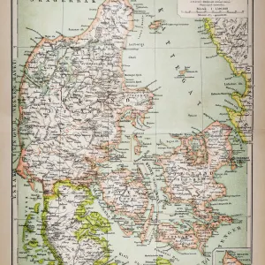
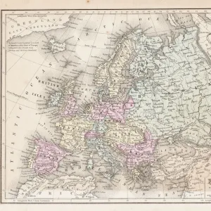
1864, Johnson Map of Scandinavia, Norway, Sweden, Denmark, Prussia, topography, cartography

![]()
Wall Art and Photo Gifts from Liszt Collection
1864, Johnson Map of Scandinavia, Norway, Sweden, Denmark, Prussia, topography, cartography
1864, Johnson Map of Scandinavia, Norway, Sweden, Denmark, Prussia
Liszt Collection of nineteenth-century engravings and images to browse and enjoy
Media ID 14006025
© Artokoloro Quint Lox Limited
1864 Denmark Norway Prussia Sweden Antique Map Atlas Chart Geographic Latitude Longitude Mappa Mundi Old Antique Plan Old Antique View Old Map Ols Antique Map Rare Old Maps Topo
FEATURES IN THESE COLLECTIONS
> Maps and Charts
> Early Maps
> Maps and Charts
> World
EDITORS COMMENTS
This print showcases the remarkable "1864, Johnson Map of Scandinavia, Norway, Sweden, Denmark, Prussia". A true masterpiece in cartography and topography, this vintage map takes us back to a time when exploration and discovery were at their peak. The intricate details depicted on this ancient piece of art provide a fascinating glimpse into the geographical landscape of these Scandinavian countries. The carefully drawn lines and grids represent latitude and longitude coordinates that guided travelers through this enchanting region. Each stroke tells a story of historic journeys taken by brave explorers who ventured into unknown territories. This rare old map not only serves as a navigational tool but also as an artistic representation of our world's history. Printed on aged paper with decorative elements adding to its charm, this antique map is truly a treasure for any history enthusiast or geography lover. Its delicate illustrations transport us to another era when maps were meticulously crafted by skilled artisans. As we admire this Johnson Map from 1864, we are reminded of the vastness and beauty that lies within our planet's diverse regions. It serves as a reminder that even in today's modern age where technology guides our every step, there is still value in appreciating the historical significance and artistry found in these timeless relics from the past.
MADE IN THE UK
Safe Shipping with 30 Day Money Back Guarantee
FREE PERSONALISATION*
We are proud to offer a range of customisation features including Personalised Captions, Color Filters and Picture Zoom Tools
SECURE PAYMENTS
We happily accept a wide range of payment options so you can pay for the things you need in the way that is most convenient for you
* Options may vary by product and licensing agreement. Zoomed Pictures can be adjusted in the Basket.