Fraud Blocker Skip to main content

Rare Old Maps Collection

"Unveiling the Treasures

Background imageRare Old Maps Collection: 1768, James Craig Map of New Town, Edinburgh, Scotland, First Plan of New Town, topography

1768, James Craig Map of New Town, Edinburgh, Scotland, First Plan of New Town, topography
1768, James Craig Map of New Town, Edinburgh, Scotland, First Plan of New Town

Background imageRare Old Maps Collection: 1794, Delisle Map of Southern Ancient Greece, Greeks Isles, and Crete, topography

1794, Delisle Map of Southern Ancient Greece, Greeks Isles, and Crete, topography
1794, Delisle Map of Southern Ancient Greece, Greeks Isles, and Crete

Background imageRare Old Maps Collection: 1886, Telescopic View and Map of the Moon, topography, cartography, geography, land

1886, Telescopic View and Map of the Moon, topography, cartography, geography, land
1886, Telescopic View and Map of the Moon

Background imageRare Old Maps Collection: 1865, Spruner Map of Greece, Macedonia and Thrace before the Peloponnesian War. topography

1865, Spruner Map of Greece, Macedonia and Thrace before the Peloponnesian War. topography
1865, Spruner Map of Greece, Macedonia and Thrace before the Peloponnesian War

Background imageRare Old Maps Collection: 1658, Visscher Map of North America and South America, topography, cartography, geography

1658, Visscher Map of North America and South America, topography, cartography, geography
1658, Visscher Map of North America and South America

Background imageRare Old Maps Collection: 1855, Colton Map of Scandinavia, Norway, Sweden, Finland, topography, cartography

1855, Colton Map of Scandinavia, Norway, Sweden, Finland, topography, cartography
1855, Colton Map of Scandinavia, Norway, Sweden, Finland

Background imageRare Old Maps Collection: 1855, Colton Map of Persia, Afghanistan, and Arabia, topography, cartography, geography

1855, Colton Map of Persia, Afghanistan, and Arabia, topography, cartography, geography
1855, Colton Map of Persia, Afghanistan, and Arabia

Background imageRare Old Maps Collection: 1848, Crutchley Pocket Map or Plan of London, England, topography, cartography, geography

1848, Crutchley Pocket Map or Plan of London, England, topography, cartography, geography
1848, Crutchley Pocket Map or Plan of London, England

Background imageRare Old Maps Collection: 1818, Pinkerton Map of the British Isles, England, Scotland, Ireland, John Pinkerton

1818, Pinkerton Map of the British Isles, England, Scotland, Ireland, John Pinkerton, 1758 - 1826, Scottish antiquarian, cartographer, UK

Background imageRare Old Maps Collection: 1864, Johnson Map of Washington, Oregon, and Idaho, topography, cartography, geography

1864, Johnson Map of Washington, Oregon, and Idaho, topography, cartography, geography
1864, Johnson Map of Washington, Oregon, and Idaho

Background imageRare Old Maps Collection: 1706, De La Feuille Map of Europe, topography, cartography, geography, land, illustration

1706, De La Feuille Map of Europe, topography, cartography, geography, land, illustration
1706, De La Feuille Map of Europe

Background imageRare Old Maps Collection: 1750, Homann Heirs Map of Poland, topography, cartography, geography, land, illustration

1750, Homann Heirs Map of Poland, topography, cartography, geography, land, illustration
1750, Homann Heirs Map of Poland

Background imageRare Old Maps Collection: 1890, Bacon Travelers Pocket Map of London, England, topography, cartography

1890, Bacon Travelers Pocket Map of London, England, topography, cartography
1890, Bacon Travelers Pocket Map of London, England

Background imageRare Old Maps Collection: 1865, Spruner Map of Israel, Canaan, or Palestine in Ancient Times, topography, cartography

1865, Spruner Map of Israel, Canaan, or Palestine in Ancient Times, topography, cartography
1865, Spruner Map of Israel, Canaan, or Palestine in Ancient Times

Background imageRare Old Maps Collection: 1570, Ortelius Map of Asia, first edition, Abraham Ortelius, also Orthellius, 1527 - 1598

1570, Ortelius Map of Asia, first edition, Abraham Ortelius, also Orthellius, 1527 - 1598, Flemish, Netherlandish cartographer and geographer

Background imageRare Old Maps Collection: 1818, Pinkerton Map of Chile, John Pinkerton, 1758 - 1826, Scottish antiquarian, cartographer

1818, Pinkerton Map of Chile, John Pinkerton, 1758 - 1826, Scottish antiquarian, cartographer, UK

Background imageRare Old Maps Collection: 1784, Bocage Map of the City of Athens in Ancient Greece, topography, cartography

1784, Bocage Map of the City of Athens in Ancient Greece, topography, cartography
1784, Bocage Map of the City of Athens in Ancient Greece

Background imageRare Old Maps Collection: 1865, Spruner Map of the British Isles, England, Scotland, Ireland, topography, cartography

1865, Spruner Map of the British Isles, England, Scotland, Ireland, topography, cartography
1865, Spruner Map of the British Isles, England, Scotland, Ireland

Background imageRare Old Maps Collection: 1839, Bradford Map of New York City, New York, topography, cartography, geography

1839, Bradford Map of New York City, New York, topography, cartography, geography
1839, Bradford Map of New York City, New York

Background imageRare Old Maps Collection: 1770, Bonne Map of China, Korea, Japan and Formosa, Rigobert Bonne 1727 - 1794, one

1770, Bonne Map of China, Korea, Japan and Formosa, Rigobert Bonne 1727 - 1794, one of the most important cartographers of the late 18th century

Background imageRare Old Maps Collection: 1683, Mortier Map of North America, the West Indies, and the Atlantic Ocean, topography

1683, Mortier Map of North America, the West Indies, and the Atlantic Ocean, topography
1683, Mortier Map of North America, the West Indies, and the Atlantic Ocean

Background imageRare Old Maps Collection: 1855, Colton Map of Minnesota, topography, cartography, geography, land, illustration

1855, Colton Map of Minnesota, topography, cartography, geography, land, illustration
1855, Colton Map of Minnesota

Background imageRare Old Maps Collection: 1852, Levasseur Map of Asia, topography, cartography, geography, land, illustration

1852, Levasseur Map of Asia, topography, cartography, geography, land, illustration
1852, Levasseur Map of Asia

Background imageRare Old Maps Collection: 1863, Cassells Dispatch Atlas Map of Taiwan, Formosa and the Hainan Coast of China

1863, Cassells Dispatch Atlas Map of Taiwan, Formosa and the Hainan Coast of China

Background imageRare Old Maps Collection: 1835, S. D. U. K. City Map or Plan of Amsterdam, The Netherlands, topography, cartography

1835, S. D. U. K. City Map or Plan of Amsterdam, The Netherlands, topography, cartography
1835, S.D.U.K. City Map or Plan of Amsterdam, The Netherlands

Background imageRare Old Maps Collection: 1818, Pinkerton Map of Persia, Iran, Afghanistan, John Pinkerton, 1758 - 1826, Scottish

1818, Pinkerton Map of Persia, Iran, Afghanistan, John Pinkerton, 1758 - 1826, Scottish antiquarian, cartographer, UK

Background imageRare Old Maps Collection: 1855, Colton Map of Scotland, topography, cartography, geography, land, illustration

1855, Colton Map of Scotland, topography, cartography, geography, land, illustration
1855, Colton Map of Scotland

Background imageRare Old Maps Collection: 1801, Cary Map of China and Korea, John Cary, 1754 - 1835, English cartographer, topography

1801, Cary Map of China and Korea, John Cary, 1754 - 1835, English cartographer, topography
1801, Cary Map of China and Korea, John Cary, 1754 - 1835, English cartographer

Background imageRare Old Maps Collection: 1772, Bonne Map of Scotland, Rigobert Bonne 1727 - 1794, one of the most important

1772, Bonne Map of Scotland, Rigobert Bonne 1727 - 1794, one of the most important cartographers of the late 18th century

Background imageRare Old Maps Collection: 1864, Garnier Map of Pairs, France w-Monuments, topography, cartography, geography

1864, Garnier Map of Pairs, France w-Monuments, topography, cartography, geography
1864, Garnier Map of Pairs, France w-Monuments

Background imageRare Old Maps Collection: 1852, Levasseur Map of the Department De Maine et Loire, France, topography, cartography

1852, Levasseur Map of the Department De Maine et Loire, France, topography, cartography
1852, Levasseur Map of the Department De Maine et Loire, France

Background imageRare Old Maps Collection: 1801, Cary Map of Scotland, 4 Sheets, John Cary, 1754 - 1835, English cartographer

1801, Cary Map of Scotland, 4 Sheets, John Cary, 1754 - 1835, English cartographer

Background imageRare Old Maps Collection: 1843, Monaldini Case Map of Rome, Italy, topography, cartography, geography, land

1843, Monaldini Case Map of Rome, Italy, topography, cartography, geography, land
1843, Monaldini Case Map of Rome, Italy

Background imageRare Old Maps Collection: 1892, Scientific American Map and View of New York City, topography, cartography

1892, Scientific American Map and View of New York City, topography, cartography
1892, Scientific American Map and View of New York City

Background imageRare Old Maps Collection: Guilmin Map of Paris, France, Monuments, topography, cartography, geography, land

Guilmin Map of Paris, France, Monuments, topography, cartography, geography, land
Guilmin Map of Paris, France, Monuments

Background imageRare Old Maps Collection: Norbegia and Gottia, topography, cartography, geography, land, illustration, geographic

Norbegia and Gottia, topography, cartography, geography, land, illustration, geographic
Norbegia and Gottia

Background imageRare Old Maps Collection: 1899, Bacon Pocket Plan or Map of London, topography, cartography, geography, land

1899, Bacon Pocket Plan or Map of London, topography, cartography, geography, land
1899, Bacon Pocket Plan or Map of London

Background imageRare Old Maps Collection: 1910, U. S. Coast Survey Nautical Chart or Map of New York City and Harbor, topography

1910, U. S. Coast Survey Nautical Chart or Map of New York City and Harbor, topography
1910, U.S. Coast Survey Nautical Chart or Map of New York City and Harbor

Background imageRare Old Maps Collection: 1907, Geological Survey Map of San Francisco Peninsula after 1906 Earthquake, topography

1907, Geological Survey Map of San Francisco Peninsula after 1906 Earthquake, topography
1907, Geological Survey Map of San Francisco Peninsula after 1906 Earthquake

Background imageRare Old Maps Collection: 1904, Clason Map or View of the Gilpin Colorado Gold and Mineral Belt, topography

1904, Clason Map or View of the Gilpin Colorado Gold and Mineral Belt, topography
1904, Clason Map or View of the Gilpin Colorado Gold and Mineral Belt

Background imageRare Old Maps Collection: 1899, View Map of Boston Harbor from Boston to Cape Cod and Provincetown, topography

1899, View Map of Boston Harbor from Boston to Cape Cod and Provincetown, topography
1899, View Map of Boston Harbor from Boston to Cape Cod and Provincetown

Background imageRare Old Maps Collection: 1898, Walker Trolley Map and View of New England centered on Boston, topography, cartography

1898, Walker Trolley Map and View of New England centered on Boston, topography, cartography
1898, Walker Trolley Map and View of New England centered on Boston

Background imageRare Old Maps Collection: 1907, Geological Survey Map of San Francisco after 1906 Earthquake, topography, cartography

1907, Geological Survey Map of San Francisco after 1906 Earthquake, topography, cartography
1907, Geological Survey Map of San Francisco after 1906 Earthquake

Background imageRare Old Maps Collection: 1897, Walker View of Boston Harbor, topography, cartography, geography, land, illustration

1897, Walker View of Boston Harbor, topography, cartography, geography, land, illustration
1897, Walker View of Boston Harbor

Background imageRare Old Maps Collection: 1898, Brockhaus Map of the Moon, topography, cartography, geography, land, illustration

1898, Brockhaus Map of the Moon, topography, cartography, geography, land, illustration
1898, Brockhaus Map of the Moon

Background imageRare Old Maps Collection: 1895, Meiji 28 Japanese Map of Imperial Japan with Taiwan, topography, cartography

1895, Meiji 28 Japanese Map of Imperial Japan with Taiwan, topography, cartography
1895, Meiji 28 Japanese Map of Imperial Japan with Taiwan

Background imageRare Old Maps Collection: 1895, U. S. Coast Survey Map of the Chesapeake Bay around Annapolis, topography, cartography

1895, U. S. Coast Survey Map of the Chesapeake Bay around Annapolis, topography, cartography
1895, U.S. Coast Survey Map of the Chesapeake Bay around Annapolis

Background imageRare Old Maps Collection: 1894, Colton Map of Maine, topography, cartography, geography, land, illustration

1894, Colton Map of Maine, topography, cartography, geography, land, illustration
1894, Colton Map of Maine


All Professionally Made to Order for Quick Shipping

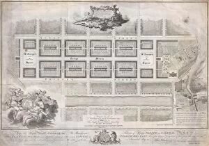
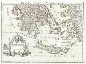
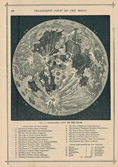
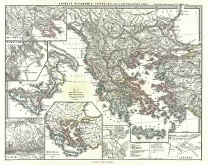
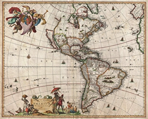
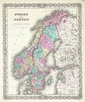
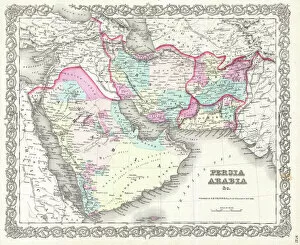
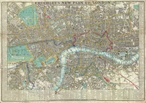
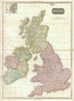
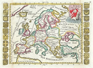
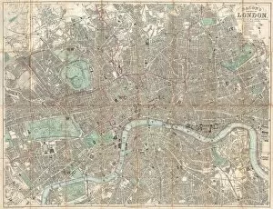
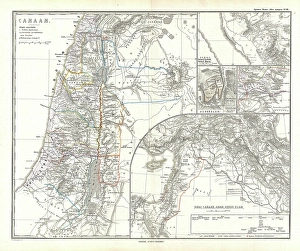
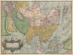
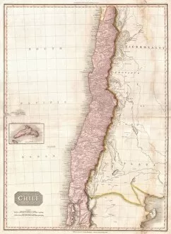
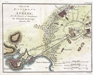
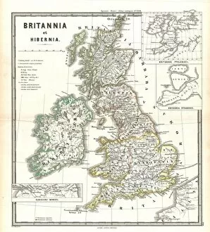
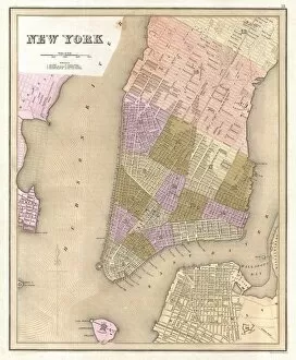
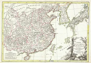
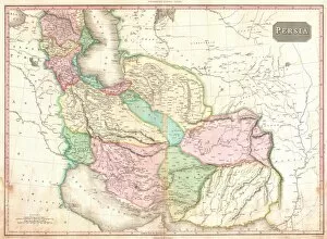
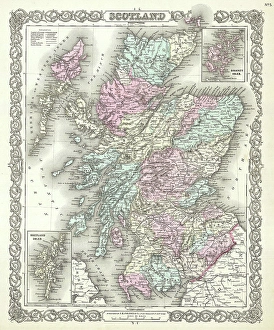
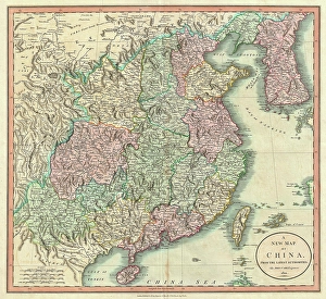
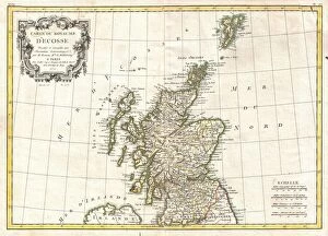
"Unveiling the Treasures: Rare Old Maps that Unearth Centuries of History" Step into a time machine and embark on a captivating journey through centuries past with these rare old maps. Dating back to 1768, the James Craig Map of New Town in Edinburgh, Scotland offers an intriguing glimpse into the city's architectural evolution. Meanwhile, the Delisle Map of Southern Ancient Greece from 1794 takes us on a mesmerizing exploration of Greek Isles and Crete. For lunar enthusiasts, the Telescopic View and Map of the Moon from 1886 presents an awe-inspiring depiction of our celestial neighbor's topography. As we delve further into cartography wonders, we encounter Visscher's remarkable 1658 map showcasing North America and South America's diverse landscapes. The Colton Map of Scandinavia from 1855 invites us to marvel at Norway, Sweden, Finland’s majestic beauty while Spruner's detailed map transports us back to ancient Greece, Macedonia, and Thrace before the Peloponnesian War in 1865. Londoners can navigate their city across time with Crutchley Pocket Map or Plan dating back to 1848. British history aficionados will relish Pinkerton’s meticulously crafted map depicting England, Scotland, Ireland - a true gem from 1818. The Colton Map reveals Persia’s enchanting terrain along with Afghanistan and Arabia in all their glory during this era. Traveling even further back in time brings us face-to-face with De La Feuille’s stunningly illustrated landmasses comprising Europe circa1706. Lastly but not leastly is Bacon Traveler Pocket Map offering an invaluable guide for navigating London streets as it stood in1890. These they can more than just geographical representations; they encapsulate historical narratives waiting to be unraveled by curious minds like yours. Immerse yourself in these timeless treasures that bridge continents and centuries, and let your imagination soar.