Home > Europe > Iceland > Maps
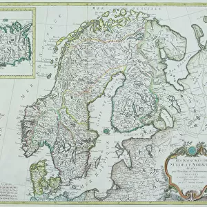
1840, Lizars Map of Scandinavia, Norway, Sweden, Finland, Denmark, Iceland, topography

![]()
Wall Art and Photo Gifts from Liszt Collection
1840, Lizars Map of Scandinavia, Norway, Sweden, Finland, Denmark, Iceland, topography
1840, Lizars Map of Scandinavia, Norway, Sweden, Finland, Denmark, Iceland
Liszt Collection of nineteenth-century engravings and images to browse and enjoy
Media ID 14005088
© Artokoloro Quint Lox Limited
1840 Denmark Finland Iceland Norway Sweden Antique Map Atlas Chart Geographic Latitude Longitude Mappa Mundi Old Antique Plan Old Antique View Old Map Ols Antique Map Rare Old Maps Topo
FEATURES IN THESE COLLECTIONS
> Maps and Charts
> Early Maps
EDITORS COMMENTS
This vintage print from the Liszt Collection showcases an exquisite map of Scandinavia, capturing the essence of 1840's cartography. The intricate details and topographical accuracy make it a remarkable piece for geography enthusiasts and history buffs alike. Spanning across Norway, Sweden, Finland, Denmark, and Iceland, this map beautifully illustrates the diverse landscapes and geographical features of these Nordic countries. The artistry behind this ancient map is evident in its meticulous depiction of landforms, including mountains, rivers, and coastlines. With its grid lines indicating latitude and longitude coordinates, it serves as a valuable tool for navigation or studying historical journeys of exploration in the region. Printed on aged paper with a touch of retro charm, this decorative piece transports us back to an era when maps were not just functional tools but also works of art. Its presence adds a sense of nostalgia to any space while evoking curiosity about past civilizations' understanding of our world. Whether you are an avid traveler seeking inspiration or a collector fascinated by rare old maps, this Lizars Map offers both historical significance and aesthetic appeal. It invites viewers to embark on their own journey through time as they explore the rich heritage encapsulated within its borders.
MADE IN THE UK
Safe Shipping with 30 Day Money Back Guarantee
FREE PERSONALISATION*
We are proud to offer a range of customisation features including Personalised Captions, Color Filters and Picture Zoom Tools
SECURE PAYMENTS
We happily accept a wide range of payment options so you can pay for the things you need in the way that is most convenient for you
* Options may vary by product and licensing agreement. Zoomed Pictures can be adjusted in the Basket.