Framed Print > Asia > Turkey > Related Images
Framed Print : The Balkan States After the Wars of 1912-13, (c1920). Creator: John Bartholomew & Son
. Creator: John Bartholomew & Son")


. Creator: John Bartholomew & Son")


![]()
Framed Photos from Heritage Images
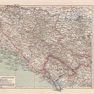
The Balkan States After the Wars of 1912-13, (c1920). Creator: John Bartholomew & Son
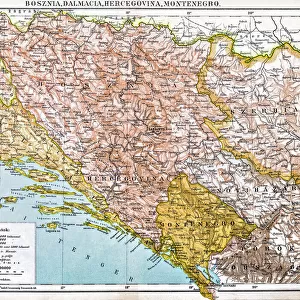
The Balkan States After the Wars of 1912-13, (c1920). Showing Acquisitions of Territory in Darker Tints. Map of the Balkans: Bosnia, Montenegro, Servia (Serbia), Albania, Roumania (Romania), Bulgaria, Greece and part of Turkey, with the Adriatic, Ionian and Aegean seas. From " The Great World War - A History" Volume IV, edited by Frank A Mumby. [The Gresham Publishing Company Ltd, London, c1920]
Heritage Images features heritage image collections
Media ID 19174517
© The Print Collector/Heritage Images
Adriatic Aegean Sea Albania Balkans Bartholomew Bartholomew And Co Bartholomew Co Bartholomew John Son Bulgaria Frank Arthur Frank Arthur Mumby Gresham Publishing Co Ltd Gresham Publishing Company Ionian Sea Jg Bartholomew John And Son John Bartholomew And Co John Bartholomew And Son John Bartholomew And Son Ltd John Bartholomew Co John Bartholomew Son John Bartholomew Son Ltd John Son Keystone Archives Mediterranean Sea Montenegro Mumby Mumby Frank Arthur Romania Serbia The Great World War A History Theatre Of War Turkey Turkish Yugoslavia
14"x12" (38x32cm) Modern Frame
Step back in time with our vintage Framed Print of "The Balkan States After the Wars of 1912-13" by John Bartholomew & Son from Heritage Images. This captivating map, dated circa 1920, showcases the acquisitions of territory in the Balkan region following the Balkan Wars of 1912-13. Bosnia, Montenegro, Servia (Serbia), Albania, and Roumania (Romania) are all represented in this intricately detailed and historically significant piece. Perfect for history enthusiasts, world travelers, or anyone seeking to add a touch of nostalgia to their home or office decor. This Framed Print is not just a map, but a journey through time.
Wood effect frame, card mounted, 10x8 archival quality photo print. Overall outside dimensions 14x12 inches (38x32cm). Environmentally and ozone friendly, 40mm wide x 15mm Polycore® moulding has the look of real wood, is durable and light and easy to hang. Biodegradable and made with non-chlorinated gases (no toxic fumes) it is efficient; producing 100 tons of polystyrene can save 300 tons of trees! Prints are glazed with lightweight, shatterproof, optical clarity acrylic (providing the same general protection from the environment as glass). The back is stapled hardboard with a sawtooth hanger attached. Note: To minimise original artwork cropping, for optimum layout, and to ensure print is secure, the visible print may be marginally smaller
Contemporary Framed and Mounted Prints - Professionally Made and Ready to Hang
Estimated Image Size (if not cropped) is 18.2cm x 24.4cm (7.2" x 9.6")
Estimated Product Size is 32.5cm x 37.6cm (12.8" x 14.8")
These are individually made so all sizes are approximate
Artwork printed orientated as per the preview above, with portrait (vertical) orientation to match the source image.
FEATURES IN THESE COLLECTIONS
> Asia
> Turkey
> Related Images
> Europe
> Albania
> Related Images
> Europe
> Bosnia and Herzegovina
> Maps
> Europe
> Bulgaria
> Related Images
EDITORS COMMENTS
The Balkan States After the Wars of 1912-13, (c1920). Creator: John Bartholomew & Son This print showcases a map titled 'The Balkan States After the Wars of 1912-13', created by John Bartholomew & Son in the early 1920s. The map depicts the acquisitions of territory in darker tints, providing a visual representation of the significant changes that occurred in this tumultuous region. Covering Bosnia, Montenegro, Servia (Serbia), Albania, Roumania (Romania), Bulgaria, Greece and part of Turkey, with the Adriatic, Ionian and Aegean seas beautifully outlined; this map offers an invaluable insight into the complex geopolitical landscape following World War I. As one delves into its details, it becomes evident that each country's borders have been meticulously marked to reflect their territorial gains during these wars. This historical artifact serves as a testament to both triumph and loss for nations involved. With its vibrant colors and precise cartography techniques employed by John Bartholomew & Son Ltd. , this print is not only visually striking but also holds immense educational value. It allows us to understand how conflicts shape landscapes and redraw political boundaries. Preserved within 'The Great World War - A History' Volume IV edited by Frank A Mumby from The Gresham Publishing Company Ltd. , London; this image stands as a reminder of our ever-evolving world. It captures a specific moment in time when countries were reshaping themselves amidst global turmoil. Through this photograph print from Heritage Images curated by John Bartholomew & Son Ltd. , we are transported back to an era where war redefined nations.
MADE IN THE UK
Safe Shipping with 30 Day Money Back Guarantee
FREE PERSONALISATION*
We are proud to offer a range of customisation features including Personalised Captions, Color Filters and Picture Zoom Tools
SECURE PAYMENTS
We happily accept a wide range of payment options so you can pay for the things you need in the way that is most convenient for you
* Options may vary by product and licensing agreement. Zoomed Pictures can be adjusted in the Basket.