Home > Europe > Italy > Maps
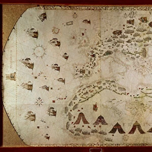
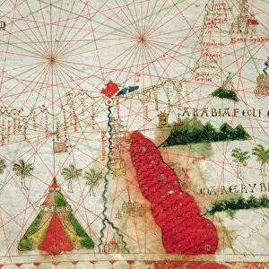
Mediterranean coast, from the Portolan Charts by Francesco Oliva, printed in Italy, 1611

![]()
Wall Art and Photo Gifts from Universal Images Group (UIG)
Mediterranean coast, from the Portolan Charts by Francesco Oliva, printed in Italy, 1611
Cartography, 17th century. Mediterranean coast. From the Portolan Charts by Francesco Oliva, 1611
Universal Images Group (UIG) manages distribution for many leading specialist agencies worldwide
Media ID 9570437
© DEA / A. DAGLI ORTI
17th Century Camel Coastline Direction Guidance Mediterranean Sea Western Script Wind Rose
FEATURES IN THESE COLLECTIONS
> Europe
> Italy
> Sculptures
> Universal Images Group (UIG)
> Art
> Painting, Sculpture & Prints
> Cartography
EDITORS COMMENTS
This stunning print captures the mesmerizing beauty of the Mediterranean coast, as depicted in Francesco Oliva's Portolan Charts from 1611. The intricate details and precision of this 17th-century map showcase the artistry and skill of cartography during that era. The image showcases a vast expanse of the Mediterranean Sea, stretching out towards the horizon with its deep blue hues. The coastline is meticulously outlined, highlighting various landmarks along its path. A wind rose elegantly adorns one corner, symbolizing direction and guidance for travelers navigating these waters. Intriguingly, a solitary camel gracefully stands on the shore, adding an unexpected touch to this historical depiction. Its presence hints at ancient trade routes and travel across these lands centuries ago. This horizontal print beautifully combines illustration and painting techniques to create a visual masterpiece that transports viewers back in time. With no people present in the scene, it allows us to focus solely on nature's grandeur and appreciate the immense history associated with this region. Whether you are fascinated by physical geography or simply captivated by art and craft from centuries past, this print offers a captivating glimpse into both worlds. It serves as a reminder of our connection to history while igniting wanderlust for those who dream of exploring these enchanting shores firsthand.
MADE IN THE UK
Safe Shipping with 30 Day Money Back Guarantee
FREE PERSONALISATION*
We are proud to offer a range of customisation features including Personalised Captions, Color Filters and Picture Zoom Tools
SECURE PAYMENTS
We happily accept a wide range of payment options so you can pay for the things you need in the way that is most convenient for you
* Options may vary by product and licensing agreement. Zoomed Pictures can be adjusted in the Basket.