Home > Europe > Italy > Maps
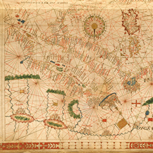
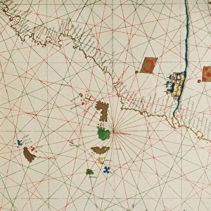
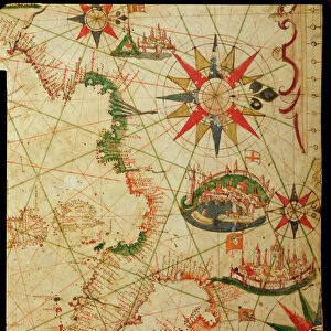
Portolan chart by Jacopo Maggiolo, 1561

![]()
Wall Art and Photo Gifts from Universal Images Group (UIG)
Portolan chart by Jacopo Maggiolo, 1561
Cartography, Italy, 16th century. Portolan chart by Jacopo Maggiolo, 1561
Universal Images Group (UIG) manages distribution for many leading specialist agencies worldwide
Media ID 9570521
© DEA PICTURE LIBRARY
16th Century Chart Geography Tent Portolan
FEATURES IN THESE COLLECTIONS
> Europe
> Italy
> Sculptures
> Universal Images Group (UIG)
> Art
> Painting, Sculpture & Prints
> Cartography
EDITORS COMMENTS
This print showcases a remarkable piece of cartographic history - the Portolan chart by Jacopo Maggiolo, dating back to 1561. Hailing from Italy and created during the vibrant 16th century, this exquisite map offers a fascinating glimpse into the world of navigation and exploration during that era. The intricate pattern displayed on this chart is a testament to Maggiolo's meticulous craftsmanship. With its detailed topography and precise geographical markings, it served as an invaluable tool for sailors seeking to navigate their way across vast oceans. The horizontal layout allows viewers to immerse themselves in the rich tapestry of information presented before them. Intriguingly, there are no people depicted within this illustration and painting. Instead, all attention is focused solely on the artistry of cartography itself. This absence only serves to enhance our appreciation for Maggiolo's skillful execution and dedication to his craft. The presence of a tent-like structure adds an element of intrigue and adventure to the scene captured in this photograph. It sparks curiosity about how these maps were utilized by explorers who embarked on perilous journeys into uncharted territories centuries ago. Overall, this extraordinary portolan chart transports us back in time, allowing us to marvel at both its artistic beauty and historical significance. Its enduring appeal lies not only in its practicality but also in its ability to ignite our imagination as we ponder upon the countless voyages undertaken with such charts as guides through unexplored waters.
MADE IN THE UK
Safe Shipping with 30 Day Money Back Guarantee
FREE PERSONALISATION*
We are proud to offer a range of customisation features including Personalised Captions, Color Filters and Picture Zoom Tools
SECURE PAYMENTS
We happily accept a wide range of payment options so you can pay for the things you need in the way that is most convenient for you
* Options may vary by product and licensing agreement. Zoomed Pictures can be adjusted in the Basket.