Home > Arts > Artists > P > Pietro Giovanni Prunes
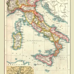
The Atlantic coasts of Europe and the Western Mediterranean, from a nautical atlas

![]()
Wall Art and Photo Gifts from Fine Art Finder
The Atlantic coasts of Europe and the Western Mediterranean, from a nautical atlas
XOT330919 The Atlantic coasts of Europe and the Western Mediterranean, from a nautical atlas, 1651 (ink on vellum) (see also ) by Pietro Giovanni Prunes (fl. 17th Century); 41.6x28 cm; Museo Correr, Venice, Italy; Italian, out of copyright
Media ID 12852575
© www.bridgemanart.com
Balearic Islands Camel Camels Cartography Chart Cities Compass Corsica Elephant Iberian Peninsula Mapping Portolan Portugal Sardinia
FEATURES IN THESE COLLECTIONS
> Africa
> Related Images
> Animals
> Farm
> Horses
> Related Images
> Animals
> Mammals
> Cats (Wild)
> Lion
> Animals
> Mammals
> Horse
> Related Images
> Arts
> Artists
> P
> Pietro Giovanni Prunes
> Europe
> Italy
> Sardinia
> Related Images
> Europe
> Italy
> Veneto
> Venice
> Fine Art Finder
> Artists
> P
> Pietro Giovanni Prunes Pietro Giovanni
> Fine Art Finder
> Artists
> Pietro Giovanni Prunes
> Fine Art Finder
> Maps (celestial & Terrestrial)
EDITORS COMMENTS
This print showcases "The Atlantic coasts of Europe and the Western Mediterranean" as depicted in a nautical atlas created by Pietro Giovanni Prunes in 1651. The intricate details of this ink on vellum artwork transport us back to a time when cartography was both an art form and a vital tool for seafarers. Measuring 41.6x28 cm, this historical piece is housed in the Museo Correr located in Venice, Italy. It captures the essence of various European countries including the Iberian Peninsula, France, Spain, Portugal, England, Scotland, and Ireland. Additionally, it encompasses parts of North Africa along with notable islands such as Balearic Islands, Corsica, and Sardinia. As we explore this map's rich imagery further, we encounter fascinating elements that bring life to its pages. From compasses guiding sailors through treacherous waters to depictions of majestic animals like camels traversing desert landscapes or lions roaming African plains - every detail tells a story. Cities are marked with precision throughout the map; bustling hubs where trade flourished and cultures converged. Furthermore, one cannot miss the presence of magnificent creatures like elephants and horses that symbolize power and strength. This extraordinary piece offers not only geographical insights but also glimpses into an era defined by exploration and discovery. Its beauty lies not just in its accuracy but also in its ability to evoke curiosity about our shared history.
MADE IN THE UK
Safe Shipping with 30 Day Money Back Guarantee
FREE PERSONALISATION*
We are proud to offer a range of customisation features including Personalised Captions, Color Filters and Picture Zoom Tools
SECURE PAYMENTS
We happily accept a wide range of payment options so you can pay for the things you need in the way that is most convenient for you
* Options may vary by product and licensing agreement. Zoomed Pictures can be adjusted in the Basket.