Ile-de-France, France, satellite image

![]()
Wall Art and Photo Gifts from Science Photo Library
Ile-de-France, France, satellite image
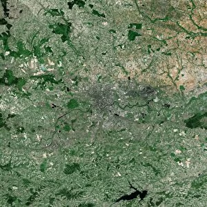
Ile-de-France, France. North is at top. Natural colour satellite image of a close-up on the Ile-de-France administrative region of France, showing Paris (lower left) and the departments of Seine-Saint-Denis (centre), Seine-et-Marne (right), Val-de-Marne, (bottom centre), Hauts-de-Seine (bottom left), and Val-d Oise (top left). France is located in Western Europe. Paris is the capital and largest city of France. Bot it and Seine-Saint-Denis are located in northern France, at the heart of the Ile-de-France region. Image compiled from data acquired by the LANDSAT 5 and 7 satellites, in 2000. Images highlighting all other regions of this country are available. For further information please contact SPL
Science Photo Library features Science and Medical images including photos and illustrations
Media ID 9215797
© PLANETOBSERVER/SCIENCE PHOTO LIBRARY
2000 Administrative Region Birds Eye View Border Borders Boundaries Boundary Capital City Cartography Countries Country Department Earth Observation Environmental France French From Above From Space Frontier Frontiers Land Landsat 5 Landsat 7 Nation Natural Colour North Northern Paris Region Regions Satellite Satellite Image Topographic Topography Western Europe Departments Hauts De Seine Ile De France Seine Et Marne Seine Saint Denis Val De Marne Val Doise
EDITORS COMMENTS
This satellite image showcases the stunning Ile-de-France administrative region of France, with Paris taking center stage in the lower left corner. The natural color photograph, taken from space by the LANDSAT 5 and 7 satellites in 2000, provides a bird's eye view of this enchanting part of Western Europe. The photo highlights various departments within Ile-de-France, including Seine-Saint-Denis at the heart of the region. As we explore further, we can also spot Seine-et-Marne to the right, Val-de-Marne in the bottom center, Hauts-de-Seine in the bottom left, and Val-d'Oise in the top left. France's capital city and largest metropolis, Paris exudes its timeless charm as it gracefully sprawls across this picturesque landscape. The intricate network of borders and boundaries between these regions adds to their unique character. With its rich history and cultural significance, Ile-de-France is a treasure trove for both locals and tourists alike. This satellite image not only captures its geographical features but also offers valuable insights into its topography and environmental diversity. As an awe-inspiring testament to our technological advancements in earth observation during the 21st century, this print serves as a reminder of how far we have come. For those seeking more information or interested in exploring other regions within France through similar images highlighting their distinctiveness—look no further than Science Photo Library!
MADE IN THE UK
Safe Shipping with 30 Day Money Back Guarantee
FREE PERSONALISATION*
We are proud to offer a range of customisation features including Personalised Captions, Color Filters and Picture Zoom Tools
SECURE PAYMENTS
We happily accept a wide range of payment options so you can pay for the things you need in the way that is most convenient for you
* Options may vary by product and licensing agreement. Zoomed Pictures can be adjusted in the Basket.