Home > Arts > Artists > S > John Speed
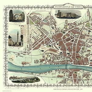
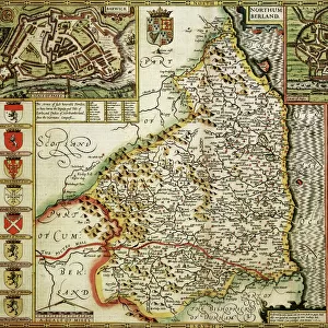
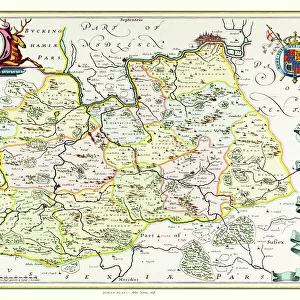
Old County Map of Northumberland 1611 by John Speed

![]()
Wall Art and Photo Gifts from MapSeeker
Old County Map of Northumberland 1611 by John Speed
A facimile of John Speeds historical map of Northumberland originally published for the " Theatre of the Empire of Great Britain", an atlas to accompany " a history of Great Britain"
Welcome to the Mapseeker Image library and enter an historic gateway to one of the largest on-line collections of Historic Maps, Nostalgic Views, Vista's and Panorama's from a World gone by.
Media ID 20347939
© Mapseeker Publishing Ltd
County Map County Map Of England English County Map Historic Map John Speed Map Old County Map Old English County Map Speed Map Speede Map Northumberland
FEATURES IN THESE COLLECTIONS
> Arts
> Artists
> S
> John Speed
> Europe
> United Kingdom
> England
> Maps
> Europe
> United Kingdom
> England
> Northumberland
> Related Images
> Maps and Charts
> British Empire Maps
> Maps and Charts
> Early Maps
> Maps and Charts
> Related Images
> MapSeeker
> Maps from the British Isles
> England and Counties PORTFOLIO
EDITORS COMMENTS
This stunning print showcases the "Old County Map of Northumberland 1611" by John Speed, a renowned cartographer of his time. Originally published for the "Theatre of the Empire of Great Britain" an atlas accompanying a comprehensive history of Great Britain, this facsimile captures the intricate details and historical significance of Speed's work. As you gaze upon this old English county map, you are transported back in time to 17th-century Northumberland. Every line and contour on this meticulously crafted map tells a story, revealing the rich heritage and geography of this ancient county. From its rugged coastline to its rolling hills and picturesque villages, every corner is beautifully depicted with remarkable accuracy. John Speed's expertise as a cartographer shines through in this historic masterpiece. His attention to detail is evident as he intricately maps out towns, rivers, forests, and even individual buildings. This map not only serves as an invaluable resource for historians but also offers a glimpse into how people perceived their world centuries ago. Whether you have personal ties to Northumberland or simply appreciate historical artifacts, this print will undoubtedly captivate your imagination. Hang it proudly on your wall or gift it to someone who shares your passion for history – either way; it promises to be a conversation starter that transports you back in time to explore the enchanting landscapes and stories held within Northumberland's borders.
MADE IN THE UK
Safe Shipping with 30 Day Money Back Guarantee
FREE PERSONALISATION*
We are proud to offer a range of customisation features including Personalised Captions, Color Filters and Picture Zoom Tools
SECURE PAYMENTS
We happily accept a wide range of payment options so you can pay for the things you need in the way that is most convenient for you
* Options may vary by product and licensing agreement. Zoomed Pictures can be adjusted in the Basket.