Home > Arts > Artists > H > Jodocus Hondius
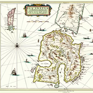
Old County Map of Gloucestershire 1648 by Johan Blaeu from the Atlas Novus

![]()
Wall Art and Photo Gifts from MapSeeker
Old County Map of Gloucestershire 1648 by Johan Blaeu from the Atlas Novus
This detailed and most attractive reproduction map of Gloucestershire has been carefully art worked from a scan of an antique original. The famous firm of Dutch cartographers and publishers was established in the late 16th century by Willem Janszoon Blaeu in Amsterdam. Blaeu was a maker of globes and scientific instruments and purchased some of his early map plates from Jodocus Hondius. From this small beginning was to emerge one of the largest and most prolific map publishing houses of the seventeenth century
Welcome to the Mapseeker Image library and enter an historic gateway to one of the largest on-line collections of Historic Maps, Nostalgic Views, Vista's and Panorama's from a World gone by.
Media ID 20347838
Blaeu Blaeu Family County Map County Map Of England English County Map Historic Map Johan Blaeu Johan Blaeu Map Old Blaue Map Old County Map Old English County Map Gloucestershire
FEATURES IN THESE COLLECTIONS
> Arts
> Artists
> B
> Willem Blaeu
> Arts
> Artists
> H
> Jodocus Hondius
> Arts
> Photorealistic artworks
> Detailed art pieces
> Masterful detailing in art
> Europe
> United Kingdom
> England
> Gloucestershire
> Related Images
> Europe
> United Kingdom
> England
> Maps
> Maps and Charts
> Early Maps
> Maps and Charts
> Willem Janszoon Blaeu
> MapSeeker
> Maps from the British Isles
> England and Counties PORTFOLIO
EDITORS COMMENTS
This stunning reproduction of the "Old County Map of Gloucestershire 1648" by Johan Blaeu takes us back in time to explore the rich history and intricate details of this English county. Carefully art worked from a scan of an antique original, this map showcases the exceptional craftsmanship and expertise of the famous Dutch cartographer. Established in Amsterdam during the late 16th century by Willem Janszoon Blaeu, this renowned firm initially focused on globe-making and scientific instruments before venturing into map publishing. Acquiring some map plates from Jodocus Hondius, Blaeu's enterprise grew rapidly, eventually becoming one of the largest and most prolific map publishing houses of the seventeenth century. The captivating beauty and historical significance captured within this old county map are truly remarkable. From its elegant design to its meticulous depiction of towns, rivers, forests, and landmarks across Gloucestershire, every detail transports us to a bygone era. This historic piece not only serves as a valuable resource for researchers but also appeals to those with an appreciation for vintage maps or anyone curious about their ancestral roots in Gloucestershire. Whether you're fascinated by cartography or simply intrigued by England's past, this authentic reproduction offers a glimpse into centuries-old geography while adding an air of sophistication to any space it graces. Immerse yourself in history with this exquisite print that pays homage to both Johan Blaeu's legacy as well as Gloucestershire's vibrant heritage.
MADE IN THE UK
Safe Shipping with 30 Day Money Back Guarantee
FREE PERSONALISATION*
We are proud to offer a range of customisation features including Personalised Captions, Color Filters and Picture Zoom Tools
SECURE PAYMENTS
We happily accept a wide range of payment options so you can pay for the things you need in the way that is most convenient for you
* Options may vary by product and licensing agreement. Zoomed Pictures can be adjusted in the Basket.