Home > Arts > Artists > S > John Speed
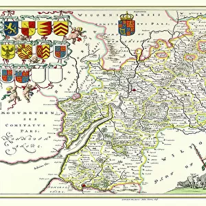
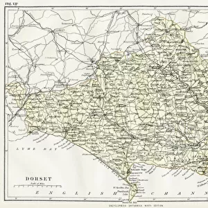
Old County Map of Dorsetshire 1611 by John Speed

![]()
Wall Art and Photo Gifts from MapSeeker
Old County Map of Dorsetshire 1611 by John Speed
A facimile of John Speeds historical map of Dorsetshire originally published for the " Theatre of the Empire of Great Britain", an atlas to accompany " a history of Great Britain"
Welcome to the Mapseeker Image library and enter an historic gateway to one of the largest on-line collections of Historic Maps, Nostalgic Views, Vista's and Panorama's from a World gone by.
Media ID 20348152
© Mapseeker Publishing Ltd
County Map County Map Of England English County Map Historic Map John Speed Map Old County Map Old English County Map Speed Map Speede Map Dorset Dorsetshire
FEATURES IN THESE COLLECTIONS
> Arts
> Artists
> S
> John Speed
> Europe
> United Kingdom
> England
> Dorset
> Related Images
> Europe
> United Kingdom
> England
> Maps
> Maps and Charts
> British Empire Maps
> Maps and Charts
> Early Maps
> Maps and Charts
> Related Images
> MapSeeker
> Maps from the British Isles
> England and Counties PORTFOLIO
EDITORS COMMENTS
This print showcases the "Old County Map of Dorsetshire 1611" by John Speed, a renowned cartographer of his time. Originally published for the "Theatre of the Empire of Great Britain" an atlas accompanying a comprehensive history of Great Britain, this facsimile allows us to delve into the rich historical tapestry of Dorsetshire. The map itself is a testament to Speed's meticulous craftsmanship and attention to detail. Every contour, river, and village is intricately depicted, offering us a glimpse into what life was like in this English county over four centuries ago. As we explore its intricate lines and delicate illustrations, we can almost hear echoes from the past whispering tales of forgotten times. Dorsetshire unfolds before our eyes as we trace its ancient boundaries and discover its hidden treasures. From bustling market towns to idyllic countryside landscapes, every corner holds secrets waiting to be unraveled. This historic map not only serves as a geographical reference but also invites us on an immersive journey through time. Whether you are an avid historian or simply captivated by the beauty of old maps, this print transports you back in time with its authentic charm. It proudly stands as a tribute to John Speed's legacy and reminds us that beneath our modern world lies layers upon layers of history just waiting to be explored.
MADE IN THE UK
Safe Shipping with 30 Day Money Back Guarantee
FREE PERSONALISATION*
We are proud to offer a range of customisation features including Personalised Captions, Color Filters and Picture Zoom Tools
SECURE PAYMENTS
We happily accept a wide range of payment options so you can pay for the things you need in the way that is most convenient for you
* Options may vary by product and licensing agreement. Zoomed Pictures can be adjusted in the Basket.