Fine Art Print > Arts > Artists > S > John Speed
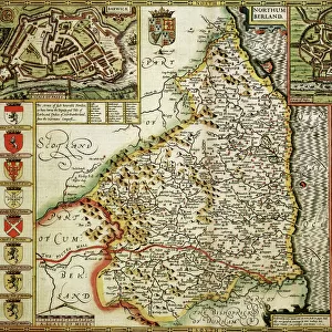
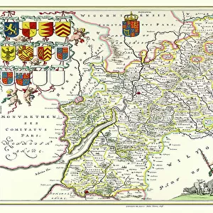
Fine Art Print : Old County Map of Northumberland 1611 by John Speed


![]()
Fine Art Prints from MapSeeker
Old County Map of Northumberland 1611 by John Speed
A facimile of John Speeds historical map of Northumberland originally published for the " Theatre of the Empire of Great Britain", an atlas to accompany " a history of Great Britain"
Welcome to the Mapseeker Image library and enter an historic gateway to one of the largest on-line collections of Historic Maps, Nostalgic Views, Vista's and Panorama's from a World gone by.
Media ID 20347939
© Mapseeker Publishing Ltd
County Map County Map Of England English County Map Historic Map John Speed Map Old County Map Old English County Map Speed Map Speede Map Northumberland
A2 (42x59cm) Fine Art Print
Step back in time with our exquisite Old County Map of Northumberland 1611 by John Speed from our Media Storehouse Fine Art Prints collection. This captivating reproduction, taken from the original map published for the "Theatre of the Empire of Great Britain," transports you to an era of historical significance. John Speed's intricate cartography showcases the rich details of Northumberland's landscapes and borders, making it a stunning addition to any home or office. Bring history to life with this beautiful, museum-quality print.
Our Fine Art Prints are printed on 100% acid free, PH neutral paper with archival properties. This printing method is used by museums and art collections to exhibit photographs and art reproductions. Hahnemühle certified studio for digital fine art printing. Printed on 308gsm Photo Rag Paper.
Our fine art prints are high-quality prints made using a paper called Photo Rag. This 100% cotton rag fibre paper is known for its exceptional image sharpness, rich colors, and high level of detail, making it a popular choice for professional photographers and artists. Photo rag paper is our clear recommendation for a fine art paper print. If you can afford to spend more on a higher quality paper, then Photo Rag is our clear recommendation for a fine art paper print.
Estimated Image Size (if not cropped) is 59.4cm x 39.6cm (23.4" x 15.6")
Estimated Product Size is 59.4cm x 42cm (23.4" x 16.5")
These are individually made so all sizes are approximate
Artwork printed orientated as per the preview above, with landscape (horizontal) orientation to match the source image.
FEATURES IN THESE COLLECTIONS
> Arts
> Artists
> S
> John Speed
> Europe
> United Kingdom
> England
> Maps
> Europe
> United Kingdom
> England
> Northumberland
> Related Images
> Maps and Charts
> British Empire Maps
> Maps and Charts
> Early Maps
> Maps and Charts
> Related Images
> MapSeeker
> Maps from the British Isles
> England and Counties PORTFOLIO
EDITORS COMMENTS
This stunning print showcases the "Old County Map of Northumberland 1611" by John Speed, a renowned cartographer of his time. Originally published for the "Theatre of the Empire of Great Britain" an atlas accompanying a comprehensive history of Great Britain, this facsimile captures the intricate details and historical significance of Speed's work. As you gaze upon this old English county map, you are transported back in time to 17th-century Northumberland. Every line and contour on this meticulously crafted map tells a story, revealing the rich heritage and geography of this ancient county. From its rugged coastline to its rolling hills and picturesque villages, every corner is beautifully depicted with remarkable accuracy. John Speed's expertise as a cartographer shines through in this historic masterpiece. His attention to detail is evident as he intricately maps out towns, rivers, forests, and even individual buildings. This map not only serves as an invaluable resource for historians but also offers a glimpse into how people perceived their world centuries ago. Whether you have personal ties to Northumberland or simply appreciate historical artifacts, this print will undoubtedly captivate your imagination. Hang it proudly on your wall or gift it to someone who shares your passion for history – either way; it promises to be a conversation starter that transports you back in time to explore the enchanting landscapes and stories held within Northumberland's borders.
MADE IN THE UK
Safe Shipping with 30 Day Money Back Guarantee
FREE PERSONALISATION*
We are proud to offer a range of customisation features including Personalised Captions, Color Filters and Picture Zoom Tools
SECURE PAYMENTS
We happily accept a wide range of payment options so you can pay for the things you need in the way that is most convenient for you
* Options may vary by product and licensing agreement. Zoomed Pictures can be adjusted in the Basket.