Home > Arts > Artists > S > John Speed
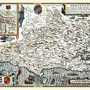
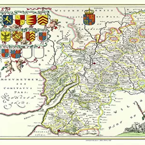
Old County Map of Gloucestershire 1611 by John Speed

![]()
Wall Art and Photo Gifts from MapSeeker
Old County Map of Gloucestershire 1611 by John Speed
A facimile of John Speeds historical map of Gloucestershire originally published for the " Theatre of the Empire of Great Britain", an atlas to accompany " a history of Great Britain"
Welcome to the Mapseeker Image library and enter an historic gateway to one of the largest on-line collections of Historic Maps, Nostalgic Views, Vista's and Panorama's from a World gone by.
Media ID 20347802
© Mapseeker Publishing Ltd
County Map English County Map Historic Map John Speed Map Old County Map Old English County Map Speed Map Speede Map
FEATURES IN THESE COLLECTIONS
> Arts
> Artists
> S
> John Speed
> Europe
> United Kingdom
> England
> Gloucestershire
> Related Images
> Maps and Charts
> British Empire Maps
> Maps and Charts
> Early Maps
> Maps and Charts
> Related Images
> MapSeeker
> Maps from the British Isles
> England and Counties PORTFOLIO
EDITORS COMMENTS
This print showcases the exquisite "Old County Map of Gloucestershire 1611" by the renowned cartographer, John Speed. Originally published for his esteemed work, "The Theatre of the Empire of Great Britain" this facsimile offers a glimpse into the rich history and geography of Gloucestershire. As you delve into this ancient English county map, intricately designed with meticulous attention to detail, you are transported back in time to the early 17th century. Every line and curve on this historic map tells a story, revealing towns, villages, rivers, and landmarks that have shaped Gloucestershire's past. John Speed's expertise as a cartographer is evident through his precise representation of boundaries and topographical features. This masterpiece serves not only as an invaluable resource for historians but also as a stunning piece of art that captures the essence of Gloucestershire's heritage. With its faded hues and delicate textures preserved in this print reproduction, it becomes an enchanting addition to any collection or display. Whether you are fascinated by old maps or simply wish to explore your ancestral roots in Gloucestershire, this John Speed map provides an immersive experience like no other. Allow yourself to be captivated by the historical significance encapsulated within every inch of this remarkable artwork – a testament to both John Speed's skill as a cartographer and Gloucestershire's enduring legacy throughout centuries gone by.
MADE IN THE UK
Safe Shipping with 30 Day Money Back Guarantee
FREE PERSONALISATION*
We are proud to offer a range of customisation features including Personalised Captions, Color Filters and Picture Zoom Tools
SECURE PAYMENTS
We happily accept a wide range of payment options so you can pay for the things you need in the way that is most convenient for you
* Options may vary by product and licensing agreement. Zoomed Pictures can be adjusted in the Basket.