Home > Arts > Artists > S > John Speed
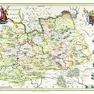
Old County Map of Lancashire 1611 by John Speed

![]()
Wall Art and Photo Gifts from MapSeeker
Old County Map of Lancashire 1611 by John Speed
A facimile of John Speeds historical map of Lancashire published for the " Theatre of the Empire of Great Britain", an atlas to accompany " a history of Great Britain"
Welcome to the Mapseeker Image library and enter an historic gateway to one of the largest on-line collections of Historic Maps, Nostalgic Views, Vista's and Panorama's from a World gone by.
Media ID 20347820
© Mapseeker Publishing Ltd
County Map County Map Of England English County Map Historic Map John Speed Map Old County Map Old English County Map Speed Map Speede Map Lancashire
FEATURES IN THESE COLLECTIONS
> Arts
> Artists
> S
> John Speed
> Europe
> United Kingdom
> England
> Lancashire
> Related Images
> Europe
> United Kingdom
> England
> Maps
> Maps and Charts
> British Empire Maps
> Maps and Charts
> Early Maps
> Maps and Charts
> Related Images
> MapSeeker
> Maps from the British Isles
> England and Counties PORTFOLIO
EDITORS COMMENTS
This print showcases the "Old County Map of Lancashire 1611" by John Speed, a renowned cartographer of his time. Published as part of the "Theatre of the Empire of Great Britain" an atlas accompanying a comprehensive history of Great Britain, this facsimile offers a glimpse into the rich historical landscape of Lancashire. With its intricate details and elegant design, this English county map provides an invaluable resource for historians and enthusiasts alike. The map's vintage charm transports us back to a bygone era, where Lancashire's boundaries were defined differently than they are today. It serves as a testament to John Speed's exceptional skill in capturing geographical accuracy while infusing artistic flair. As we explore this historic Lancashire map, we can trace the contours of rivers snaking through lush landscapes, identify towns and villages that have stood the test of time, and uncover forgotten landmarks that once shaped local communities. This visual depiction allows us to immerse ourselves in centuries-old stories woven into every inch. Whether you're tracing your family roots or simply fascinated by cartographic treasures from yesteryears, this old county map is sure to captivate your imagination. Let it transport you on a journey through time as you unravel Lancashire's past and appreciate how geography has evolved over centuries.
MADE IN THE UK
Safe Shipping with 30 Day Money Back Guarantee
FREE PERSONALISATION*
We are proud to offer a range of customisation features including Personalised Captions, Color Filters and Picture Zoom Tools
SECURE PAYMENTS
We happily accept a wide range of payment options so you can pay for the things you need in the way that is most convenient for you
* Options may vary by product and licensing agreement. Zoomed Pictures can be adjusted in the Basket.