Jigsaw Puzzle > Aerial Photography > Africa
Jigsaw Puzzle : Africa, topographic map


![]()
Jigsaw Puzzles from Science Photo Library
Africa, topographic map
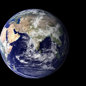
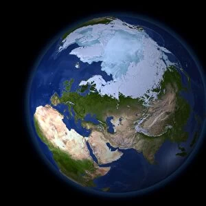
Africa, topographic map. Highlands and lowlands of the continents are shown as ridges and flat areas. Southern Europe and the Middle East are also seen at top and upper right respectively. The seabed depth varies from shallow (light blue) on the continental shelves, to deep ocean basins (dark blue). Topographic and bathymetric data is usually gathered by using aerial and satellite imagery combined with radar and sonar mapping. The satellites in this case were NOas POES satellites
Science Photo Library features Science and Medical images including photos and illustrations
Media ID 1705045
© PLANETARY VISIONS LTD/SCIENCE PHOTO LIBRARY
Africa Altimetric Altimetry Atlantic Ocean Basin Bathymetric Bathymetry Combined Data Continent Continental Shelf Continents Data Depth Depths Eurasia Floor Globe Greenland Highlands Land Lowlands Madagascar Mapped Middle East Mountains Noaa Oceanic Oceanographic Oceanography Physical Geography Plains Poes Radar Region Ridge Satellite Satellite Image Sea Bed Sea Floor Shelves Sonar Mapping Sonic Topographic Topography World
Jigsaw Puzzle (500 Pieces)
Discover the wonders of Africa with our captivating jigsaw puzzles from Media Storehouse. This intricately detailed puzzle, featuring an Africa topographic map from Science Photo Library, invites you on a journey to explore the diverse landscapes of the continent. From the towering highlands to the vast lowlands, piece together the intricate ridges and flat areas that reveal the stunning geography of Africa. As you solve the puzzle, you'll also catch a glimpse of Southern Europe and the Middle East at the top and upper right. Connect the past and present, and immerse yourself in the beauty and complexity of our world. Perfect for puzzle enthusiasts of all ages, this challenging yet rewarding puzzle is a must-have for any collection.
500 piece puzzles are custom made in the UK and hand-finished on 100% recycled 1.5 mm millboard. There is a level of repetition in jigsaw shapes with each matching piece away from its pair. The completed puzzle measures 38x50cm and is delivered packaged in an attractive presentation box specially designed to fit most letter box slots
Jigsaw Puzzles are an ideal gift for any occasion
Estimated Product Size is 38cm x 50.2cm (15" x 19.8")
These are individually made so all sizes are approximate
Artwork printed orientated as per the preview above, with landscape (horizontal) or portrait (vertical) orientation to match the source image.
FEATURES IN THESE COLLECTIONS
> Aerial Photography
> Related Images
> Africa
> Madagascar
> Maps
> Africa
> Madagascar
> Related Images
> Africa
> Related Images
> Animals
> Mammals
> Muridae
> Plains Mouse
> Arts
> Artists
> O
> Oceanic Oceanic
> Europe
> France
> Canton
> Landes
> Europe
> United Kingdom
> Scotland
> Highlands
> Related Images
> Science Photo Library
> Aerial and Satellite
EDITORS COMMENTS
This print showcases the breathtaking topography of Africa, along with glimpses of Southern Europe and the Middle East. The intricate details reveal a fascinating blend of highlands and lowlands, depicted as ridges and flat areas respectively. The varying shades of blue on the seabed illustrate the depth variations from shallow continental shelves to deep ocean basins. To create this comprehensive map, cutting-edge technology was employed. Aerial and satellite imagery combined with radar and sonar mapping techniques were utilized to gather topographic and bathymetric data. Notably, NOas POES satellites played a crucial role in capturing this remarkable view. The image not only highlights Africa's diverse landscape but also underscores its connection to neighboring regions like Southern Europe and the Middle East. It serves as a testament to our ever-expanding knowledge about Earth's physical geography. As we delve into this visual masterpiece, we are reminded of the immense beauty that lies within our planet's oceans, mountains, plains, and continents. This photograph is a stunning representation of how science merges artistry with meticulous research to provide us with invaluable insights into our world's natural wonders. Courtesy: Science Photo Library
MADE IN THE UK
Safe Shipping with 30 Day Money Back Guarantee
FREE PERSONALISATION*
We are proud to offer a range of customisation features including Personalised Captions, Color Filters and Picture Zoom Tools
SECURE PAYMENTS
We happily accept a wide range of payment options so you can pay for the things you need in the way that is most convenient for you
* Options may vary by product and licensing agreement. Zoomed Pictures can be adjusted in the Basket.

![G. N. R Peterborough Station - Details of Ironwork to New Footbridge [c1889]](/sq/229/g-n-r-peterborough-station-details-ironwork-14233715.jpg.webp)