Premium Framed Print > Europe > France > Canton > Landes
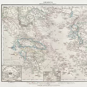
Premium Framed Print : 1865, Spruner Map of Greece, Macedonia and Thrace before the Peloponnesian War. topography


![]()
Framed Photos from Liszt Collection
1865, Spruner Map of Greece, Macedonia and Thrace before the Peloponnesian War. topography
1865, Spruner Map of Greece, Macedonia and Thrace before the Peloponnesian War
Liszt Collection of nineteenth-century engravings and images to browse and enjoy
Media ID 14006098
© Artokoloro Quint Lox Limited
Antique Map Atlas Chart Geographic Latitude Longitude Mappa Mundi Old Antique Plan Old Antique View Old Map Ols Antique Map Rare Old Maps Topo
17"x15" (43x38cm) Premium Frame
FSC real wood frame with double mounted 10x8 print. Double mounted with white conservation mountboard. Frame moulding comprises stained composite natural wood veneers (Finger Jointed Pine) 39mm wide by 21mm thick. Archival quality Fujifilm CA photo paper mounted onto 1mm card. Overall outside dimensions are 17x15 inches (431x381mm). Rear features Framing tape to cover staples, 50mm Hanger plate, cork bumpers. Glazed with durable thick 2mm Acrylic to provide a virtually unbreakable glass-like finish. Acrylic Glass is far safer, more flexible and much lighter than typical mineral glass. Moreover, its higher translucency makes it a perfect carrier for photo prints. Acrylic allows a little more light to penetrate the surface than conventional glass and absorbs UV rays so that the image and the picture quality doesn't suffer under direct sunlight even after many years. Easily cleaned with a damp cloth. Please note that, to prevent the paper falling through the mount window and to prevent cropping of the original artwork, the visible print may be slightly smaller to allow the paper to be securely attached to the mount without any white edging showing and to match the aspect ratio of the original artwork.
FSC Real Wood Frame and Double Mounted with White Conservation Mountboard - Professionally Made and Ready to Hang
Estimated Image Size (if not cropped) is 24.4cm x 19.4cm (9.6" x 7.6")
Estimated Product Size is 43.1cm x 38.1cm (17" x 15")
These are individually made so all sizes are approximate
Artwork printed orientated as per the preview above, with landscape (horizontal) orientation to match the source image.
FEATURES IN THESE COLLECTIONS
> Europe
> France
> Canton
> Landes
> Europe
> Greece
> Related Images
> Europe
> Macedonia
> Posters
> Europe
> Macedonia
> Related Images
> Historic
> Ancient civilizations
> Ancient Greece
> Greek history
> Historic
> Space exploration
> Maps and Charts
> Early Maps
EDITORS COMMENTS
This vintage print takes us back to the year 1865, showcasing a Spruner Map of Greece, Macedonia, and Thrace before the Peloponnesian War. With its intricate topography and detailed cartography, this illustration offers a unique glimpse into the geographical landscape of ancient times. The map's grid system, featuring latitude and longitude lines, guides our eyes through the geometric representation of these historical regions. Its artistic rendering captures not only the landforms but also evokes a sense of exploration and discovery that characterized this era. Printed on aged paper with an antique touch, this piece exudes a rich historical charm. It serves as a reminder of how maps were once meticulously crafted by skilled artisans to aid navigation in uncharted territories. As we observe this rare old map from The Liszt Collection, we can't help but imagine the journeys taken by explorers who relied on such cartographic treasures. It invites us to delve into history and immerse ourselves in tales of civilizations long past. Whether you are an avid collector or simply appreciate artful depictions of our world's heritage, this decorative print is sure to captivate your imagination. Let it transport you back in time as you explore the fascinating region encompassing Greece, Macedonia, and Thrace before one of antiquity's most significant conflicts - The Peloponnesian War.
MADE IN THE UK
Safe Shipping with 30 Day Money Back Guarantee
FREE PERSONALISATION*
We are proud to offer a range of customisation features including Personalised Captions, Color Filters and Picture Zoom Tools
SECURE PAYMENTS
We happily accept a wide range of payment options so you can pay for the things you need in the way that is most convenient for you
* Options may vary by product and licensing agreement. Zoomed Pictures can be adjusted in the Basket.