Photographic Print > Europe > France > Canton > Landes
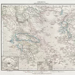
Photographic Print : 1865, Spruner Map of Greece, Macedonia and Thrace before the Peloponnesian War. topography


![]()
Photo Prints from Liszt Collection
1865, Spruner Map of Greece, Macedonia and Thrace before the Peloponnesian War. topography
1865, Spruner Map of Greece, Macedonia and Thrace before the Peloponnesian War
Liszt Collection of nineteenth-century engravings and images to browse and enjoy
Media ID 14006098
© Artokoloro Quint Lox Limited
Antique Map Atlas Chart Geographic Latitude Longitude Mappa Mundi Old Antique Plan Old Antique View Old Map Ols Antique Map Rare Old Maps Topo
10"x8" (25x20cm) Photo Print
Discover history like never before with our exquisite selection of vintage maps from the Media Storehouse Photographic Prints collection. This stunning print features the 1865 Spruner Map of Greece, Macedonia, and Thrace, expertly sourced from the esteemed Liszt Collection. Witness the intricate topography of the region as it appeared before the Peloponnesian War. Each detail is meticulously captured in high-resolution, allowing you to explore the rich history and geography of ancient Greece in breathtaking detail. Bring the past into your present with this captivating, museum-quality print. Perfect for history enthusiasts, educators, or anyone seeking an elegant addition to their home or office décor. Experience the allure of history with this unique and captivating piece from Media Storehouse.
Printed on archival quality paper for unrivalled stable artwork permanence and brilliant colour reproduction with accurate colour rendition and smooth tones. Printed on professional 234gsm Fujifilm Crystal Archive DP II paper. 10x8 for landscape images, 8x10 for portrait images.
Our Photo Prints are in a large range of sizes and are printed on Archival Quality Paper for excellent colour reproduction and longevity. They are ideal for framing (our Framed Prints use these) at a reasonable cost. Alternatives include cheaper Poster Prints and higher quality Fine Art Paper, the choice of which is largely dependant on your budget.
Estimated Product Size is 25.4cm x 20.3cm (10" x 8")
These are individually made so all sizes are approximate
Artwork printed orientated as per the preview above, with landscape (horizontal) or portrait (vertical) orientation to match the source image.
FEATURES IN THESE COLLECTIONS
> Europe
> France
> Canton
> Landes
> Europe
> Greece
> Related Images
> Europe
> Macedonia
> Posters
> Europe
> Macedonia
> Related Images
> Historic
> Ancient civilizations
> Ancient Greece
> Greek history
> Historic
> Space exploration
> Maps and Charts
> Early Maps
EDITORS COMMENTS
This vintage print takes us back to the year 1865, showcasing a Spruner Map of Greece, Macedonia, and Thrace before the Peloponnesian War. With its intricate topography and detailed cartography, this illustration offers a unique glimpse into the geographical landscape of ancient times. The map's grid system, featuring latitude and longitude lines, guides our eyes through the geometric representation of these historical regions. Its artistic rendering captures not only the landforms but also evokes a sense of exploration and discovery that characterized this era. Printed on aged paper with an antique touch, this piece exudes a rich historical charm. It serves as a reminder of how maps were once meticulously crafted by skilled artisans to aid navigation in uncharted territories. As we observe this rare old map from The Liszt Collection, we can't help but imagine the journeys taken by explorers who relied on such cartographic treasures. It invites us to delve into history and immerse ourselves in tales of civilizations long past. Whether you are an avid collector or simply appreciate artful depictions of our world's heritage, this decorative print is sure to captivate your imagination. Let it transport you back in time as you explore the fascinating region encompassing Greece, Macedonia, and Thrace before one of antiquity's most significant conflicts - The Peloponnesian War.
MADE IN THE UK
Safe Shipping with 30 Day Money Back Guarantee
FREE PERSONALISATION*
We are proud to offer a range of customisation features including Personalised Captions, Color Filters and Picture Zoom Tools
SECURE PAYMENTS
We happily accept a wide range of payment options so you can pay for the things you need in the way that is most convenient for you
* Options may vary by product and licensing agreement. Zoomed Pictures can be adjusted in the Basket.