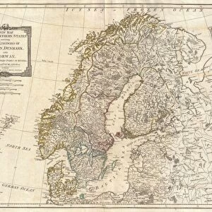
Premium Framed Print : 1730, Homann Map of Scandinavia, Norway, Sweden, Denmark, Finland and the Baltics


![]()
Framed Photos from Liszt Collection
1730, Homann Map of Scandinavia, Norway, Sweden, Denmark, Finland and the Baltics
Liszt Collection of nineteenth-century engravings and images to browse and enjoy
Media ID 14004514
© Artokoloro Quint Lox Limited
1730 Denmark Norway Sweden Antique Map Atlas Chart Geographic Latitude Longitude Mappa Mundi Old Antique Plan Old Antique View Old Map Ols Antique Map Rare Old Maps Topo
17"x15" (43x38cm) Premium Frame
FSC real wood frame with double mounted 10x8 print. Double mounted with white conservation mountboard. Frame moulding comprises stained composite natural wood veneers (Finger Jointed Pine) 39mm wide by 21mm thick. Archival quality Fujifilm CA photo paper mounted onto 1mm card. Overall outside dimensions are 17x15 inches (431x381mm). Rear features Framing tape to cover staples, 50mm Hanger plate, cork bumpers. Glazed with durable thick 2mm Acrylic to provide a virtually unbreakable glass-like finish. Acrylic Glass is far safer, more flexible and much lighter than typical mineral glass. Moreover, its higher translucency makes it a perfect carrier for photo prints. Acrylic allows a little more light to penetrate the surface than conventional glass and absorbs UV rays so that the image and the picture quality doesn't suffer under direct sunlight even after many years. Easily cleaned with a damp cloth. Please note that, to prevent the paper falling through the mount window and to prevent cropping of the original artwork, the visible print may be slightly smaller to allow the paper to be securely attached to the mount without any white edging showing and to match the aspect ratio of the original artwork.
FSC Real Wood Frame and Double Mounted with White Conservation Mountboard - Professionally Made and Ready to Hang
Estimated Image Size (if not cropped) is 24.4cm x 20.9cm (9.6" x 8.2")
Estimated Product Size is 43.1cm x 38.1cm (17" x 15")
These are individually made so all sizes are approximate
Artwork printed orientated as per the preview above, with landscape (horizontal) orientation to match the source image.
EDITORS COMMENTS
This print showcases the remarkable "1730, Homann Map of Scandinavia, Norway, Sweden, Denmark, Finland and the Baltics". A true masterpiece of cartography and geography, this vintage map takes us on a journey through time to explore the ancient lands of Northern Europe. The intricate details and topographical accuracy depicted in this illustration are truly awe-inspiring. From the majestic fjords of Norway to the sprawling forests of Sweden and Finland, every geographic feature is meticulously captured. The grid lines marking latitude and longitude add a touch of geometric precision to this artistic representation. With its aged appearance and historical charm, this old map transports us back to an era when navigation relied on such beautifully crafted pieces. It serves as a window into our past, reminding us of the importance placed on exploration and discovery during those times. As we gaze upon this rare antique map from the Liszt Collection, we can't help but appreciate its decorative value as well. Its earthy tones blend harmoniously with any interior decor style while adding a touch of sophistication. Whether you're an avid history enthusiast or simply appreciate artful representations of our world's regions throughout time, this Homann Map print is sure to captivate your imagination. Let it transport you to bygone eras where maps were not just tools for navigation but works of art that celebrated our planet's diverse landscapes.
MADE IN THE UK
Safe Shipping with 30 Day Money Back Guarantee
FREE PERSONALISATION*
We are proud to offer a range of customisation features including Personalised Captions, Color Filters and Picture Zoom Tools
SECURE PAYMENTS
We happily accept a wide range of payment options so you can pay for the things you need in the way that is most convenient for you
* Options may vary by product and licensing agreement. Zoomed Pictures can be adjusted in the Basket.