Poster Print > Europe > France > Canton > Landes
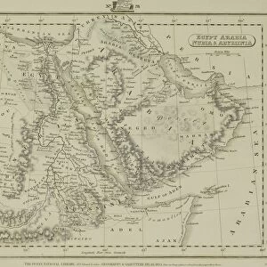
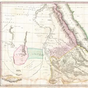
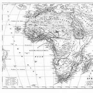
Poster Print : 1771, Bonne Map of Abyssinia, Ethiopia, Sudan and the Red Sea, Rigobert Bonne 1727 - 1794


![]()
Poster Prints from Liszt Collection
1771, Bonne Map of Abyssinia, Ethiopia, Sudan and the Red Sea, Rigobert Bonne 1727 - 1794
1771, Bonne Map of Abyssinia, Ethiopia, Sudan and the Red Sea, Rigobert Bonne 1727 - 1794, one of the most important cartographers of the late 18th century
Liszt Collection of nineteenth-century engravings and images to browse and enjoy
Media ID 14004681
© Artokoloro Quint Lox Limited
1771 Ethiopia Rigobert Bonne 1727 1794 Rigobert Bonne 1727 – 1794 Rigobert Bonne 17271794 Antique Map Atlas Chart Geographic Latitude Longitude Mappa Mundi Old Antique Plan Old Antique View Old Map Ols Antique Map Rare Old Maps Topo
A2 (59.4 x 42cm) Poster Print
Discover the rich history and geography of Abyssinia, Ethiopia, Sudan, and the Red Sea with our stunning poster print from the Media Storehouse collection. This exquisite reproduction showcases the intricate detail of Rigobert Bonne's 1771 map, a masterpiece from the renowned cartographer's late 18th-century oeuvre. The Liszt Collection Bonne Map transports you back in time, offering a captivating glimpse into the cartographic knowledge of the era. Adorn your walls with this beautiful and educational piece, a must-have for history enthusiasts, geography aficionados, and collectors alike.
A2 Poster (59.4 x 42cm, 23.4" x 16.5" inches) printed on 170gsm Satin Poster Paper. Securely packaged, rolled and inserted into a strong mailing tube and shipped tracked. Poster Prints are of comparable archival quality to our Photographic prints, they are simply printed on thinner Poster Paper. Whilst we only use Photographic Prints in our frames, you can frame Poster Prints if they are carefully supported to prevent sagging over time.
Poster prints are budget friendly enlarged prints in standard poster paper sizes (A0, A1, A2, A3 etc). Whilst poster paper is sometimes thinner and less durable than our other paper types, they are still ok for framing and should last many years. Our Archival Quality Photo Prints and Fine Art Paper Prints are printed on higher quality paper and the choice of which largely depends on your budget.
Estimated Product Size is 59.4cm x 42cm (23.4" x 16.5")
These are individually made so all sizes are approximate
Artwork printed orientated as per the preview above, with landscape (horizontal) orientation to match the source image.
EDITORS COMMENTS
This vintage print showcases the remarkable 1771 Bonne Map of Abyssinia, Ethiopia, Sudan, and the Red Sea. Created by Rigobert Bonne (1727-1794), one of the most influential cartographers of the late 18th century, this map offers a fascinating glimpse into the topography and geography of these regions. With intricate details and precise measurements, Bonne's map captures the essence of these lands with accuracy and artistry. It presents a comprehensive view of various landmarks such as mountains, rivers, coastlines, and cities. The grid lines depicting latitude and longitude further enhance its navigational value. As an ancient piece steeped in history, this decorative illustration transports us back to a time when exploration was at its peak. Its aged appearance adds an air of authenticity that appeals to both historians and art enthusiasts alike. The meticulous craftsmanship evident in this old antique plan is a testament to Bonne's expertise as a cartographer. His dedication to accurately representing geographical features has made his maps highly sought after by collectors worldwide. Whether you are fascinated by historical maps or simply appreciate fine artistry, this rare print from Liszt Collection allows you to own a piece of geographic history. Let it transport you on a journey through time as you explore the rich landscapes depicted within its borders.
MADE IN THE UK
Safe Shipping with 30 Day Money Back Guarantee
FREE PERSONALISATION*
We are proud to offer a range of customisation features including Personalised Captions, Color Filters and Picture Zoom Tools
SECURE PAYMENTS
We happily accept a wide range of payment options so you can pay for the things you need in the way that is most convenient for you
* Options may vary by product and licensing agreement. Zoomed Pictures can be adjusted in the Basket.