Jigsaw Puzzle > Fine Art Finder > Artists > John Speed
Jigsaw Puzzle : A map of New England and New York from John Speeds Theatre of the Empire of Great Britain


Please select a smaller print size for this image
![]()
Jigsaw Puzzles from Fine Art Finder
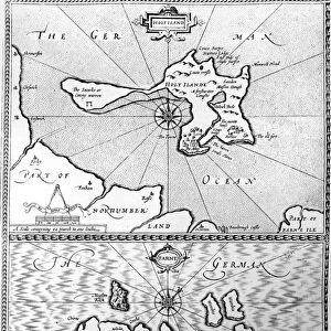
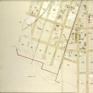
A map of New England and New York from John Speeds Theatre of the Empire of Great Britain
XOS1765718 A map of New England and New York from John Speeds Theatre of the Empire of Great Britain, 1676 (colour print) by Speed, John (1552-1629); 38x48 cm; New York Public Library, USA; (add.info.:
); English, out of copyright
Media ID 12742623
© www.bridgemanimages.com
American Indian Atlas British Colony British Empire Colonial America Hydrography Latitude Longitude Navigation New England New Jersey North Sea Rhumb Lines Sea Chart
Jigsaw Puzzle (500 Pieces)
Discover the historical charm of the past with Media Storehouse's Jigsaw Puzzle featuring a captivating map of New England and New York from John Speeds Theatre of the Empire of Great Britain. This intricately detailed puzzle, showcasing a color print from 1676, invites you on a journey back in time. Immerse yourself in the rich history of the region as you piece together this beautiful work of art by renowned English cartographer, John Speed. A perfect activity for history enthusiasts, puzzle lovers, or anyone seeking a fun and engaging way to unwind.
500 piece puzzles are custom made in the UK and hand-finished on 100% recycled 1.5 mm millboard. There is a level of repetition in jigsaw shapes with each matching piece away from its pair. The completed puzzle measures 38x50cm and is delivered packaged in an attractive presentation box specially designed to fit most letter box slots
Jigsaw Puzzles are an ideal gift for any occasion
Estimated Product Size is 50.2cm x 38cm (19.8" x 15")
These are individually made so all sizes are approximate
Artwork printed orientated as per the preview above, with landscape (horizontal) or portrait (vertical) orientation to match the source image.
EDITORS COMMENTS
This vibrant and detailed print showcases a map of New England and New York from John Speed's renowned Theatre of the Empire of Great Britain. Created in 1676, this color print measures 38x48 cm and is housed in the prestigious New York Public Library, USA. The map captures the essence of cartography as it beautifully depicts the intricate coastlines, hydrography, sea charts, longitude, latitude, and even rhumb lines. It offers a fascinating glimpse into colonial America during its early stages as a British colony. As you explore this historical piece, you'll notice various elements that add to its allure. The presence of native American tribes is represented through their settlements scattered across the land. Additionally, animals indigenous to North America are illustrated with great attention to detail. The inclusion of coat-of-arms further emphasizes the connection between Britain and its colonies across the Atlantic Ocean. This maritime-themed artwork not only serves as an essential navigation tool but also highlights significant discoveries made during exploration expeditions. With pictorial relief techniques employed throughout the map's design, viewers can almost feel themselves traversing these uncharted territories alongside early explorers. As an invaluable part of British history within America's context, this print provides us with a captivating visual representation of our past.
MADE IN THE UK
Safe Shipping with 30 Day Money Back Guarantee
FREE PERSONALISATION*
We are proud to offer a range of customisation features including Personalised Captions, Color Filters and Picture Zoom Tools
SECURE PAYMENTS
We happily accept a wide range of payment options so you can pay for the things you need in the way that is most convenient for you
* Options may vary by product and licensing agreement. Zoomed Pictures can be adjusted in the Basket.