Home > Arts > Artists > B > Joan Blaeu
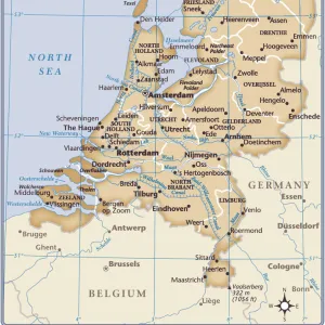
Map of California shown as an island, c 1650. Creator: Johannes Vingboons

![]()
Wall Art and Photo Gifts from Heritage Images
Map of California shown as an island, c 1650. Creator: Johannes Vingboons
Map of California shown as an island, c 1650. This map from around 1650 shows California as an island. A half-century would pass before Spanish explorers determined with certainty that California was connected to the mainland of North America. Place names are carefully indicated on the map in red and black, and include, for example, Cape San Lucas (at the tip of present-day Baja California), Mexico, and the Tres Maria Islands off the coast of the Mexican mainland. Joan Vinckeboons (1617-70) was a Dutch cartographer and engraver born into a family of artists of Flemish origin. He was in the employ of the Dutch West India Company and produced maps for over 30 years for use by Dutch mercantile and military shipping. He was a business partner of Joan Blaeu, one of the most important map and atlas publishers of the day. Vinckeboons drew a series of 200 manuscript maps that were used in the production of atlases, including Blaeu's Atlas Major
Heritage Images features heritage image collections
Media ID 35130377
© Heritage Art/Heritage Images
1650s Atlas California United States Of America Cartographer Cartographic Cartography Discovering Discovery Dutch West India Company Exploration Exploring Joan Blaeu Johann Blaeu Johannes Blaeu Map Making Mapmaker Mapmaking North America Compass Rose Low Countries Meeting Of Frontiers Netherlands Europe
FEATURES IN THESE COLLECTIONS
> Animals
> Mammals
> Cricetidae
> California Mouse
> Arts
> Artists
> B
> Joan Blaeu
> Europe
> Netherlands
> Maps
> Europe
> Netherlands
> Posters
> Europe
> Netherlands
> Related Images
> Historic
> Colonial America illustrations
> Colonial America
> Historic
> Colonial history
> Colonial art and artists
EDITORS COMMENTS
This intriguing map, created by Dutch cartographer and engraver Johannes Vingboons around 1650, depicts California as an island. At a time when European explorers were still piecing together the vast geography of the New World, this representation of California as an insular entity was not uncommon. However, it would take another half-century before Spanish explorers, such as Gaspar de Portolà and Juan Crespí, would definitively establish the peninsular connection between California and the North American mainland. Vingboons meticulously marked place names on the map in red and black, including notable features such as Cape San Lucas (present-day Baja California), Mexico, and the Tres Maria Islands off the coast of the Mexican mainland. Born into a family of artists of Flemish origin, Vingboons began his career in the employ of the Dutch East India Company. He later became a business partner of Joan Blaeu, one of the most influential map and atlas publishers of the day. Vingboons is known for his extensive body of work, which includes over 200 manuscript maps that were used in the production of various atlases. This map, with its detailed cartography and vibrant color palette, is a testament to Vingboons' skill and the era's fascination with the exploration and mapping of the New World.
MADE IN THE UK
Safe Shipping with 30 Day Money Back Guarantee
FREE PERSONALISATION*
We are proud to offer a range of customisation features including Personalised Captions, Color Filters and Picture Zoom Tools
SECURE PAYMENTS
We happily accept a wide range of payment options so you can pay for the things you need in the way that is most convenient for you
* Options may vary by product and licensing agreement. Zoomed Pictures can be adjusted in the Basket.