Framed Print > Animals > Mammals > Muridae > Water Mouse
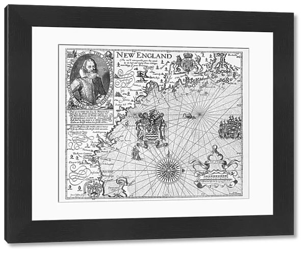
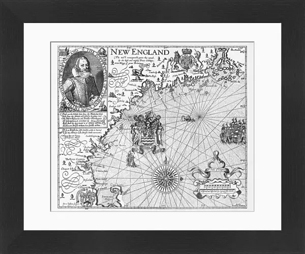
Framed Print : Map of New England by Explorer John Smith, Circa 1624


![]()
Framed Photos from Fine Art Storehouse
Map of New England by Explorer John Smith, Circa 1624
Beautifully Illustrated Antique Engraved Victorian Illustration of Historical Map of New England from Explorer Captain John Smith, Circa 1624. Source: Original edition from my own archives. Copyright has expired on this artwork. Digitally restored
Unleash your creativity and transform your space into a visual masterpiece!
bauhaus1000
Media ID 13667109
© bauhaus1000
17th Century 17th Century Style 78271 Admiral American Culture Bay Of Water Boat Captain Chart Crossing Direction Discovery Explorer Fine Art Portrait Graph Image Created 17th Century Journey Knight Person Maine Massachusetts Navigational Equipment New England Usa Passenger Ship Period Costume Pilgrim Sailing Sailing Ship Sailor Ship The Americas Virginia Virginia Us State Chesapeake Bay Nautical Equipment Puritanism
14"x12" (38x32cm) Modern Frame
Step back in time with our exquisite Framed Print of the "Map of New England" by renowned explorer Captain John Smith. Dating back to 1624, this beautifully illustrated antique engraving transports you to the Victorian era. Meticulously sourced from the original edition, this historical map showcases intricate details and is a must-have for history enthusiasts, cartography collectors, or anyone seeking to add a touch of timeless charm to their decor. Bring the rich history of New England into your home or office with this stunning piece from Media Storehouse's Fine Art collection.
Wood effect frame, card mounted, 10x8 archival quality photo print. Overall outside dimensions 14x12 inches (38x32cm). Environmentally and ozone friendly, 40mm wide x 15mm Polycore® moulding has the look of real wood, is durable and light and easy to hang. Biodegradable and made with non-chlorinated gases (no toxic fumes) it is efficient; producing 100 tons of polystyrene can save 300 tons of trees! Prints are glazed with lightweight, shatterproof, optical clarity acrylic (providing the same general protection from the environment as glass). The back is stapled hardboard with a sawtooth hanger attached. Note: To minimise original artwork cropping, for optimum layout, and to ensure print is secure, the visible print may be marginally smaller
Contemporary Framed and Mounted Prints - Professionally Made and Ready to Hang
Estimated Image Size (if not cropped) is 24.4cm x 20.2cm (9.6" x 8")
Estimated Product Size is 37.6cm x 32.5cm (14.8" x 12.8")
These are individually made so all sizes are approximate
Artwork printed orientated as per the preview above, with landscape (horizontal) orientation to match the source image.
FEATURES IN THESE COLLECTIONS
> Fine Art Storehouse
> Map
> Historical Maps
> Fine Art Storehouse
> Map
> USA Maps
> Animals
> Mammals
> Muridae
> Water Mouse
> Arts
> Artists
> W
> John White
> Arts
> Contemporary art
> Digital artwork
> Portraits
> Arts
> Contemporary art
> Portraits
> Digital art
> Arts
> Portraits
> Black and white portraits
> Fine art portraits
> Arts
> Portraits
> Black and white portraits
> Arts
> Street art graffiti
> Digital art
> Digital paintings
> Arts
> Street art graffiti
> Portraits
> Fine art
> Europe
> France
> Canton
> Maine
EDITORS COMMENTS
This beautifully illustrated antique engraving showcases a historical map of New England, meticulously crafted by the renowned explorer Captain John Smith circa 1624. The print, sourced from the original edition in my personal archives, has been digitally restored to its former glory. The image transports us back to the 17th century, immersing us in a world of cartography and nautical exploration. A majestic sailing ship dominates the scene, symbolizing the spirit of adventure and discovery that characterized this era. In this portrait-like depiction, Captain John Smith himself stands proudly at the helm as an admiral and explorer. Every detail is captured with precision – from the intricate engravings on nautical equipment to period costumes worn by sailors and knights aboard. The map encompasses not only Massachusetts and Maine but also Virginia's Jamestown settlement, Chesapeake Bay, and other significant landmarks along America's eastern coast. As we gaze upon this black-and-white masterpiece, it evokes a sense of awe for our rich history and cultural heritage. It serves as a reminder of how far we have come since those early days of exploration while honoring those who paved the way for future generations. This artwork invites us to embark on a journey through time - where curiosity meets courage - inspiring both travel enthusiasts and history buffs alike with its timeless charm.
MADE IN THE UK
Safe Shipping with 30 Day Money Back Guarantee
FREE PERSONALISATION*
We are proud to offer a range of customisation features including Personalised Captions, Color Filters and Picture Zoom Tools
SECURE PAYMENTS
We happily accept a wide range of payment options so you can pay for the things you need in the way that is most convenient for you
* Options may vary by product and licensing agreement. Zoomed Pictures can be adjusted in the Basket.