Framed Print > Maps and Charts > Early Maps
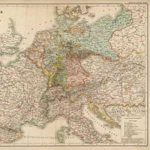
Framed Print : Map of Europe after the Peace of Luneville, 1801, from A Short History of the


![]()
Framed Photos From Fine Art Finder
Map of Europe after the Peace of Luneville, 1801, from A Short History of the
KW392528 Map of Europe after the Peace of Luneville, 1801, from A Short History of the English People by J. R. Green, published 1893 (colour litho) by English School, (19th century); Private Collection; Ken Welsh; English, out of copyright
Media ID 12871980
© www.bridgemanimages.com
Borders Countries Diagram Empires Frontiers Region Regions Territories Territory Treaty
14"x12" (38x32cm) Modern Frame
Add a touch of historical elegance to your home or office with our Framed Prints from Media Storehouse, featuring the Map of Europe after the Peace of Luneville in 1801. This captivating map, taken from J.R. Green's "A Short History of the English People," showcases the political landscape of Europe following the treaty that ended the War of the First Coalition. The vibrant colors and intricate details bring the history to life, making this a perfect addition to any room. Order your Framed Print today and step back in time!
Wood effect frame, card mounted, 10x8 archival quality photo print. Overall outside dimensions 14x12 inches (38x32cm). Environmentally and ozone friendly, 40mm wide x 15mm Polycore® moulding has the look of real wood, is durable and light and easy to hang. Biodegradable and made with non-chlorinated gases (no toxic fumes) it is efficient; producing 100 tons of polystyrene can save 300 tons of trees! Prints are glazed with lightweight, shatterproof, optical clarity acrylic (providing the same general protection from the environment as glass). The back is stapled hardboard with a sawtooth hanger attached. Note: To minimise original artwork cropping, for optimum layout, and to ensure print is secure, the visible print may be marginally smaller
Contemporary Framed and Mounted Prints - Professionally Made and Ready to Hang
Estimated Image Size (if not cropped) is 24.4cm x 16.9cm (9.6" x 6.7")
Estimated Product Size is 37.6cm x 32.5cm (14.8" x 12.8")
These are individually made so all sizes are approximate
Artwork printed orientated as per the preview above, with landscape (horizontal) orientation to match the source image.
FEATURES IN THESE COLLECTIONS
> Fine Art Finder
> Maps (celestial & Terrestrial)
> Fine Art Finder
> Schools
> English School
> Maps and Charts
> Early Maps
> Maps and Charts
> Related Images
EDITORS COMMENTS
This print showcases the "Map of Europe after the Peace of Luneville, 1801" a significant historical artifact from J. R. Green's renowned book, A Short History of the English People. Published in 1893, this color lithograph offers a fascinating glimpse into the political landscape of Europe during that time. The map vividly depicts the various countries, regions, and territories that emerged following the signing of the Peace of Luneville treaty. It serves as a visual representation of how borders and frontiers were redrawn after this pivotal moment in European history. The intricate details on this illustration provide valuable insights into different empires' extents and their influence over specific areas. As we delve into this image, we are transported back to an era where diplomacy played a crucial role in shaping nations' destinies. The Map of Europe after the Peace of Luneville not only highlights territorial changes but also symbolizes hope for lasting peace among these powerful entities. Preserved within a private collection and made available by Ken Welsh through Fine Art Finder at www. bridgemanimages. com, this photograph print allows us to appreciate both its artistic beauty and historical significance. It serves as a reminder that even centuries later, maps continue to be invaluable tools for understanding our world's complex pasts while offering glimpses into future possibilities.
MADE IN THE UK
Safe Shipping with 30 Day Money Back Guarantee
FREE PERSONALISATION*
We are proud to offer a range of customisation features including Personalised Captions, Color Filters and Picture Zoom Tools
SECURE PAYMENTS
We happily accept a wide range of payment options so you can pay for the things you need in the way that is most convenient for you
* Options may vary by product and licensing agreement. Zoomed Pictures can be adjusted in the Basket.