Fine Art Print > Animals > Mammals > Muridae > Desert Mouse
Fine Art Print : Richat Structure, satellite image


![]()
Fine Art Prints from Science Photo Library
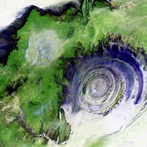
Richat Structure, satellite image
Richat Structure, satellite image. North is at top. Desert sands are pale yellow/white (top left and lower right), while less sandy, rocky areas are green, and volcanic rocks are blue. The Richat Structure is an eroded volcanic dome in the deserts of Mauritania. As the volcanic dome eroded, these onion-like layers of rock were exposed. The structure is 485 metres high, and nearly 50 kilometres across. It is in the Maur Adrar Desert, in the Western Sahara. The area shown in this image is around 66 kilometres wide. The image data includes infrared wavelengths, and was obtained on 11 January 2001, by the Landsat 7 satellite
Science Photo Library features Science and Medical images including photos and illustrations
Media ID 6360535
© NASA/SCIENCE PHOTO LIBRARY
2000s 2001 Africa African Arid Desert Earth Observation Earth Science Eroded From Space Geological Infra Red January Land Landsat 7 Mauritania Mauritanian Physical Geography Rocky Sahara Saharan Sandy Satellite Satellite Image Volcanic Weathered
A2 (42x59cm) Fine Art Print
Discover the enigmatic beauty of the Richat Structure with our Fine Art Prints from Media Storehouse. This satellite image, captured by Science Photo Library, reveals the intriguing desert formation's unique pattern of pale yellow and white desert sands contrasting against less sandy, green areas and volcanic rocks in shades of blue. Bring this mesmerizing geological wonder into your home or office as a captivating conversation starter and a testament to the wonders of our natural world.
Our Fine Art Prints are printed on 100% acid free, PH neutral paper with archival properties. This printing method is used by museums and art collections to exhibit photographs and art reproductions. Hahnemühle certified studio for digital fine art printing. Printed on 308gsm Photo Rag Paper.
Our fine art prints are high-quality prints made using a paper called Photo Rag. This 100% cotton rag fibre paper is known for its exceptional image sharpness, rich colors, and high level of detail, making it a popular choice for professional photographers and artists. Photo rag paper is our clear recommendation for a fine art paper print. If you can afford to spend more on a higher quality paper, then Photo Rag is our clear recommendation for a fine art paper print.
Estimated Image Size (if not cropped) is 42cm x 42.1cm (16.5" x 16.6")
Estimated Product Size is 42cm x 59.4cm (16.5" x 23.4")
These are individually made so all sizes are approximate
Artwork printed orientated as per the preview above, with portrait (vertical) orientation to match the source image.
FEATURES IN THESE COLLECTIONS
> Africa
> Mauritania
> Related Images
> Africa
> Related Images
> Africa
> Western Sahara
> Related Images
> Animals
> Mammals
> Muridae
> Desert Mouse
> Animals
> Mammals
> Muridae
> Western Mouse
> Europe
> France
> Canton
> Landes
> Science
> Space Exploration
> Related Images
> Science
> Space Exploration
> Satellite Imagery
> Science Photo Library
> Aerial and Satellite
EDITORS COMMENTS
This print showcases the mesmerizing Richat Structure, a remarkable geological wonder located in the deserts of Mauritania. The satellite image reveals an aerial perspective with north at the top, allowing us to appreciate the vastness and intricate details of this natural formation. The contrasting colors paint a vivid picture: pale yellow/white desert sands dominate the top left and lower right corners, while lush green areas indicate less sandy rocky terrain. The striking blue hues represent volcanic rocks that add another layer of complexity to this eroded volcanic dome. Standing tall at 485 meters high and spanning nearly 50 kilometers across, the Richat Structure is truly awe-inspiring. As erosion took its course over time, it unveiled these fascinating onion-like layers of rock that now captivate our imagination. This particular image was captured on January 11th, 2001 by Landsat 7 satellite using infrared wavelengths. Situated within the Maur Adrar Desert in Western Sahara, this photograph showcases an area approximately 66 kilometers wide. It offers a glimpse into Africa's arid beauty and highlights how nature's forces shape our planet's landscapes. With its rich geological history and unique features, including dome mountains formed through volcanic activity, this image serves as a testament to Earth's diverse physical geography. Courtesy of Science Photo Library (not affiliated with any company), this stunning print invites us to marvel at our planet's wonders from space while appreciating the artistry created by millions of years' worth of weathering and erosion processes.
MADE IN THE UK
Safe Shipping with 30 Day Money Back Guarantee
FREE PERSONALISATION*
We are proud to offer a range of customisation features including Personalised Captions, Color Filters and Picture Zoom Tools
SECURE PAYMENTS
We happily accept a wide range of payment options so you can pay for the things you need in the way that is most convenient for you
* Options may vary by product and licensing agreement. Zoomed Pictures can be adjusted in the Basket.