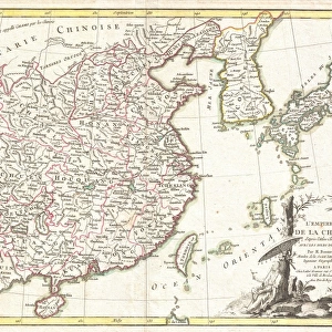
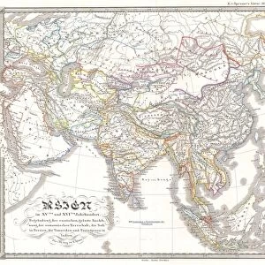
Antique Framed Print : 1771, Bonne Map of Tonkin, Vietnam China, Formosa, Taiwan and Luzon, Philippines


![]()
Framed Photos from Liszt Collection
1771, Bonne Map of Tonkin, Vietnam China, Formosa, Taiwan and Luzon, Philippines
1771, Bonne Map of Tonkin, Vietnam China, Formosa, Taiwan and Luzon, Philippines, Rigobert Bonne 1727 - 1794, one of the most important cartographers of the late 18th century
Liszt Collection of nineteenth-century engravings and images to browse and enjoy
Media ID 14004710
© Artokoloro Quint Lox Limited
1771 Formosa Philippines Rigobert Bonne 1727 1794 Rigobert Bonne 1727 – 1794 Rigobert Bonne 17271794 Antique Map Atlas Chart Geographic Latitude Longitude Mappa Mundi Old Antique Plan Old Antique View Old Map Ols Antique Map Rare Old Maps Topo
14"x12" (36x31cm) Antique Frame
Bevelled wood effect frame, card mounted, 10x8 archival quality photo print. Overall outside dimensions 14x12 inches (36x31cm). Environmentally and ozone friendly, the Polycore® moulding has the look of real wood, is durable and light and easy to hang. Biodegradable and made with non-chlorinated gases (no toxic fumes) it is efficient; producing 100 tons of polystyrene can save 300 tons of trees! Prints are glazed with lightweight, shatterproof, optical clarity acrylic (providing the same general protection from the environment as glass). The back is stapled hardboard with a sawtooth hanger attached. Note: To minimise original artwork cropping, for optimum layout, and to ensure print is secure, the visible print may be marginally smaller
Bevelled Wood Effect Framed and Mounted Prints - Professionally Made and Ready to Hang
Estimated Image Size (if not cropped) is 24.4cm x 17.8cm (9.6" x 7")
Estimated Product Size is 36.3cm x 31.2cm (14.3" x 12.3")
These are individually made so all sizes are approximate
Artwork printed orientated as per the preview above, with landscape (horizontal) orientation to match the source image.
EDITORS COMMENTS
This vintage print showcases the exquisite 1771 Bonne Map of Tonkin, Vietnam China, Formosa (Taiwan), and Luzon, Philippines. Created by the renowned cartographer Rigobert Bonne in the late 18th century, this map is a testament to his mastery of topography and geography. The intricate details on this map provide a fascinating glimpse into the past. It captures the geographical features of these regions with precision, including mountains, rivers, and coastlines. The carefully plotted grid lines denote latitude and longitude coordinates, making it an invaluable tool for navigation during that era. As an ancient artifact steeped in history, this print evokes a sense of nostalgia. Its aged appearance adds to its charm as it transports us back to a time when exploration and discovery were at their peak. This rare piece serves as a window into how our ancestors perceived the world around them. With its decorative elements and artistic flair, this map is not only informative but also visually captivating. Its detailed illustrations bring life to each region depicted on it – from bustling cities to vast expanses of uncharted land. Whether you are an avid collector or simply appreciate historical artifacts like maps, this Bonne Map print is sure to be a treasured addition to your collection. Let it take you on a journey through time as you explore the rich tapestry of Southeast Asia's past through cartographic artistry.
MADE IN THE UK
Safe Shipping with 30 Day Money Back Guarantee
FREE PERSONALISATION*
We are proud to offer a range of customisation features including Personalised Captions, Color Filters and Picture Zoom Tools
SECURE PAYMENTS
We happily accept a wide range of payment options so you can pay for the things you need in the way that is most convenient for you
* Options may vary by product and licensing agreement. Zoomed Pictures can be adjusted in the Basket.