Home > Arts > Artists > R > Pedro Reinel
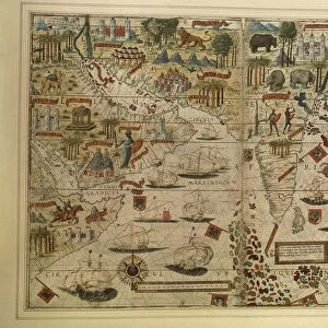
Map of India and Indian Ocean, from Miller Atlas by Pedro and Jorge Reinel, Lopo Homen, cartographers and Antonio de Holanda, miniaturist, 1519

![]()
Wall Art and Photo Gifts from Universal Images Group (UIG)
Map of India and Indian Ocean, from Miller Atlas by Pedro and Jorge Reinel, Lopo Homen, cartographers and Antonio de Holanda, miniaturist, 1519
Cartography, 16th century. Map of India and Indian Ocean, from Miller Atlas, by Pedro and Jorge Reinel, Lopo Homen (cartographers) and Antonio de Holanda (miniaturist), 1519
Universal Images Group (UIG) manages distribution for many leading specialist agencies worldwide
Media ID 9505413
© DEA / J. E. BULLOZ
16th Century Barge Coastline Compass Rose Direction Exploration Guidance India Indian Ocean Nautical Vessel Sailing Ship Sign Symbol
FEATURES IN THESE COLLECTIONS
> Arts
> Artists
> R
> Jorge Reinel
> Arts
> Artists
> R
> Pedro Reinel
> Universal Images Group (UIG)
> Art
> Painting, Sculpture & Prints
> Cartography
EDITORS COMMENTS
This print showcases a remarkable piece of cartographic history - the Map of India and Indian Ocean from the Miller Atlas, created by Pedro and Jorge Reinel, Lopo Homen (cartographers), and Antonio de Holanda (miniaturist) in 1519. The image transports us back to the 16th century, where exploration and colonialism were at their peak. The map itself is a testament to human curiosity and the thirst for knowledge during this era. It provides valuable guidance for sailors navigating through uncharted waters, with its intricate compass rose indicating cardinal directions. The detailed coastline outlines offer insight into the geographical features of India and its surrounding regions. In this particular scene, we see a signpost erected on an idyllic shoreline overlooking the vast Indian Ocean. A majestic sailing ship gracefully glides across the water's surface while exotic animal motifs adorn both land and sea. People gather around, perhaps seeking direction or marveling at this extraordinary work of art that encapsulates their world. As we gaze upon this historical masterpiece captured in vibrant colors against a clear blue sky, we are reminded of our connection to those who came before us - explorers who braved unknown territories in search of new horizons. This photograph serves as a visual time capsule, inviting us to reflect on our shared human history while appreciating the beauty and significance of ancient cartography.
MADE IN THE UK
Safe Shipping with 30 Day Money Back Guarantee
FREE PERSONALISATION*
We are proud to offer a range of customisation features including Personalised Captions, Color Filters and Picture Zoom Tools
SECURE PAYMENTS
We happily accept a wide range of payment options so you can pay for the things you need in the way that is most convenient for you
* Options may vary by product and licensing agreement. Zoomed Pictures can be adjusted in the Basket.