Premium Framed Print > Arts > Artists > O > Oceanic Oceanic
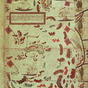
Premium Framed Print : Map of India and Indian Ocean, from Miller Atlas by Pedro and Jorge Reinel, Lopo Homen, cartographers and Antonio de Holanda, miniaturist, 1519


![]()
Framed Photos from Universal Images Group (UIG)
Map of India and Indian Ocean, from Miller Atlas by Pedro and Jorge Reinel, Lopo Homen, cartographers and Antonio de Holanda, miniaturist, 1519
Cartography, 16th century. Map of India and Indian Ocean, from Miller Atlas, by Pedro and Jorge Reinel, Lopo Homen (cartographers) and Antonio de Holanda (miniaturist), 1519
Universal Images Group (UIG) manages distribution for many leading specialist agencies worldwide
Media ID 9505413
© DEA / J. E. BULLOZ
16th Century Barge Coastline Compass Rose Direction Guidance India Indian Ocean Nautical Vessel Sailing Ship Sign Symbol
17"x15" (43x38cm) Premium Frame
FSC real wood frame with double mounted 10x8 print. Double mounted with white conservation mountboard. Frame moulding comprises stained composite natural wood veneers (Finger Jointed Pine) 39mm wide by 21mm thick. Archival quality Fujifilm CA photo paper mounted onto 1mm card. Overall outside dimensions are 17x15 inches (431x381mm). Rear features Framing tape to cover staples, 50mm Hanger plate, cork bumpers. Glazed with durable thick 2mm Acrylic to provide a virtually unbreakable glass-like finish. Acrylic Glass is far safer, more flexible and much lighter than typical mineral glass. Moreover, its higher translucency makes it a perfect carrier for photo prints. Acrylic allows a little more light to penetrate the surface than conventional glass and absorbs UV rays so that the image and the picture quality doesn't suffer under direct sunlight even after many years. Easily cleaned with a damp cloth. Please note that, to prevent the paper falling through the mount window and to prevent cropping of the original artwork, the visible print may be slightly smaller to allow the paper to be securely attached to the mount without any white edging showing and to match the aspect ratio of the original artwork.
FSC Real Wood Frame and Double Mounted with White Conservation Mountboard - Professionally Made and Ready to Hang
Estimated Image Size (if not cropped) is 24.4cm x 17cm (9.6" x 6.7")
Estimated Product Size is 43.1cm x 38.1cm (17" x 15")
These are individually made so all sizes are approximate
Artwork printed orientated as per the preview above, with landscape (horizontal) orientation to match the source image.
FEATURES IN THESE COLLECTIONS
> Arts
> Artists
> O
> Oceanic Oceanic
> Arts
> Artists
> R
> Pedro Reinel
> Asia
> India
> Related Images
> Maps and Charts
> India
> Maps and Charts
> Related Images
> Universal Images Group (UIG)
> Art
> Painting, Sculpture & Prints
> Cartography
EDITORS COMMENTS
This print showcases a remarkable piece of cartographic history - the Map of India and Indian Ocean from the Miller Atlas, created by Pedro and Jorge Reinel, Lopo Homen (cartographers), and Antonio de Holanda (miniaturist) in 1519. The image transports us back to the 16th century, where exploration and colonialism were at their peak. The map itself is a testament to human curiosity and the thirst for knowledge during this era. It provides valuable guidance for sailors navigating through uncharted waters, with its intricate compass rose indicating cardinal directions. The detailed coastline outlines offer insight into the geographical features of India and its surrounding regions. In this particular scene, we see a signpost erected on an idyllic shoreline overlooking the vast Indian Ocean. A majestic sailing ship gracefully glides across the water's surface while exotic animal motifs adorn both land and sea. People gather around, perhaps seeking direction or marveling at this extraordinary work of art that encapsulates their world. As we gaze upon this historical masterpiece captured in vibrant colors against a clear blue sky, we are reminded of our connection to those who came before us - explorers who braved unknown territories in search of new horizons. This photograph serves as a visual time capsule, inviting us to reflect on our shared human history while appreciating the beauty and significance of ancient cartography.
MADE IN THE UK
Safe Shipping with 30 Day Money Back Guarantee
FREE PERSONALISATION*
We are proud to offer a range of customisation features including Personalised Captions, Color Filters and Picture Zoom Tools
SECURE PAYMENTS
We happily accept a wide range of payment options so you can pay for the things you need in the way that is most convenient for you
* Options may vary by product and licensing agreement. Zoomed Pictures can be adjusted in the Basket.