Tote Bag > Europe > France > Canton > Landes
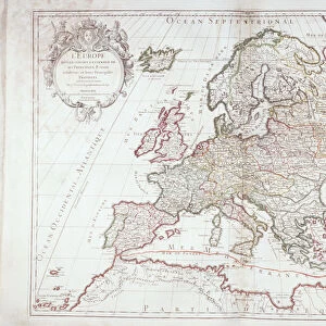
Tote Bag : 1706, De La Feuille Map of Europe, topography, cartography, geography, land, illustration


![]()
Home Decor from Liszt Collection
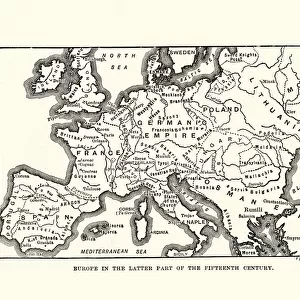
1706, De La Feuille Map of Europe, topography, cartography, geography, land, illustration
1706, De La Feuille Map of Europe
Liszt Collection of nineteenth-century engravings and images to browse and enjoy
Media ID 14006849
© Artokoloro Quint Lox Limited
1706 Antique Map Atlas Chart Geographic Latitude Longitude Mappa Mundi Old Antique Plan Old Antique View Old Map Ols Antique Map Rare Old Maps Topo
Canvas Tote Bag
Our tote bags are made from soft, durable, poly-poplin fabric and include a one inch (2.5cm) black strap for easy carrying on your shoulder. All seams are double-stitched for added durability. Each tote bag is machine-washable in cold water and is printed on both sides using the same image. Approximate size of bag is 50x33cm (20"x13")
Our tote bags are made from soft durable fabric and include a strap for easy carrying
Estimated Product Size is 50cm x 32.7cm (19.7" x 12.9")
These are individually made so all sizes are approximate
FEATURES IN THESE COLLECTIONS
> Europe
> France
> Canton
> Landes
> Historic
> Space exploration
> Maps and Charts
> Early Maps
> Maps and Charts
> Related Images
> Maps and Charts
> World
EDITORS COMMENTS
This print showcases the exquisite 1706 De La Feuille Map of Europe, a true masterpiece in the realms of topography, cartography, and geography. With its intricate details and precise measurements, this illustration offers a glimpse into the land formations and geographic features that shaped Europe centuries ago. The vintage charm of this ancient map is evident through its delicate paper texture and retro aesthetic. Its historical significance cannot be overstated as it provides valuable insights into the world as it was known back then. This decorative piece takes us on a journey through time, inviting us to explore the uncharted territories of yesteryears. As we delve into this old antique view, we are reminded of the great explorations and discoveries that took place during that era. The mappa mundi depicted here serves as a testament to human curiosity and our relentless pursuit of knowledge about our planet's diverse regions. With its carefully plotted grid lines representing latitude and longitude, this map becomes more than just an artistic creation; it transforms into a navigational tool for those seeking adventure or studying history. It stands as a rare gem among old maps—a window into an age long gone but not forgotten.
MADE IN THE UK
Safe Shipping with 30 Day Money Back Guarantee
FREE PERSONALISATION*
We are proud to offer a range of customisation features including Personalised Captions, Color Filters and Picture Zoom Tools
SECURE PAYMENTS
We happily accept a wide range of payment options so you can pay for the things you need in the way that is most convenient for you
* Options may vary by product and licensing agreement. Zoomed Pictures can be adjusted in the Basket.