Home > Science > Space Exploration > Satellite Imagery
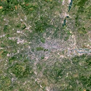
London, true-colour satellite image C016 / 3888

![]()
Wall Art and Photo Gifts from Science Photo Library
London, true-colour satellite image C016 / 3888
London and its surrounds, true-colour satellite image. North is at top. The Thames Estuary is at right. London is the capital city of the UK. It has been the largest and most populous city in Europe since the 17th century, and is a major financial and cultural centre. The centre of London is at centre left, with the Thames flowing through it towards the estuary. The area shown here is around 170 kilometres across, and includes extensive areas of fields. Image data obtained on 13 September 2002 by the Enhanced Thematic Mapper Plus (bands 3, 2, 1) on NASAs Landsat 7 satellite. For infrared versions of this view, see images C016/3889 and C016/3890
Science Photo Library features Science and Medical images including photos and illustrations
Media ID 9204337
© NASA/ROBERT SIMMON/USGS/SCIENCE PHOTO LIBRARY
2002 Capital Cities City Coast Countryside Earth Observation Enhanced Thematic Mapper Plus Essex Fields From Space Greater London Human Geography Kent Land Land Cover Land Use Landsat 7 Largest London Natural Region Rivers Rural Satellite Satellite Image Sequence Series Suburban Surrey Thames Thames Estuary Town Towns True Colour Urban Built Up Middlesex South East England Surroundings Surrounds True Color
EDITORS COMMENTS
This print showcases a true-colour satellite image of London and its surrounds. With the North at the top, the Thames Estuary gracefully flows on the right side of the frame. As the capital city of the United Kingdom, London has held its position as Europe's largest and most populous city since the 17th century. Renowned for its financial prowess and cultural significance, this metropolis is depicted in all its glory. The heart of London sits prominently towards the center-left, with the iconic River Thames meandering through it before reaching out to embrace the estuary. The vastness captured in this image spans approximately 170 kilometers across, encompassing extensive fields that add a touch of rural beauty to an otherwise urban landscape. Obtained on September 13th, 2002 by NASA's Landsat 7 satellite using Enhanced Thematic Mapper Plus technology (bands 3,2,1), this photograph offers a glimpse into London's intricate tapestry from space. It provides valuable insight into land use patterns and covers Greater London along with surrounding areas such as Middlesex, Surrey, Essex, Kent - showcasing both built-up urban regions and picturesque countryside. This remarkable visual representation serves as a testament to human geography in England during our modern era. Its breathtaking details reveal how cities have evolved over time while harmonizing with their natural surroundings. A truly awe-inspiring piece capturing one of Europe's most vibrant cities from above.
MADE IN THE UK
Safe Shipping with 30 Day Money Back Guarantee
FREE PERSONALISATION*
We are proud to offer a range of customisation features including Personalised Captions, Color Filters and Picture Zoom Tools
SECURE PAYMENTS
We happily accept a wide range of payment options so you can pay for the things you need in the way that is most convenient for you
* Options may vary by product and licensing agreement. Zoomed Pictures can be adjusted in the Basket.