Home > Science > Space Exploration > Satellite Imagery
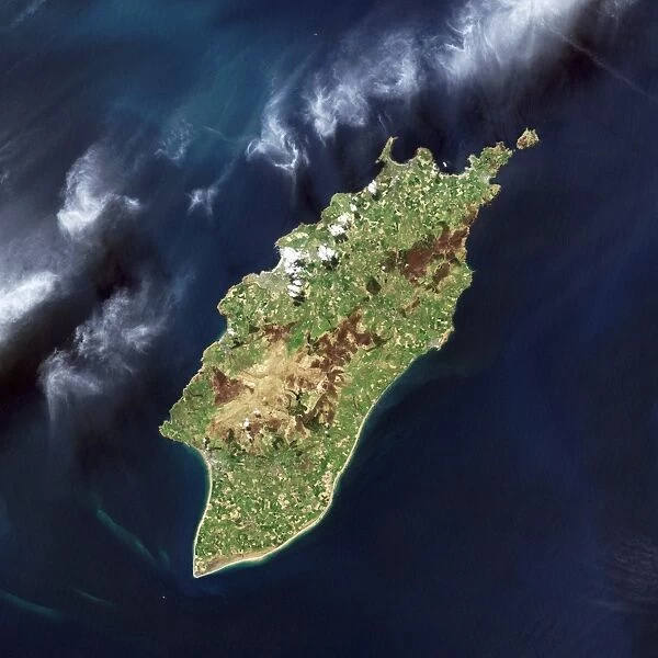
Isle of Man, satellite image C016 / 3886
![]()

Wall Art and Photo Gifts from Science Photo Library
Isle of Man, satellite image C016 / 3886
Isle of Man, satellite image. North is at bottom. Visible features include fields and hills (shades of green), beaches and barren or dry areas (brown), clouds (white, across upper left), lakes and reservoirs (dark blue), and urban areas (grey). The Isle of Man is a self-governing British Crown Dependency in the Irish Sea between Great Britain and Ireland. It has been inhabited since 6500 BC, with a current population of around 85, 000. It is 52 kilometres long, and 22 kilometres wide at its widest point. The capital and largest town is Douglas (upper left). Image obtained on 1 May 2001 by the Enhanced Thematic Mapper Plus on NASAs Landsat 7 satellite
Science Photo Library features Science and Medical images including photos and illustrations
Media ID 9204313
© NASA/ROBERT SIMMON/USGS/SCIENCE PHOTO LIBRARY
2001 Agriculture Beach Beaches Cloud Clouds Coast Coastal Country Farming Farms Field Fields From Space Great Britain Harbour Hill Hills Human Geography Irish Sea Island Land Cover Land Use Landsat 7 Natural Optical Physical Geography Port Satellite Satellite Image Terrain Topography Town Towns True Colour Vegetation Visible Isle Of Man Mann True Color
EDITORS COMMENTS
This print showcases the stunning Isle of Man, a self-governing British Crown Dependency nestled in the Irish Sea between Great Britain and Ireland. Taken on 1 May 2001 by NASA's Landsat 7 satellite, this true color image offers a bird's-eye view of the island's diverse features. At first glance, one can appreciate the picturesque landscape with its lush green fields and rolling hills that dominate much of the terrain. The brown patches represent barren or dry areas, providing an interesting contrast to the vibrant greens. Alongside these natural elements are beautiful beaches that line the coast, offering a serene escape for locals and visitors alike. The presence of lakes and reservoirs is evident through their dark blue hues, while urban areas are depicted in shades of grey. The capital city Douglas stands out prominently in the upper left corner as a bustling hub of activity amidst this tranquil setting. As we explore further into this image, clouds drift across the upper left portion like delicate brushstrokes on a canvas. This snapshot from space also highlights how human activities have shaped the land over time with evidence of farming practices visible throughout. With its rich history dating back to 6500 BC and a current population of around 85,000 people, Isle of Man truly embodies both natural beauty and cultural heritage. This remarkable photograph serves as a testament to our ability to capture Earth's wonders from above using advanced satellite technology.
MADE IN THE UK
Safe Shipping with 30 Day Money Back Guarantee
FREE PERSONALISATION*
We are proud to offer a range of customisation features including Personalised Captions, Color Filters and Picture Zoom Tools
SECURE PAYMENTS
We happily accept a wide range of payment options so you can pay for the things you need in the way that is most convenient for you
* Options may vary by product and licensing agreement. Zoomed Pictures can be adjusted in the Basket.


