Home > Popular Themes > Geological
Europe, 3D artwork C015 / 6574

![]()
Wall Art and Photo Gifts from Science Photo Library
Europe, 3D artwork C015 / 6574
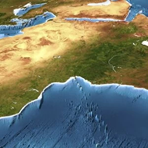
Europe. 3D computer graphic map of Europe and the surrounding sea floor in the Atlantic Ocean and Mediterranean Sea. Image based on cloud-free satellite imagery, digital terrain and bathymetry data. The land is shown in natural colour, based on a cloud-free composite of thousands of weather satellite images, but with height-exaggerated terrain and highlighted rivers and lakes. The sea is shown coloured by depth from white for the shallow continental shelves, to dark blue for the deep ocean trenches
Science Photo Library features Science and Medical images including photos and illustrations
Media ID 9213141
© PLANETARY VISIONS LTD/SCIENCE PHOTO LIBRARY
Atlantic Ocean Bathymetric Bathymetry Cartography Cloudless Coast Coastal Composite Image Continental Shelf Depth Depths Digital Terrain Data From Space Geological Height Heights Ireland Mediterranean Sea Mountain Mountainous Mountains North Sea Panorama Panoramic Peak Peaks Physical Geography Satellite Satellite Image Scandinavia Sea Floor Shelves Simulated Simulation Topographical Topography Weather Satellite
EDITORS COMMENTS
This print titled "Europe, 3D artwork C015 / 6574" takes us on a visual journey across the diverse landscapes of Europe. Created by PLANETARY VISIONS LTD in collaboration with Science Photo Library, this stunning piece of art showcases a computer-generated map of Europe and its surrounding sea floor. Using cloud-free satellite imagery, digital terrain data, and bathymetry information, the image beautifully captures the natural colors of the land while exaggerating its height to emphasize mountainous regions. Rivers and lakes are highlighted throughout the landscape, adding to the intricate details presented. The Atlantic Ocean and Mediterranean Sea come alive in shades ranging from white for shallow continental shelves to deep blue for ocean trenches. This color-coded representation based on depth allows viewers to appreciate the vastness and complexity of these bodies of water. From Scandinavia's majestic peaks to Britain's rugged coastlines, this panoramic view offers an immersive experience into Europe's geographical wonders. The topographical accuracy combined with simulated heights provides a unique perspective that is both educational and visually striking. Whether you are fascinated by physical geography or simply captivated by breathtaking scenery, this print invites you to explore Europe like never before. Let your imagination soar as you delve into this extraordinary work of art brought to life by PLANETARY VISIONS LTD/SCIENCE PHOTO LIBRARY.
MADE IN THE UK
Safe Shipping with 30 Day Money Back Guarantee
FREE PERSONALISATION*
We are proud to offer a range of customisation features including Personalised Captions, Color Filters and Picture Zoom Tools
SECURE PAYMENTS
We happily accept a wide range of payment options so you can pay for the things you need in the way that is most convenient for you
* Options may vary by product and licensing agreement. Zoomed Pictures can be adjusted in the Basket.