Premium Framed Print > Sheffield City Archives > Maps and Plans > Bowen's County Maps, c. 1777
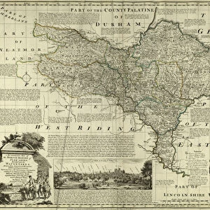
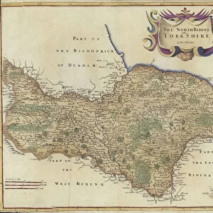
Premium Framed Print : County Map of Yorkshire, c. 1777


![]()
Framed Photos from Sheffield City Archives
County Map of Yorkshire, c. 1777
From The Large English Atlas: or, a new set of map of all the counties of England and Wales drawn from the several surveys which have been hitherto been published. With three general maps of England, Scotland and Ireland, from the latest and best authorities, by Emanuel Bowen, Thomas Kitchin and others. London, printed and sold by T. Bowles, [c.1777]
Original at Sheffield Libraries: 912 STF
Sheffield City Archives and Local Studies Library has an unrivalled collection of images of Sheffield, England
Media ID 25501553
© Sheffield City Council - All Rights Reserved
Antique Map Barnsley Bowens Map Bradfield Broomhall County Map Darnall Doncaster Ecclesfield Emanuel Bowen Heeley Old Map Owlerton Rotherham Sheffield Stannington Thomas Kitchin Tinsley Wadsley Wincobank Woodhouse York Yorkshire Acklam Beverley Bilton Bridlington Chapeltown Cleveland Flamborough Fulford Gleadless Halifax Handsworth Helmsley Hornsey Howden Kingston Upon Hull Leeds Middlesbrough Pickering Pocklington Pontefract Richmond Rillington Robin Hoods Bay Scarborough Selby Shirecliffe Skipton Stillingfleet Tickhill Wakefield Whitby Wilton Yorkshire Dales
17"x15" (43x38cm) Premium Frame
FSC real wood frame with double mounted 10x8 print. Double mounted with white conservation mountboard. Frame moulding comprises stained composite natural wood veneers (Finger Jointed Pine) 39mm wide by 21mm thick. Archival quality Fujifilm CA photo paper mounted onto 1mm card. Overall outside dimensions are 17x15 inches (431x381mm). Rear features Framing tape to cover staples, 50mm Hanger plate, cork bumpers. Glazed with durable thick 2mm Acrylic to provide a virtually unbreakable glass-like finish. Acrylic Glass is far safer, more flexible and much lighter than typical mineral glass. Moreover, its higher translucency makes it a perfect carrier for photo prints. Acrylic allows a little more light to penetrate the surface than conventional glass and absorbs UV rays so that the image and the picture quality doesn't suffer under direct sunlight even after many years. Easily cleaned with a damp cloth. Please note that, to prevent the paper falling through the mount window and to prevent cropping of the original artwork, the visible print may be slightly smaller to allow the paper to be securely attached to the mount without any white edging showing and to match the aspect ratio of the original artwork.
FSC Real Wood Frame and Double Mounted with White Conservation Mountboard - Professionally Made and Ready to Hang
Estimated Image Size (if not cropped) is 24.4cm x 18.6cm (9.6" x 7.3")
Estimated Product Size is 43.1cm x 38.1cm (17" x 15")
These are individually made so all sizes are approximate
Artwork printed orientated as per the preview above, with landscape (horizontal) orientation to match the source image.
FEATURES IN THESE COLLECTIONS
> Sheffield City Archives
> Maps and Plans
> Bowen's County Maps, c. 1777
> Sheffield City Archives
> Maps and Plans
> Maps of Yorkshire
EDITORS COMMENTS
This print showcases the "County Map of Yorkshire" dating back to approximately 1777. A true antique gem, this map is part of "The Large English Atlas: or, a new set of maps of all the counties of England and Wales" meticulously crafted by renowned cartographers Emanuel Bowen, Thomas Kitchin, and others. Printed and sold in London by T. Bowles, this historical piece offers an intriguing glimpse into the past. Spanning across the vast expanse of Yorkshire, this map features notable towns and cities such as Halifax, Wakefield, Leeds, Sheffield, Doncaster, Pontefract, Whitby, Scarborough - just to name a few. It also highlights various regions within Yorkshire like Rotherham and Barnsley. With its intricate details and ornate design elements characteristic of its time period, this map transports us back to an era when cartography was both artistry and science. The original copy resides at Sheffield Libraries: 912 STF in Sheffield City Archives. Whether you are a history enthusiast or simply appreciate the beauty found in vintage maps like this one from Emanuel Bowen and Thomas Kitchin's collection; it serves as a fascinating window into Yorkshire's rich heritage. Let your imagination wander through centuries gone by as you explore each corner depicted on this remarkable piece that captures the essence of old-world charm.
MADE IN THE UK
Safe Shipping with 30 Day Money Back Guarantee
FREE PERSONALISATION*
We are proud to offer a range of customisation features including Personalised Captions, Color Filters and Picture Zoom Tools
SECURE PAYMENTS
We happily accept a wide range of payment options so you can pay for the things you need in the way that is most convenient for you
* Options may vary by product and licensing agreement. Zoomed Pictures can be adjusted in the Basket.