mail_outline sales@mediastorehouse.com
Framed Print
Antique Framed Print
Premium Framed Print
Canvas Print
Metal Print
Photographic Print
Poster Print
Fine Art Print
Mounted Print
Glass Frame
Acrylic Blox
Jigsaw Puzzle
Tote Bag
Photo Mug
Greetings Card
Postcard
Cushion
Mouse Mat
Glass Place Mat
Glass Coaster
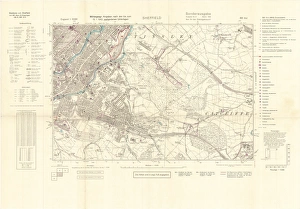
North Sheffield marked with bombing targets, c. 1940Full title: Ordnance Survey map of north Sheffield copied by the Germans, and marked with bombing targets, c. 1940 Original at Sheffield Libraries: y06718
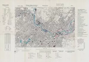
Ordnance Survey map of north Sheffield copied by the Germans, and marked with bombing targetsOriginal at Sheffield Local Studiess 26 M/4
Street map of Nether HallamUndated but before 1897 as it shows Hillsborough Hall and grounds which were acquired by the City Council in that year and the grounds opened as Hillsborough Park
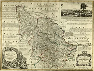
County Map of Yorkshire West Riding, c. 1777From The Large English Atlas: or, a new set of map of all the counties of England and Wales drawn from the several surveys which have been hitherto been published
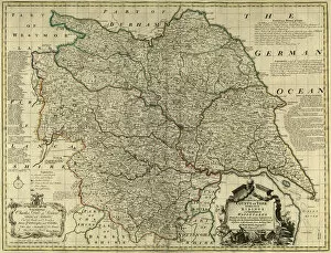
County Map of Yorkshire, c. 1777From The Large English Atlas: or, a new set of map of all the counties of England and Wales drawn from the several surveys which have been hitherto been published
Sheffield S5 8 MapPostcode Sector Map of Sheffield S5 8
A Map of Norwood Hall Estate in the Township of Brightside Bierlow and some adjoining Lands of the Duke of NorfolkNorwood Hall and Grounds (later known as Bishopholme), Norwood Lane later named Herries Road.Original at Sheffield Local Studies Library:s (15) 1 L
Longley estate, Sheffield, 1930sFrom an original at Sheffield Libraries: u09823