Framed Print > Sheffield City Archives > Maps and Plans > Bowen's County Maps, c. 1777
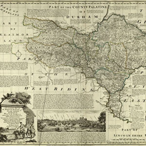
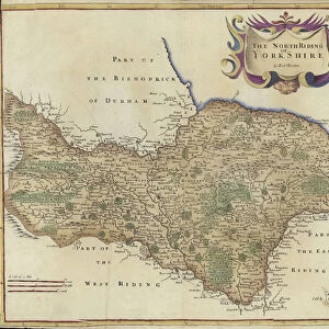
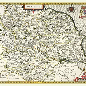
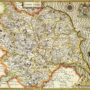
Framed Print : County Map of Yorkshire, c. 1777


![]()
Framed Photos from Sheffield City Archives
County Map of Yorkshire, c. 1777
From The Large English Atlas: or, a new set of map of all the counties of England and Wales drawn from the several surveys which have been hitherto been published. With three general maps of England, Scotland and Ireland, from the latest and best authorities, by Emanuel Bowen, Thomas Kitchin and others. London, printed and sold by T. Bowles, [c.1777]
Original at Sheffield Libraries: 912 STF
Sheffield City Archives and Local Studies Library has an unrivalled collection of images of Sheffield, England
Media ID 25501553
© Sheffield City Council - All Rights Reserved
Antique Map Barnsley Bowens Map Bradfield Broomhall County Map Darnall Doncaster Ecclesfield Emanuel Bowen Heeley Old Map Owlerton Rotherham Sheffield Stannington Thomas Kitchin Tinsley Wadsley Wincobank Woodhouse York Yorkshire Acklam Beverley Bilton Bridlington Chapeltown Cleveland Flamborough Fulford Gleadless Halifax Handsworth Helmsley Hornsey Howden Kingston Upon Hull Leeds Middlesbrough Pickering Pocklington Pontefract Richmond Rillington Robin Hoods Bay Scarborough Selby Shirecliffe Skipton Stillingfleet Tickhill Wakefield Whitby Wilton Yorkshire Dales
14"x12" (38x32cm) Modern Frame
Discover the rich history of Yorkshire with our exquisite framed print from Media Storehouse. This stunning reproduction showcases an original County Map of Yorkshire, dated c. 1777, taken from The Large English Atlas. Each detail in this antique map reflects the intricacies of the region's geography during that era, making it a captivating addition to your home or office decor. The high-quality print is carefully framed to preserve its authenticity and beauty, guaranteeing a timeless piece that tells a story of Yorkshire's past. Bring history to life with this unique and sophisticated framed print from Media Storehouse.
Wood effect frame, card mounted, 10x8 archival quality photo print. Overall outside dimensions 14x12 inches (38x32cm). Environmentally and ozone friendly, 40mm wide x 15mm Polycore® moulding has the look of real wood, is durable and light and easy to hang. Biodegradable and made with non-chlorinated gases (no toxic fumes) it is efficient; producing 100 tons of polystyrene can save 300 tons of trees! Prints are glazed with lightweight, shatterproof, optical clarity acrylic (providing the same general protection from the environment as glass). The back is stapled hardboard with a sawtooth hanger attached. Note: To minimise original artwork cropping, for optimum layout, and to ensure print is secure, the visible print may be marginally smaller
Contemporary Framed and Mounted Prints - Professionally Made and Ready to Hang
Estimated Image Size (if not cropped) is 24.4cm x 18.6cm (9.6" x 7.3")
Estimated Product Size is 37.6cm x 32.5cm (14.8" x 12.8")
These are individually made so all sizes are approximate
Artwork printed orientated as per the preview above, with landscape (horizontal) orientation to match the source image.
FEATURES IN THESE COLLECTIONS
> Sheffield City Archives
> Maps and Plans
> Bowen's County Maps, c. 1777
> Sheffield City Archives
> Maps and Plans
> Maps of Yorkshire
EDITORS COMMENTS
This print showcases the "County Map of Yorkshire" dating back to approximately 1777. A true antique gem, this map is part of "The Large English Atlas: or, a new set of maps of all the counties of England and Wales" meticulously crafted by renowned cartographers Emanuel Bowen, Thomas Kitchin, and others. Printed and sold in London by T. Bowles, this historical piece offers an intriguing glimpse into the past. Spanning across the vast expanse of Yorkshire, this map features notable towns and cities such as Halifax, Wakefield, Leeds, Sheffield, Doncaster, Pontefract, Whitby, Scarborough - just to name a few. It also highlights various regions within Yorkshire like Rotherham and Barnsley. With its intricate details and ornate design elements characteristic of its time period, this map transports us back to an era when cartography was both artistry and science. The original copy resides at Sheffield Libraries: 912 STF in Sheffield City Archives. Whether you are a history enthusiast or simply appreciate the beauty found in vintage maps like this one from Emanuel Bowen and Thomas Kitchin's collection; it serves as a fascinating window into Yorkshire's rich heritage. Let your imagination wander through centuries gone by as you explore each corner depicted on this remarkable piece that captures the essence of old-world charm.
MADE IN THE UK
Safe Shipping with 30 Day Money Back Guarantee
FREE PERSONALISATION*
We are proud to offer a range of customisation features including Personalised Captions, Color Filters and Picture Zoom Tools
SECURE PAYMENTS
We happily accept a wide range of payment options so you can pay for the things you need in the way that is most convenient for you
* Options may vary by product and licensing agreement. Zoomed Pictures can be adjusted in the Basket.