Home > Arts > Artists > S > John Speed
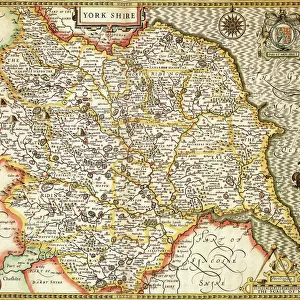
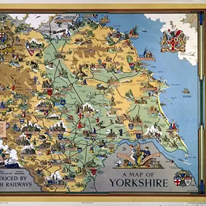
Old County Map of Yorkshire 1611 by John Speed

![]()
Wall Art and Photo Gifts from MapSeeker
Old County Map of Yorkshire 1611 by John Speed
A facimile of John Speeds historical map of Yorkshire originally published for the " Theatre of the Empire of Great Britain", an atlas to accompany " a history of Great Britain"
Welcome to the Mapseeker Image library and enter an historic gateway to one of the largest on-line collections of Historic Maps, Nostalgic Views, Vista's and Panorama's from a World gone by.
Media ID 20347814
© Mapseeker Publishing Ltd
County Map County Map Of England English County Map Historic Map John Speed Map Old County Map Old English County Map Speed Map Speede Map
FEATURES IN THESE COLLECTIONS
> Arts
> Artists
> S
> John Speed
> Europe
> United Kingdom
> England
> Maps
> Europe
> United Kingdom
> England
> Yorkshire
> Related Images
> Maps and Charts
> British Empire Maps
> Maps and Charts
> Early Maps
> Maps and Charts
> Related Images
> MapSeeker
> Maps from the British Isles
> England and Counties PORTFOLIO
EDITORS COMMENTS
This print showcases the "Old County Map of Yorkshire 1611" by John Speed, a remarkable facsimile of his historical map originally published for the "Theatre of the Empire of Great Britain". This exquisite atlas was created to accompany a comprehensive history of Great Britain. With its intricate details and artistic flair, this old English county map takes us back in time to explore the rich heritage and geographical features of Yorkshire. The masterful craftsmanship employed by John Speed is evident in every stroke, as he meticulously captures the essence of this historic region. As we delve into this mesmerizing piece, we are transported to an era where cartography was both an art form and a scientific endeavor. The delicate lines trace ancient boundaries while vibrant colors bring life to towns, rivers, and landmarks that have shaped Yorkshire's past. This historical gem not only serves as a testament to John Speed's talent but also provides invaluable insights into England's county maps during that period. It allows us to appreciate how our understanding of geography has evolved over centuries. Whether you are an avid historian or simply captivated by beautiful cartography, this print offers a window into Yorkshire's past like no other. Let it adorn your walls and spark conversations about our shared heritage with friends and family alike.
MADE IN THE UK
Safe Shipping with 30 Day Money Back Guarantee
FREE PERSONALISATION*
We are proud to offer a range of customisation features including Personalised Captions, Color Filters and Picture Zoom Tools
SECURE PAYMENTS
We happily accept a wide range of payment options so you can pay for the things you need in the way that is most convenient for you
* Options may vary by product and licensing agreement. Zoomed Pictures can be adjusted in the Basket.