Premium Framed Print > Europe > Portugal > Maps
Premium Framed Print : Medieval Spain and Portugal map


![]()
Framed Photos from North Wind
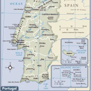
Medieval Spain and Portugal map
Map of the Iberian Peninsula in the 1300s and 1400s.
Printed color lithograph reproduction of a 19th-century illustration
North Wind Picture Archives brings history to life with stock images and hand-colored illustrations
Media ID 5882217
© North Wind Picture Archives
1300s 1400s 14th Century 15th Century Europe European Granada Medieval Middle Ages Moors Portugal Portuguese Spain Spanish Aragon Castile Gibraltar Iberia Iberian Peninsula Navarra
17"x15" (43x38cm) Premium Frame
FSC real wood frame with double mounted 10x8 print. Double mounted with white conservation mountboard. Frame moulding comprises stained composite natural wood veneers (Finger Jointed Pine) 39mm wide by 21mm thick. Archival quality Fujifilm CA photo paper mounted onto 1mm card. Overall outside dimensions are 17x15 inches (431x381mm). Rear features Framing tape to cover staples, 50mm Hanger plate, cork bumpers. Glazed with durable thick 2mm Acrylic to provide a virtually unbreakable glass-like finish. Acrylic Glass is far safer, more flexible and much lighter than typical mineral glass. Moreover, its higher translucency makes it a perfect carrier for photo prints. Acrylic allows a little more light to penetrate the surface than conventional glass and absorbs UV rays so that the image and the picture quality doesn't suffer under direct sunlight even after many years. Easily cleaned with a damp cloth. Please note that, to prevent the paper falling through the mount window and to prevent cropping of the original artwork, the visible print may be slightly smaller to allow the paper to be securely attached to the mount without any white edging showing and to match the aspect ratio of the original artwork.
FSC Real Wood Frame and Double Mounted with White Conservation Mountboard - Professionally Made and Ready to Hang
Estimated Image Size (if not cropped) is 24.4cm x 17cm (9.6" x 6.7")
Estimated Product Size is 43.1cm x 38.1cm (17" x 15")
These are individually made so all sizes are approximate
Artwork printed orientated as per the preview above, with landscape (horizontal) orientation to match the source image.
FEATURES IN THESE COLLECTIONS
> North Wind Picture Archives
> Maps
> Arts
> Art Movements
> Medieval Art
> Europe
> Portugal
> Related Images
> Europe
> Spain
> Related Images
> Maps and Charts
> Related Images
EDITORS COMMENTS
This print takes us on a journey back in time to the medieval era of Spain and Portugal. With its vibrant colors and intricate details, it beautifully captures the essence of the Iberian Peninsula during the 1300s and 1400s. The map showcases the rich history and heritage of this region, highlighting key cities such as Granada, Gibraltar, Aragon, Castile, Navarra, and more. Each city is marked with precision, allowing us to trace the footsteps of ancient civilizations that once thrived here. As we explore this vintage illustration, we are transported to a world where traditional architecture meets European charm. The artistry behind this lithograph reproduction truly brings out the grandeur of medieval Spain and Portugal. One cannot help but marvel at how this map encapsulates centuries of cultural exchange between Christians and Moors. It serves as a testament to their coexistence during these tumultuous times in history. Whether you are an art enthusiast or a history buff, this print offers a glimpse into Europe's fascinating past. It serves as a reminder that even amidst political turmoil and territorial disputes, beauty can be found in every corner of our shared human experience
MADE IN THE UK
Safe Shipping with 30 Day Money Back Guarantee
FREE PERSONALISATION*
We are proud to offer a range of customisation features including Personalised Captions, Color Filters and Picture Zoom Tools
SECURE PAYMENTS
We happily accept a wide range of payment options so you can pay for the things you need in the way that is most convenient for you
* Options may vary by product and licensing agreement. Zoomed Pictures can be adjusted in the Basket.