Fraud Blocker Skip to main content

Home > Arts > Artists > O > Oceanic Oceanic

EXPL2A-00352

EXPL2A-00352
Sold 117
In Stock
We accept all major payment options so you can pay for the things you need in the way that is most convenient for you

North Wind Photo Prints and Wall Art

EXPL2A-00352

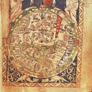
The Hereford Mappa Mundi of 1280 - Jerusalem is at the center, Europe lower left, Africa lower right.
Printed color halftone reproduction 19th century. North Wind Picture Archives brings history to life with stock images and hand-colored illustrations. © North Wind Picture Archives

Media ID 5881938

1200s 13th Century Africa Asia Cartography Document Earth Europe Flat Earth Jerusalem Medieval Mediterranean Mid East Middle Ages Navigation Ocean World World Map 1280 Flat Hereford Mappa Mundi

FEATURES IN THESE COLLECTIONS

> Arts > Art Movements > Medieval Art

> Arts > Artists > O > Oceanic Oceanic

> Maps and Charts > Africa

> Maps and Charts > Flat Earth

> Maps and Charts > Popular Maps

> Maps and Charts > Related Images

> Maps and Charts > World

> North Wind Picture Archives > Maps

> Popular Themes > Maps and Charts

SECURE PAYMENTS
We accept all major payment options so you can pay for the things you need in the way that is most convenient for you

Made in UK
Safe Shipping, Easy Returns

FREE PERSONALISATION
We are proud to offer a range of customisation including Cropping, Captions, and Filters. Zoom Cropping can be adjusted in the basket


EDITORS COMMENTS

This print showcases the EXPL2A-00352, also known as The Hereford Mappa Mundi of 1280. A true testament to medieval cartography, this vintage reproduction offers a glimpse into the world as it was perceived in the 13th century. At its heart lies Jerusalem, symbolizing its significance during that era. Europe is depicted in the lower left corner, while Africa graces the lower right side of this historic map. Printed with vibrant colors and halftone techniques in the 19th century, this illustration transports us back to a time when navigation relied on such intricate documents. The detailed representation of continents and oceans serves as a reminder of how early civilizations understood their place within the vastness of our planet. The Hereford Mappa Mundi not only provides geographical information but also reflects cultural beliefs prevalent during the Middle Ages. It captures an Earth where Asia stretches eastward towards unknown lands and where mythical creatures roam unexplored territories. As we gaze upon this remarkable piece of artistry, we are reminded of humanity's insatiable curiosity about our world's history and geography. This photograph invites us to appreciate both its aesthetic beauty and historical significance—a tangible connection to an age long past yet still relevant today.


Framed Prints

Introducing the stunning addition to our Framed Prints collection from Media Storehouse - EXPL2A-00352, a captivating image from North Wind Picture Archives. This exquisite print showcases the Hereford Mappa Mundi of 1280, an intricately detailed and historically significant medieval map. The centerpiece of the map is Jerusalem, surrounded by Europe to the left and Africa to the right. This 19th century, printed color halftone reproduction brings the rich history and intricate details of this ancient map to life in your home or office. Experience the allure of the past with this beautiful and educational piece.


Photo Prints

Introducing the Media Storehouse collection of historical photographic prints, featuring the captivating image EXPL2A-00352 from North Wind Picture Archives. This remarkable print showcases the Hereford Mappa Mundi, a 13th-century medieval world map, with Jerusalem at its center. Europe is depicted to the lower left, and Africa to the lower right. Our high-quality, color halftone reproduction brings the intricate details and rich history of this 19th-century print to life. Travel back in time and add this unique piece to your collection.


Poster Prints

Introducing the Media Storehouse's stunning collection of poster prints from North Wind Picture Archives. This captivating piece features the intricately detailed Hereford Mappa Mundi of 1280, with Jerusalem at its center. Europe is depicted to the lower left, and Africa to the lower right. Each print is meticulously reproduced using color halftone technology, faithfully preserving the original 19th century charm. Transport yourself back in time with this awe-inspiring representation of historical cartography. Add this beautiful print to your home or office to inspire wonder and curiosity.


Jigsaw Puzzles

Discover the wonders of medieval cartography with our captivating jigsaw puzzle from Media Storehouse, featuring the intricately detailed Hereford Mappa Mundi of 1280 - Jerusalem. This vintage reproduction from North Wind Picture Archives transports you back in time, showcasing Europe to the left and Africa to the right, with Jerusalem at the center. Immerse yourself in the rich history and intricate design of this 19th-century print, perfect for puzzle enthusiasts and history buffs alike. Unravel the mystery piece by piece and bring this historical masterpiece to life in your home.

diamond
Made With High Grade Materials
thumb_up
Professional Quality Finish
package_2
Carefully Packed To Aid Safe Arrival

You May Also Like


Al-Idrisis world map, 1154Al-Idrisis world map, 1154
Add to Basket
Thirteen original colonies in 1776Thirteen original colonies in 1776
Add to Basket
Antique map of Britain under the Anglo SaxonsAntique map of Britain under the Anglo Saxons
Add to Basket
Catalan Atlas, 14th centuryCatalan Atlas, 14th century
Add to Basket
Flat Earth map of the world showing it to be a planeFlat Earth map of the world showing it to be a plane
Add to Basket
Mappa Mundi, ink and colors on parchment, created in London about 1265Mappa Mundi, ink and colors on parchment, created in London about 1265
Add to Basket
Apostle Pauls Missionary Journeys, lithograph, published in 1886Apostle Pauls Missionary Journeys, lithograph, published in 1886
Add to Basket
Map of the Ancient Persian EmpireMap of the Ancient Persian Empire
Add to Basket
Mappa Mundi, c. 1290 (vellum)Mappa Mundi, c. 1290 (vellum)
Add to Basket
Bayeaux Tapestry portraying the Norman ConquestBayeaux Tapestry portraying the Norman Conquest
Add to Basket
Scotland map, 1870sScotland map, 1870s
Add to Basket
Iceland map, 1800sIceland map, 1800s
Add to Basket

Gallery Wall Inspiration

Thirteen original colonies in 1776
Newfoundland, 1870s
Map of ancient Rome
Vancouver Island map, 1870s
EXPL2A-00352
EXPL2A-00183
Iceland map, 1800s
Medieval Europe at the start of the Crusades
Map of England in 1066
Scotland map, 1870s
Map of England, 1800s
Ancient Greece and its colonies around the Aegean
Map of Britain in 597 AD
Erie Canal route
Medieval Spain and Portugal map
Ireland map, 1870s
Ancient Greek empire
Victoria province, Australia, 1800s
GGBR2A-00076
Map of ancient Palestine kingdoms of Judah and Israel
Maps of Italy in ancient times
Map of the Roman Empire
Traditional provinces of Spain
Map of Europe, 1870s
Caribbean islands, 1870s
Map of Europe under the Roman Empire
Map of Cape Colony, South Africa

Discover Our Collections


MapsMaps
View Collection
Flat EarthFlat Earth
View Collection
Maps and ChartsMaps and Charts
View Collection
Oceanic OceanicOceanic Oceanic
View Collection
Medieval ArtMedieval Art
View Collection
Maps and Charts Related ImagesMaps and Charts Related Images
View Collection
AfricaAfrica
View Collection
WorldWorld
View Collection
Popular MapsPopular Maps
View Collection


© Copyright Media Storehouse, All Rights Reserved 2003 - 2024
Facebook     Pinterest     100% Payment Secure     Reviews IO