Jigsaw Puzzle > Arts > Artists > O > Oceanic Oceanic
Jigsaw Puzzle : EXPL2A-00352


![]()
Jigsaw Puzzles from North Wind
EXPL2A-00352
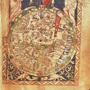
The Hereford Mappa Mundi of 1280 - Jerusalem is at the center, Europe lower left, Africa lower right.
Printed color halftone reproduction 19th century
North Wind Picture Archives brings history to life with stock images and hand-colored illustrations
Media ID 5881938
© North Wind Picture Archives
1200s 13th Century Africa Asia Cartography Document Earth Europe Flat Earth Jerusalem Medieval Mediterranean Mid East Middle Ages Navigation Ocean World World Map 1280 Flat Hereford Mappa Mundi
Jigsaw Puzzle (500 Pieces)
Discover the wonders of medieval cartography with our captivating jigsaw puzzle from Media Storehouse, featuring the intricately detailed Hereford Mappa Mundi of 1280 - Jerusalem. This vintage reproduction from North Wind Picture Archives transports you back in time, showcasing Europe to the left and Africa to the right, with Jerusalem at the center. Immerse yourself in the rich history and intricate design of this 19th-century print, perfect for puzzle enthusiasts and history buffs alike. Unravel the mystery piece by piece and bring this historical masterpiece to life in your home.
500 piece puzzles are custom made in the UK and hand-finished on 100% recycled 1.5 mm millboard. There is a level of repetition in jigsaw shapes with each matching piece away from its pair. The completed puzzle measures 38x50cm and is delivered packaged in an attractive presentation box specially designed to fit most letter box slots
Jigsaw Puzzles are an ideal gift for any occasion
Estimated Product Size is 38cm x 50.2cm (15" x 19.8")
These are individually made so all sizes are approximate
Artwork printed orientated as per the preview above, with portrait (vertical) orientation to match the source image.
FEATURES IN THESE COLLECTIONS
> Africa
> Related Images
> Arts
> Art Movements
> Medieval Art
> Arts
> Artists
> O
> Oceanic Oceanic
> Asia
> Related Images
> Maps and Charts
> Flat Earth
> Maps and Charts
> Popular Maps
> Maps and Charts
> Related Images
> Maps and Charts
> World
> Popular Themes
> Maps and Charts
> North Wind Picture Archives
> Maps
EDITORS COMMENTS
This print showcases the EXPL2A-00352, also known as The Hereford Mappa Mundi of 1280. A true testament to medieval cartography, this vintage reproduction offers a glimpse into the world as it was perceived in the 13th century. At its heart lies Jerusalem, symbolizing its significance during that era. Europe is depicted in the lower left corner, while Africa graces the lower right side of this historic map. Printed with vibrant colors and halftone techniques in the 19th century, this illustration transports us back to a time when navigation relied on such intricate documents. The detailed representation of continents and oceans serves as a reminder of how early civilizations understood their place within the vastness of our planet. The Hereford Mappa Mundi not only provides geographical information but also reflects cultural beliefs prevalent during the Middle Ages. It captures an Earth where Asia stretches eastward towards unknown lands and where mythical creatures roam unexplored territories. As we gaze upon this remarkable piece of artistry, we are reminded of humanity's insatiable curiosity about our world's history and geography. This photograph invites us to appreciate both its aesthetic beauty and historical significance—a tangible connection to an age long past yet still relevant today.
MADE IN THE UK
Safe Shipping with 30 Day Money Back Guarantee
FREE PERSONALISATION*
We are proud to offer a range of customisation features including Personalised Captions, Color Filters and Picture Zoom Tools
SECURE PAYMENTS
We happily accept a wide range of payment options so you can pay for the things you need in the way that is most convenient for you
* Options may vary by product and licensing agreement. Zoomed Pictures can be adjusted in the Basket.