Fraud Blocker Skip to main content

Home > Popular Themes > Maps and Charts

Maps and Charts Collection

Maps and charts are popular themes used in various fields such as geography, history, science, and education

Choose a picture from our Maps and Charts Collection for your Wall Art and Photo Gifts

44 items

Background imageMaps and Charts Collection: Thirteen original colonies in 1776

Thirteen original colonies in 1776
American colonies at the outbreak of the Revolution. Printed color lithograph of a 19th-century illustration

Background imageMaps and Charts Collection: William Smith Geological Map

William Smith Geological Map

Background imageMaps and Charts Collection: Map of Ancient Greece

Map of Ancient Greece
A map showing the extent of the Greek Empire and the surrounding territories

Background imageMaps and Charts Collection: Flat Earth map of the world showing it to be a plane

Flat Earth map of the world showing it to be a plane
A MAP OF THE WORLD SHOWING IT TO BE A PLANE - and those of us who suppose it to be a globe are clearly mistaken. Date: 1893

Background imageMaps and Charts Collection: EXPL2A-00352

EXPL2A-00352
The Hereford Mappa Mundi of 1280 - Jerusalem is at the center, Europe lower left, Africa lower right. Printed color halftone reproduction 19th century

Background imageMaps and Charts Collection: Antique map of Britain under the Anglo Saxons

Antique map of Britain under the Anglo Saxons

Background imageMaps and Charts Collection: Mappa Mundi, ink and colors on parchment, created in London about 1265

Mappa Mundi, ink and colors on parchment, created in London about 1265
Cartography, 13th century. Mappa Mundi, Medieval map, London about 1265. Ink and colors on parchment. The maps diameter is 9 cm

Background imageMaps and Charts Collection: Map of the British Empire

Map of the British Empire
The Howard Vincent map of the British Empire, 1897 Date: 1897

Background imageMaps and Charts Collection: Map of the British Empire

Map of the British Empire
The Howard Vincent map of the British Empire, 1897 Date: 1897

Background imageMaps and Charts Collection: Maps / Jamaica

Maps / Jamaica
Maps/Jamaica

Background imageMaps and Charts Collection: Daily Mail War Map, WW1

Daily Mail War Map, WW1
A fold out war map issued by the Daily Mail in the early weeks of the First World War. The map offers statistics regarding the manpower strength of each of the warring nations

Background imageMaps and Charts Collection: Map of ancient Rome

Map of ancient Rome
City plan of ancient Rome. Lithograph

Background imageMaps and Charts Collection: Cornwall map 1884

Cornwall map 1884
Encyclopedia Britannica 9th Edition New York Charles Scribners and Sons 1884 Vol VI

Background imageMaps and Charts Collection: Iceland map, 1800s

Iceland map, 1800s
Map of Iceland, 1870s. Printed color lithograph reproduction of a 19th-century illustratioin

Background imageMaps and Charts Collection: Scotland map, 1870s

Scotland map, 1870s
Map of Scotland, 1870s. Printed color lithograph

Background imageMaps and Charts Collection: Map / Isle of Wight C1857

Map / Isle of Wight C1857
Map of the Isle of Wight (County series)

Background imageMaps and Charts Collection: Europe Map C1914

Europe Map C1914
The map of Europe on the eve of World War One

Background imageMaps and Charts Collection: Ireland map, 1870s

Ireland map, 1870s
Map of Ireland, or Eire, 1870s. Printed color lithograph

Background imageMaps and Charts Collection: Map / Asia / Mongol Empire

Map / Asia / Mongol Empire
The Mongol Empire at its greatest extent : commenced by Genghis Khan in the 13th century, it was enlarged by Kublai Khan but broke up after about 1380

Background imageMaps and Charts Collection: Crusades Map

Crusades Map
A map of Europe depicting the paths of various Crusades between 1096 and 1270

Background imageMaps and Charts Collection: Treasure Island Map / Col

Treasure Island Map / Col
A map of Treasure Island

Background imageMaps and Charts Collection: Map / Asia / India C1870

Map / Asia / India C1870
India, showing the various Presidencies under British rule

Background imageMaps and Charts Collection: Map of The Byzantine Empire

Map of The Byzantine Empire
A map showing the extent of the Byzantine Empire - the predominantly Greek-speaking continuation of the Roman Empire during Late Antiquity and the Middle Ages. Date: 1800

Background imageMaps and Charts Collection: Map / Arctic Circle 1895

Map / Arctic Circle 1895
Map of the Arctic Circle and surrounding areas

Background imageMaps and Charts Collection: Ukraine country map

Ukraine country map
2011 edition

Background imageMaps and Charts Collection: Medieval Europe at the start of the Crusades

Medieval Europe at the start of the Crusades
Map of Europe at the time of the First Crusade, 1097 AD. Printed color lithograph of a 19th-century illustration

Background imageMaps and Charts Collection: Viking Britain Map

Viking Britain Map
A map of the British Isles (including Ireland) during the time of the Vikings

Background imageMaps and Charts Collection: Avebury / Stukeley Map

Avebury / Stukeley Map
A beautifully drawn overhead plan of the stone circles and embankment ditches at Avebury. Stukeleys accuracy is impressive, charting every stone, pasture and building

Background imageMaps and Charts Collection: Map of the Empire of King Alexander the Great

Map of the Empire of King Alexander the Great (Alexander III of Macedon 356323 BC), from Greece in the west to India in the east. Date: 1807

Background imageMaps and Charts Collection: Map of the Ancient Persian Empire

Map of the Ancient Persian Empire, encompassing Greece to the north west, Arabia to the south east, Egypt and Libya to the south west and deep in the Caucasus in the north east. Date: 1798

Background imageMaps and Charts Collection: Denver, Colorado area map

Denver, Colorado area map
2011 edition

Background imageMaps and Charts Collection: York Cold War Bunker N070184

York Cold War Bunker N070184
YORK COLD WAR BUNKER, North Yorkshire. Interior view of the Operations Room showing maps and charts ready for use

Background imageMaps and Charts Collection: Map of Valois, 1926 (print)

Map of Valois, 1926 (print)
3786712 Map of Valois, 1926 (print) by Blaeu, Willem (1571-1638) and Joan (1596-1673); Private Collection; (add.info.: by Willem and Joan Blaeu)

Background imageMaps and Charts Collection: ace1976 bw neg 007

ace1976 bw neg 007

Background imageMaps and Charts Collection: 13820760

13820760

Background imageMaps and Charts Collection: 13820724

13820724

Background imageMaps and Charts Collection: The World - map engraved by Johannes Schnitzer

The World - map engraved by Johannes Schnitzer
3786531 The World - map engraved by Johannes Schnitzer; (add.info.: The World - map engraved by Johannes Schnitzer de Armssheim, cartographer of Ptolemys Geography, 1482)

Background imageMaps and Charts Collection: The World, 1482 (engraving)

The World, 1482 (engraving)
3787416 The World, 1482 (engraving); (add.info.: The World - map engraved by Johannes Schnitzer de Armssheim, cartographer of Ptolemys Geography, 1482)

Background imageMaps and Charts Collection: Map of the Coast of Guiana, 1646-47

Map of the Coast of Guiana, 1646-47
3786720 Map of the Coast of Guiana, 1646-47; (add.info.: Map of the Coast of Guiana - published in Dudleys Dell Arcano del Mare, 1646- 47)

Background imageMaps and Charts Collection: Map of Old and New Virginia, 1646-47

Map of Old and New Virginia, 1646-47
3786721 Map of Old and New Virginia, 1646-47; (add.info.: Map of Old and New Virginia - published in Dudleys Dell Arcano del Mare, 1646- 47)

Background imageMaps and Charts Collection: Map of Palestine, 1926 (colour litho)

Map of Palestine, 1926 (colour litho)
3482908 Map of Palestine, 1926 (colour litho) by Trietsch, Davis (1870-1935); Private Collection; (add.info.: PalAastina-Wirtschafts-Atlas. Berlin: Orient-Verlag, [1926])

Background imageMaps and Charts Collection: FAF pilots study maps and charts before taking a flight in an Avro Anson for their

FAF pilots study maps and charts before taking a flight in an Avro Anson for their training lesson at a station in England during the Second World War. 3rd October 1939

Background imageMaps and Charts Collection: Panoramic view of the Baltic Sea and the Route of the Fleet from Spithead to St. Petersburg

Panoramic view of the Baltic Sea and the Route of the Fleet from Spithead to St. Petersburg
XND70123 Panoramic view of the Baltic Sea and the Route of the Fleet from Spithead to St. Petersburg, from government maps

Background imageMaps and Charts Collection: ACAPULCO, 1650. View of the harbor of Acapulco, Mexico

ACAPULCO, 1650. View of the harbor of Acapulco, Mexico. Watercolor by Johannes Vingboons from the Vingboons atlas, Amsterdam, c1650-70, a collection of sea maps and charts of harbors outside Europe


All Professionally Made to Order for Quick Shipping


-

Maps and Charts Collection

Maps and charts are popular themes used in various fields such as geography, history, science, and education. Maps provide a visual representation of geographical locations and features while charts present data in an organized manner for easy comprehension. They help to communicate complex information effectively by simplifying it into a clear format that can be easily understood. They have been used for centuries to aid navigation, plan routes, track weather patterns, analyze trends and patterns in data among other things. With the advancement of technology, digital maps and interactive charts have become more common making them even more accessible to people all over the world.
+

Our beautiful pictures are available as Framed Prints, Photos, Wall Art and Photo Gifts

The Maps and Charts collection from Media Storehouse is a stunning array of wall art and framed prints that showcase some of the most beautiful maps and charts from around the world. Our collection features an extensive range of themes, including vintage maps, nautical charts, city plans, topographical maps, and more. Each print in our collection has been carefully curated to offer a unique perspective on geography and history. Whether you're looking for a classic map of your hometown or an intricate chart of the ocean floor, there's something here for everyone. These high-quality prints are available in a variety of sizes and styles to suit any decor style. They make excellent gifts for anyone who loves travel or history or as an addition to your own home decor. The Maps and Charts collection from Media Storehouse is a must-see for anyone interested in cartography or looking to add some unique wall art to their home.
+

What are Maps and Charts (Popular Themes) art prints?

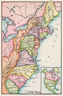
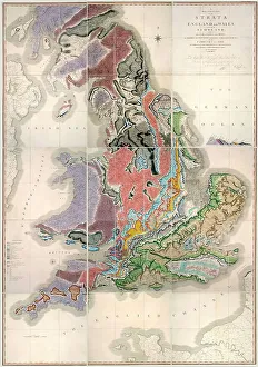
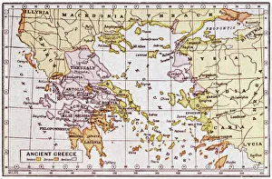
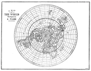
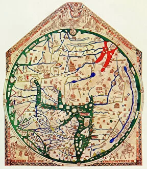
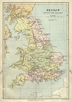
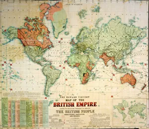
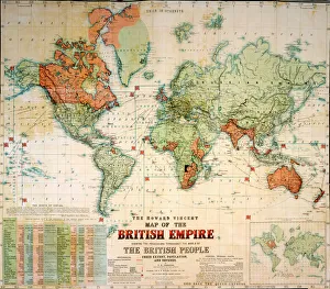
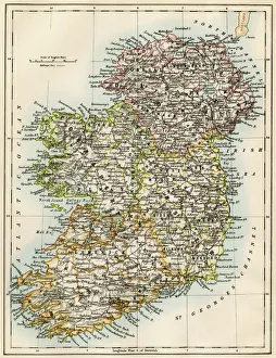
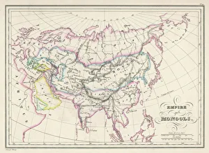
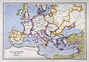
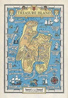
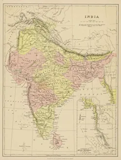
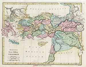
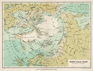
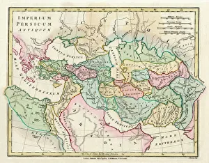
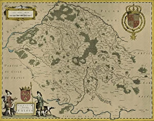
Maps and Charts art prints are a collection of high-quality reproductions of antique maps and charts that depict various regions, countries, oceans, and continents. These prints showcase the intricate details of these historical documents, including coastlines, mountains, rivers, cities, landmarks and other geographical features. These art prints are popular among history buffs who appreciate the beauty and accuracy of old cartography. They also make great decorative pieces for offices or homes with a vintage or nautical theme. The Maps and Charts collection includes works from renowned mapmakers such as Gerardus Mercator, Abraham Ortelius, John Speed and many others. The range covers different periods in history from the 16th to the 19th century. Whether you're looking to add some character to your living space or searching for an educational gift for someone interested in geography or history - Maps and Charts art prints offer something unique that will stand out on any wall.
+

What Maps and Charts (Popular Themes) art prints can I buy from Media Storehouse?

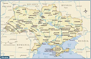
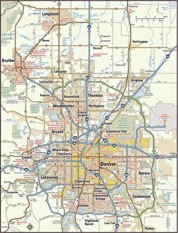
At Media Storehouse, you can find a vast collection of Maps and Charts art prints that are perfect for decorating your home or office. Whether you're looking for vintage maps, modern charts, or colorful illustrations, we have something to suit every taste and style. Our selection includes world maps, city maps, nautical charts, star charts, topographical maps, and more. You can choose from a variety of sizes and formats such as framed prints or canvas prints to fit your space perfectly. We also offer themed collections like antique maps of Europe or vintage travel posters that make great gifts for history buffs or travel enthusiasts. Our high-quality printing process ensures that the colors are vibrant and long-lasting so you can enjoy your art print for years to come. Browse our Maps and Charts collection today to find the perfect piece of wall art that will add character and charm to any room in your home.
+

How do I buy Maps and Charts (Popular Themes) art prints?

To purchase Maps and Charts art prints from Media Storehouse, you can browse our online gallery of available prints. Once you have found the print(s) that you would like to purchase, simply add them to your cart and proceed to checkout. During the checkout process, you will be prompted to enter your shipping information and payment details. We offer a variety of payment options including credit card, PayPal, and Amazon Pay. We also offer international shipping for customers outside of their home country. If you have any questions or concerns about purchasing Maps and Charts art prints from Media Storehouse, they have a customer service team available via email or phone who can assist with any inquiries. Buying art prints from Media Storehouse is a simple process that allows customers to easily find and purchase high-quality artwork in just a few clicks.
+

How much do Maps and Charts (Popular Themes) art prints cost?

The cost of Maps and Charts art prints varies depending on the size, type of paper, and framing options chosen. We offer a wide range of sizes for their art prints, from small to large formats. The price also depends on whether you choose a basic poster print or opt for a more premium quality fine art print. Additionally, if you decide to add framing to your purchase, this will increase the overall cost. However, We provide customers with various framing options to suit different tastes and budgets. The cost of Maps and Charts art prints can vary greatly depending on individual preferences. It is best to browse through our collection and select the size and type of print that suits your needs before determining its final cost.
+

How will my Maps and Charts (Popular Themes) art prints be delivered to me?

Your Maps and Charts art prints from Media Storehouse will be delivered to you in a safe and secure manner. The company takes great care in packaging your artwork so that it arrives at your doorstep undamaged. Your print will be carefully rolled up and placed inside a sturdy cardboard tube, which is then sealed with tape to prevent any moisture or dirt from getting inside. Once the package is ready for shipment, it will be sent out via standard mail or courier service depending on your location. You can expect to receive an email notification once your order has been dispatched, along with a tracking number so you can keep tabs on its progress. You can rest assured that your Maps and Charts art prints will arrive at their destination in pristine condition thanks to our commitment to quality packaging and shipping practices.