Greetings Card > Europe > Portugal > Maps
Greetings Card : Medieval Spain and Portugal map


![]()
Cards from North Wind
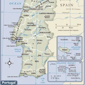
Medieval Spain and Portugal map
Map of the Iberian Peninsula in the 1300s and 1400s.
Printed color lithograph reproduction of a 19th-century illustration
North Wind Picture Archives brings history to life with stock images and hand-colored illustrations
Media ID 5882217
© North Wind Picture Archives
1300s 1400s 14th Century 15th Century Europe European Granada Medieval Middle Ages Moors Portugal Portuguese Spain Spanish Aragon Castile Gibraltar Iberia Iberian Peninsula Navarra
Greetings Card (A5)
Discover the rich history and cultural connections of Medieval Spain and Portugal with our exquisite range of greeting cards from Media Storehouse. Each card features a stunning, color lithograph reproduction of a 19th-century illustration from North Wind Picture Archives. This particular design showcases an intricately detailed map of the Iberian Peninsula as it appeared during the 1300s and 1400s, a time when the regions were intertwined through trade, exploration, and the spread of various influences. Perfect for history enthusiasts or anyone looking to add a touch of Old World charm to their correspondence, these high-quality greeting cards are sure to impress.
Create your own greetings card. Size when folded is A5 (14.5x21cm or 5.7x8.3 inches)
Greetings Cards suitable for Birthdays, Weddings, Anniversaries, Graduations, Thank You and much more
Estimated Image Size (if not cropped) is 21cm x 14.5cm (8.3" x 5.7")
Estimated Product Size is 21cm x 29cm (8.3" x 11.4")
These are individually made so all sizes are approximate
Artwork printed orientated as per the preview above, with landscape (horizontal) orientation to match the source image.
FEATURES IN THESE COLLECTIONS
> Arts
> Art Movements
> Medieval Art
> Europe
> Portugal
> Related Images
> Europe
> Spain
> Related Images
> Maps and Charts
> Related Images
> North Wind Picture Archives
> Maps
EDITORS COMMENTS
This print takes us on a journey back in time to the medieval era of Spain and Portugal. With its vibrant colors and intricate details, it beautifully captures the essence of the Iberian Peninsula during the 1300s and 1400s. The map showcases the rich history and heritage of this region, highlighting key cities such as Granada, Gibraltar, Aragon, Castile, Navarra, and more. Each city is marked with precision, allowing us to trace the footsteps of ancient civilizations that once thrived here. As we explore this vintage illustration, we are transported to a world where traditional architecture meets European charm. The artistry behind this lithograph reproduction truly brings out the grandeur of medieval Spain and Portugal. One cannot help but marvel at how this map encapsulates centuries of cultural exchange between Christians and Moors. It serves as a testament to their coexistence during these tumultuous times in history. Whether you are an art enthusiast or a history buff, this print offers a glimpse into Europe's fascinating past. It serves as a reminder that even amidst political turmoil and territorial disputes, beauty can be found in every corner of our shared human experience
MADE IN THE UK
Safe Shipping with 30 Day Money Back Guarantee
FREE PERSONALISATION*
We are proud to offer a range of customisation features including Personalised Captions, Color Filters and Picture Zoom Tools
SECURE PAYMENTS
We happily accept a wide range of payment options so you can pay for the things you need in the way that is most convenient for you
* Options may vary by product and licensing agreement. Zoomed Pictures can be adjusted in the Basket.