Premium Framed Print > Europe > France > Canton > Landes
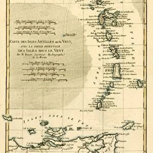
Premium Framed Print : 1683, Mortier Map of North America, the West Indies, and the Atlantic Ocean, topography


![]()
Framed Photos from Liszt Collection
1683, Mortier Map of North America, the West Indies, and the Atlantic Ocean, topography
1683, Mortier Map of North America, the West Indies, and the Atlantic Ocean
Liszt Collection of nineteenth-century engravings and images to browse and enjoy
Media ID 14004459
© Artokoloro Quint Lox Limited
1683 Antique Map Latitude Longitude Mappa Mundi Old Antique Plan Old Antique View Ols Antique Map Rare Old Maps Topo
17"x15" (43x38cm) Premium Frame
FSC real wood frame with double mounted 10x8 print. Double mounted with white conservation mountboard. Frame moulding comprises stained composite natural wood veneers (Finger Jointed Pine) 39mm wide by 21mm thick. Archival quality Fujifilm CA photo paper mounted onto 1mm card. Overall outside dimensions are 17x15 inches (431x381mm). Rear features Framing tape to cover staples, 50mm Hanger plate, cork bumpers. Glazed with durable thick 2mm Acrylic to provide a virtually unbreakable glass-like finish. Acrylic Glass is far safer, more flexible and much lighter than typical mineral glass. Moreover, its higher translucency makes it a perfect carrier for photo prints. Acrylic allows a little more light to penetrate the surface than conventional glass and absorbs UV rays so that the image and the picture quality doesn't suffer under direct sunlight even after many years. Easily cleaned with a damp cloth. Please note that, to prevent the paper falling through the mount window and to prevent cropping of the original artwork, the visible print may be slightly smaller to allow the paper to be securely attached to the mount without any white edging showing and to match the aspect ratio of the original artwork.
FSC Real Wood Frame and Double Mounted with White Conservation Mountboard - Professionally Made and Ready to Hang
Estimated Image Size (if not cropped) is 24.4cm x 19.4cm (9.6" x 7.6")
Estimated Product Size is 43.1cm x 38.1cm (17" x 15")
These are individually made so all sizes are approximate
Artwork printed orientated as per the preview above, with landscape (horizontal) orientation to match the source image.
FEATURES IN THESE COLLECTIONS
> Arts
> Artists
> O
> Oceanic Oceanic
> Europe
> France
> Canton
> Landes
> Historic
> Space exploration
> Maps and Charts
> Early Maps
> Maps and Charts
> Related Images
> Maps and Charts
> World
EDITORS COMMENTS
This print showcases the 1683 Mortier Map of North America, the West Indies, and the Atlantic Ocean. With its intricate topography, this vintage map takes us back in time to an era of exploration and discovery. The artistry and attention to detail evident in this cartographic masterpiece are truly remarkable. The map's depiction of landforms, illustrated with precision and accuracy, allows us to visualize the geographical features that shaped these regions centuries ago. Its grid system based on latitude and longitude provides a navigational tool for adventurers seeking new frontiers. As we gaze upon this ancient artifact, we can't help but marvel at how it captures a snapshot of history frozen in time. The aged paper adds a touch of nostalgia while reminding us of the countless journeys made by explorers who relied on maps like these to navigate uncharted territories. This decorative piece serves as a window into our planet's past—a mappa mundi that reveals not only physical landscapes but also hints at cultural exchanges between different regions. It reminds us that even in an age where satellite imagery dominates our understanding of geography, there is still beauty and value in studying old antique maps like this one. Whether you're an avid collector or simply appreciate historical artifacts, this rare Mortier Map print offers a glimpse into a world long gone yet forever preserved through artful cartography.
MADE IN THE UK
Safe Shipping with 30 Day Money Back Guarantee
FREE PERSONALISATION*
We are proud to offer a range of customisation features including Personalised Captions, Color Filters and Picture Zoom Tools
SECURE PAYMENTS
We happily accept a wide range of payment options so you can pay for the things you need in the way that is most convenient for you
* Options may vary by product and licensing agreement. Zoomed Pictures can be adjusted in the Basket.