Photographic Print > Europe > France > Canton > Landes
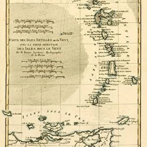
Photographic Print : 1683, Mortier Map of North America, the West Indies, and the Atlantic Ocean, topography


![]()
Photo Prints from Liszt Collection
1683, Mortier Map of North America, the West Indies, and the Atlantic Ocean, topography
1683, Mortier Map of North America, the West Indies, and the Atlantic Ocean
Liszt Collection of nineteenth-century engravings and images to browse and enjoy
Media ID 14004459
© Artokoloro Quint Lox Limited
1683 Antique Map Latitude Longitude Mappa Mundi Old Antique Plan Old Antique View Ols Antique Map Rare Old Maps Topo
10"x8" (25x20cm) Photo Print
Discover history through the lens with our exclusive Media Storehouse Photographic Prints. This captivating piece showcases the 1683 Mortier Map of North America, the West Indies, and the Atlantic Ocean from the renowned Liszt Collection. Each print is meticulously crafted to bring out the intricate details and vibrant colors of this historical cartographic masterpiece. Transport yourself back in time and adorn your walls with a piece of history that tells a story of exploration and discovery. Order now and bring a piece of the past into your present.
Printed on archival quality paper for unrivalled stable artwork permanence and brilliant colour reproduction with accurate colour rendition and smooth tones. Printed on professional 234gsm Fujifilm Crystal Archive DP II paper. 10x8 for landscape images, 8x10 for portrait images.
Our Photo Prints are in a large range of sizes and are printed on Archival Quality Paper for excellent colour reproduction and longevity. They are ideal for framing (our Framed Prints use these) at a reasonable cost. Alternatives include cheaper Poster Prints and higher quality Fine Art Paper, the choice of which is largely dependant on your budget.
Estimated Product Size is 25.4cm x 20.3cm (10" x 8")
These are individually made so all sizes are approximate
Artwork printed orientated as per the preview above, with landscape (horizontal) or portrait (vertical) orientation to match the source image.
FEATURES IN THESE COLLECTIONS
> Arts
> Artists
> O
> Oceanic Oceanic
> Europe
> France
> Canton
> Landes
> Historic
> Space exploration
> Maps and Charts
> Early Maps
> Maps and Charts
> Related Images
> Maps and Charts
> World
EDITORS COMMENTS
This print showcases the 1683 Mortier Map of North America, the West Indies, and the Atlantic Ocean. With its intricate topography, this vintage map takes us back in time to an era of exploration and discovery. The artistry and attention to detail evident in this cartographic masterpiece are truly remarkable. The map's depiction of landforms, illustrated with precision and accuracy, allows us to visualize the geographical features that shaped these regions centuries ago. Its grid system based on latitude and longitude provides a navigational tool for adventurers seeking new frontiers. As we gaze upon this ancient artifact, we can't help but marvel at how it captures a snapshot of history frozen in time. The aged paper adds a touch of nostalgia while reminding us of the countless journeys made by explorers who relied on maps like these to navigate uncharted territories. This decorative piece serves as a window into our planet's past—a mappa mundi that reveals not only physical landscapes but also hints at cultural exchanges between different regions. It reminds us that even in an age where satellite imagery dominates our understanding of geography, there is still beauty and value in studying old antique maps like this one. Whether you're an avid collector or simply appreciate historical artifacts, this rare Mortier Map print offers a glimpse into a world long gone yet forever preserved through artful cartography.
MADE IN THE UK
Safe Shipping with 30 Day Money Back Guarantee
FREE PERSONALISATION*
We are proud to offer a range of customisation features including Personalised Captions, Color Filters and Picture Zoom Tools
SECURE PAYMENTS
We happily accept a wide range of payment options so you can pay for the things you need in the way that is most convenient for you
* Options may vary by product and licensing agreement. Zoomed Pictures can be adjusted in the Basket.