Premium Framed Print > Arts > Artists > C > Juan de la Cosa
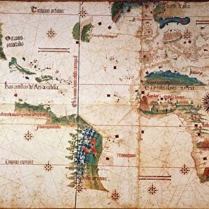
Premium Framed Print : NINA: WORLD MAP, 1500. World map, 1500, of Juan de la Cosa, navigator on the Nina on Christopher Columbus second voyage


![]()
Framed Photos from Granger
NINA: WORLD MAP, 1500. World map, 1500, of Juan de la Cosa, navigator on the Nina on Christopher Columbus second voyage
NINA: WORLD MAP, 1500. World map, 1500, of Juan de la Cosa, navigator on the Nina on Christopher Columbus second voyage of 1493-94
Granger holds millions of images spanning more than 25,000 years of world history, from before the Stone Age to the dawn of the Space Age
Media ID 6622077
1500 Africa Age Of Discovery Asia Bradley Smith Caribbean Cartography Christopher Columbus Expedition Exploration Explorer Juan New World Nina Portolan Chart Spain Spanish World Cosa
23"x19" (58x48cm) Premium Frame
FSC real wood frame with double mounted 16x12 print. Double mounted with white conservation mountboard. Frame moulding comprises stained composite natural wood veneers (Finger Jointed Pine) 39mm wide by 21mm thick. Archival quality Fujifilm CA photo paper mounted onto 1mm card. Overall outside dimensions are 23x19 inches (584x482mm). Rear features Framing tape to cover staples, 50mm Hanger plate, cork bumpers. Glazed with durable thick 2mm Acrylic to provide a virtually unbreakable glass-like finish. Acrylic Glass is far safer, more flexible and much lighter than typical mineral glass. Moreover, its higher translucency makes it a perfect carrier for photo prints. Acrylic allows a little more light to penetrate the surface than conventional glass and absorbs UV rays so that the image and the picture quality doesn't suffer under direct sunlight even after many years. Easily cleaned with a damp cloth. Please note that, to prevent the paper falling through the mount window and to prevent cropping of the original artwork, the visible print may be slightly smaller to allow the paper to be securely attached to the mount without any white edging showing and to match the aspect ratio of the original artwork.
FSC Real Wood Frame and Double Mounted with White Conservation Mountboard - Professionally Made and Ready to Hang
Estimated Image Size (if not cropped) is 39.6cm x 20.2cm (15.6" x 8")
Estimated Product Size is 58.4cm x 48.2cm (23" x 19")
These are individually made so all sizes are approximate
Artwork printed orientated as per the preview above, with landscape (horizontal) orientation to match the source image.
FEATURES IN THESE COLLECTIONS
> Granger Art on Demand
> Maps
> Africa
> Related Images
> Animals
> Mammals
> Soricidae
> Navigator
> Arts
> Art Movements
> Renaissance Art
> Arts
> Artists
> C
> Juan de la Cosa
> Asia
> Related Images
> Europe
> Spain
> Related Images
EDITORS COMMENTS
This print titled "NINA: WORLD MAP, 1500" takes us back to the early years of exploration and discovery. Created by Juan de la Cosa, a skilled navigator on Christopher Columbus' second voyage in 1493-94, this world map offers a glimpse into the Renaissance era of cartography. The intricate details showcased in this print highlight the ambition and curiosity that fueled expeditions during the Age of Discovery. As we study the map, we can trace Columbus' journey across the vast Atlantic Ocean towards uncharted territories. The Caribbean islands emerge as key landmarks, representing new lands encountered by European explorers. The artist's skillful rendering transports us to an era when maps were not only tools for navigation but also works of art. With delicate brushstrokes and precise attention to detail, Juan de la Cosa captures Africa's coastline extending eastward towards Asia while Spain proudly stands at its center. This remarkable piece from Bradley Smith's Carousel Collection invites us to reflect on humanity's insatiable thirst for knowledge and adventure. It serves as a reminder that it was through courageous individuals like Columbus and his crew aboard the Nina that our understanding of the world expanded exponentially. As we admire this historical artifact turned artwork, let us appreciate both its aesthetic beauty and its significance in shaping our collective history.
MADE IN THE UK
Safe Shipping with 30 Day Money Back Guarantee
FREE PERSONALISATION*
We are proud to offer a range of customisation features including Personalised Captions, Color Filters and Picture Zoom Tools
SECURE PAYMENTS
We happily accept a wide range of payment options so you can pay for the things you need in the way that is most convenient for you
* Options may vary by product and licensing agreement. Zoomed Pictures can be adjusted in the Basket.