Fine Art Print > Arts > Artists > C > Juan de la Cosa
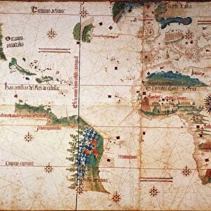
Fine Art Print : NINA: WORLD MAP, 1500. World map, 1500, of Juan de la Cosa, navigator on the Nina on Christopher Columbus second voyage


Resolution may be poor at this size (100 DPI)
![]()
Fine Art Prints from Granger
NINA: WORLD MAP, 1500. World map, 1500, of Juan de la Cosa, navigator on the Nina on Christopher Columbus second voyage
NINA: WORLD MAP, 1500. World map, 1500, of Juan de la Cosa, navigator on the Nina on Christopher Columbus second voyage of 1493-94
Granger holds millions of images spanning more than 25,000 years of world history, from before the Stone Age to the dawn of the Space Age
Media ID 6622077
1500 Africa Age Of Discovery Asia Bradley Smith Caribbean Cartography Christopher Columbus Expedition Exploration Explorer Juan New World Nina Portolan Chart Spain Spanish World Cosa
A2 (42x59cm) Fine Art Print
Discover the rich history of exploration with our Fine Art Print of Juan de la Cosa's World Map, 1500. This stunning piece, part of the Media Storehouse collection, showcases the intricate detail of one of the earliest known world maps. Navigator Juan de la Cosa created this map after joining Christopher Columbus' second voyage on the Nina in 1493-94. The Granger Collection's reproduction brings the vibrant colors and intricate line work to life, making it a captivating addition to any home or office. Transport yourself back in time and add a touch of history to your space with this exquisite Fine Art Print.
Our Fine Art Prints are printed on 100% acid free, PH neutral paper with archival properties. This printing method is used by museums and art collections to exhibit photographs and art reproductions. Hahnemühle certified studio for digital fine art printing. Printed on 308gsm Photo Rag Paper.
Our fine art prints are high-quality prints made using a paper called Photo Rag. This 100% cotton rag fibre paper is known for its exceptional image sharpness, rich colors, and high level of detail, making it a popular choice for professional photographers and artists. Photo rag paper is our clear recommendation for a fine art paper print. If you can afford to spend more on a higher quality paper, then Photo Rag is our clear recommendation for a fine art paper print.
Estimated Image Size (if not cropped) is 59.4cm x 30.3cm (23.4" x 11.9")
Estimated Product Size is 59.4cm x 42cm (23.4" x 16.5")
These are individually made so all sizes are approximate
Artwork printed orientated as per the preview above, with landscape (horizontal) orientation to match the source image.
FEATURES IN THESE COLLECTIONS
> Africa
> Related Images
> Animals
> Mammals
> Soricidae
> Navigator
> Arts
> Art Movements
> Renaissance Art
> Arts
> Artists
> C
> Juan de la Cosa
> Asia
> Related Images
> Europe
> Spain
> Related Images
> Granger Art on Demand
> Maps
EDITORS COMMENTS
This print titled "NINA: WORLD MAP, 1500" takes us back to the early years of exploration and discovery. Created by Juan de la Cosa, a skilled navigator on Christopher Columbus' second voyage in 1493-94, this world map offers a glimpse into the Renaissance era of cartography. The intricate details showcased in this print highlight the ambition and curiosity that fueled expeditions during the Age of Discovery. As we study the map, we can trace Columbus' journey across the vast Atlantic Ocean towards uncharted territories. The Caribbean islands emerge as key landmarks, representing new lands encountered by European explorers. The artist's skillful rendering transports us to an era when maps were not only tools for navigation but also works of art. With delicate brushstrokes and precise attention to detail, Juan de la Cosa captures Africa's coastline extending eastward towards Asia while Spain proudly stands at its center. This remarkable piece from Bradley Smith's Carousel Collection invites us to reflect on humanity's insatiable thirst for knowledge and adventure. It serves as a reminder that it was through courageous individuals like Columbus and his crew aboard the Nina that our understanding of the world expanded exponentially. As we admire this historical artifact turned artwork, let us appreciate both its aesthetic beauty and its significance in shaping our collective history.
MADE IN THE UK
Safe Shipping with 30 Day Money Back Guarantee
FREE PERSONALISATION*
We are proud to offer a range of customisation features including Personalised Captions, Color Filters and Picture Zoom Tools
SECURE PAYMENTS
We happily accept a wide range of payment options so you can pay for the things you need in the way that is most convenient for you
* Options may vary by product and licensing agreement. Zoomed Pictures can be adjusted in the Basket.