Premium Framed Print > Arts > Modern art pieces > Textures and patterns in modern > Modern paintings
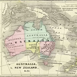
Premium Framed Print : South America Physical map 1897


![]()
Framed Photos from Fine Art Storehouse
South America Physical map 1897
The World-Wide Atlas of Modern Geography, Political and Physical W. & A.K. Johnston - London 1897
Unleash your creativity and transform your space into a visual masterpiece!
THEPALMER
Media ID 14757130
© Roberto A Sanchez
Argentina Atlantic Ocean Atlas Backgrounds Brazil Colombia Country Geographic Area Direction Earth Latin America Pacific Ocean Paper Patina Sepia Toned South America Textured Effect Uruguay Venezuela World Map Retro Styled
17"x15" (43x38cm) Premium Frame
FSC real wood frame with double mounted 10x8 print. Double mounted with white conservation mountboard. Frame moulding comprises stained composite natural wood veneers (Finger Jointed Pine) 39mm wide by 21mm thick. Archival quality Fujifilm CA photo paper mounted onto 1mm card. Overall outside dimensions are 17x15 inches (431x381mm). Rear features Framing tape to cover staples, 50mm Hanger plate, cork bumpers. Glazed with durable thick 2mm Acrylic to provide a virtually unbreakable glass-like finish. Acrylic Glass is far safer, more flexible and much lighter than typical mineral glass. Moreover, its higher translucency makes it a perfect carrier for photo prints. Acrylic allows a little more light to penetrate the surface than conventional glass and absorbs UV rays so that the image and the picture quality doesn't suffer under direct sunlight even after many years. Easily cleaned with a damp cloth. Please note that, to prevent the paper falling through the mount window and to prevent cropping of the original artwork, the visible print may be slightly smaller to allow the paper to be securely attached to the mount without any white edging showing and to match the aspect ratio of the original artwork.
FSC Real Wood Frame and Double Mounted with White Conservation Mountboard - Professionally Made and Ready to Hang
Estimated Image Size (if not cropped) is 18.7cm x 24.4cm (7.4" x 9.6")
Estimated Product Size is 38.1cm x 43.1cm (15" x 17")
These are individually made so all sizes are approximate
Artwork printed orientated as per the preview above, with portrait (vertical) orientation to match the source image.
FEATURES IN THESE COLLECTIONS
> Fine Art Storehouse
> Map
> Historical Maps
> Arts
> Artists
> O
> Oceanic Oceanic
> Arts
> Modern art pieces
> Textures and patterns in modern
> Modern paintings
> Arts
> Modern art pieces
> Textures and patterns in modern
> Europe
> United Kingdom
> England
> London
> Politics
> Related Images
> Europe
> United Kingdom
> England
> London
> Related Images
> Maps and Charts
> Related Images
> Maps and Charts
> World
EDITORS COMMENTS
This print takes us back in time to the year 1897, when cartography was a meticulous art form. The South America Physical map featured in this image is part of "The World-Wide Atlas of Modern Geography, Political and Physical" by W. & A. K. Johnston - London 1897. With its retro-styled appearance and antique charm, this engraved image showcases the intricate details of South America's physical geography. From Venezuela to Uruguay, Colombia to Brazil, Argentina to every country within the region, each geographic area is meticulously depicted with precision and accuracy. The sepia-toned textured effect adds an extra layer of nostalgia, as if we are peering into a treasured relic from another era. As we gaze upon this piece, we can almost feel the texture of the paper and imagine how it would have been held in hands long ago. The vastness of South America unfolds before our eyes as we observe its borders stretching across both the Pacific Ocean and Atlantic Ocean. The sea surrounding these landmasses serves as a reminder of their connection to the rest of our planet Earth. Every line etched onto this map carries with it a sense of history—a patina that speaks volumes about exploration and discovery during that time period. This print by THEPALMER transports us back in time while simultaneously reminding us of the enduring beauty found within old maps like these.
MADE IN THE UK
Safe Shipping with 30 Day Money Back Guarantee
FREE PERSONALISATION*
We are proud to offer a range of customisation features including Personalised Captions, Color Filters and Picture Zoom Tools
SECURE PAYMENTS
We happily accept a wide range of payment options so you can pay for the things you need in the way that is most convenient for you
* Options may vary by product and licensing agreement. Zoomed Pictures can be adjusted in the Basket.